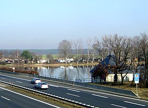
Radeburg I storage facility
| Radeburg I storage facility | |||||||||
|---|---|---|---|---|---|---|---|---|---|
| In the back the reservoir, in front the motorway over the dam | |||||||||
|
|||||||||
|
|
|||||||||
| Coordinates | 51 ° 12 '53 " N , 13 ° 44' 28" E | ||||||||
| Data on the structure | |||||||||
| Construction time: | 1937-1939 | ||||||||
| Height above valley floor: | 6.5 m | ||||||||
| Height above foundation level : | 10 m | ||||||||
| Height of the structure crown: | 148.95 m | ||||||||
| Crown length: | 270 m | ||||||||
| Slope slope on the water side : | 1: 3 | ||||||||
| Data on the reservoir | |||||||||
| Altitude (at congestion destination ) | 148 m | ||||||||
| Water surface | 37 ha | ||||||||
| Storage space | 0.69 million m³ | ||||||||
| Total storage space : | 0.85 million m³ | ||||||||
| Catchment area | 303 km² | ||||||||
The Radeburg I reservoir (Radeburger Stausee or Röderstausee) was built in 1937–1939, but was not put into operation until 1951. It is located at the Radeburg exit of the Dresden – Berlin motorway ( A 13 ). The barrier dam, an earth dam with an inclined inner seal made of clay, is part of the motorway embankment . The Große Röder is dammed .
The system is used for flood protection , low water elevation , drinking and service water supply in conjunction with the Radeburg II storage facility, and local recreation . If necessary, water is fed into the Radeburg II reservoir via a distribution channel.
There is a campsite right by the reservoir .
See also:
Web links
Commons : Speicher Radeburg I - Collection of images, videos and audio files

