Röderaue
| coat of arms | Germany map | |
|---|---|---|

|
Coordinates: 51 ° 24 ' N , 13 ° 29' E |
|
| Basic data | ||
| State : | Saxony | |
| County : | Meissen | |
| Management Community : | Röderaue-Wülknitz | |
| Height : | 97 m above sea level NHN | |
| Area : | 28.82 km 2 | |
| Residents: | 2611 (Dec. 31, 2019) | |
| Population density : | 91 inhabitants per km 2 | |
| Postal code : | 01609 | |
| Area code : | 035263 | |
| License plate : | MEI, GRH, RG, RIE | |
| Community key : | 14 6 27 240 | |
| Community structure: | 4 districts | |
| Address of the municipal administration: |
Radener Strasse 2 01609 Röderaue |
|
| Website : | ||
| Mayor : | Lothar Herklotz ( CDU ) | |
| Location of the community Röderaue in the district of Meißen | ||
Röderaue is a municipality in the north of the district of Meißen in the Free State of Saxony . It is the seat of the Röderaue-Wülknitz administrative association .
geography
Geographical location
The community is located in the Großenhainer care in the Röderaue and is characterized by large forest and pond landscapes. Around one third of the municipality is forest and around one tenth is water. Neighboring cities are Elsterwerda (14 km), Großenhain (15 km), Gröditz (2 km) and Riesa (16 km). The federal highways 169 and 101 run through the municipality. The Riesa – Elsterwerda and Dresden – Berlin railway lines also run through the municipality. The Elsterwerda-Grödel-Floßkanal , the Geißlitz and the Große Röder run through the municipality .
Community structure
The community Röderaue consists of the districts Frauenhain , Koselitz , Pulsen and Raden .
history
The community was created on January 1, 1994 through the merger of the previously independent communities of Frauenhain, Koselitz, Pulsen and Raden.
politics
Municipal council
Since the municipal council election on May 25, 2014 , the 12 seats of the municipal council have been distributed among the individual groups as follows:
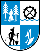
coat of arms
Above left: Frauenhain, the woman at the grove
Above right: Raden, the mill wheel to Raden
Below left: Koselitz, the devil. Based on the legend of the Teufelsgraben
Bottom right: Pulsen, the plow stands for agriculture
Culture and sights
- see also: List of cultural monuments in Röderaue
Attractions
- Grain and sawmill in the Raden district
- Landscape protection area Röderaue
- Church with altar painting "The Three Marys", Koselitz
- numerous ponds with bike and hiking trails (e.g. the Röderradroute )
- Old castle cemetery in Frauenhain
- Church of Frauenhain with the oldest church bell in Saxony
Memorials
- Tombs and memorial to 27 concentration camp prisoners of the subcamp Groeditz the Flossenburg concentration camp , as well as 74 women and 69 children of Ostarbeiterinnenlagers Frauenhain that during the Second World War deported to Germany and victims of forced labor were
- Memorial and graves in the district of pulses in the vicinity of the swimming pool Groeditz for at least 150 forced laborers (s), primarily from the Soviet Union , in the outer bearing steel plant Groeditz of Flossenbiirg forced to work had
Regular events
- March / April: Frauenhainer Katzengebirge Run
- April 30th: May fire on the island of Frauenhain
- June: Inselfest Frauenhain
- July: Saxstock Festival
- September: Natural market "Flora et Herba" on the island of Frauenhain
Web links
- Röderaue in the Digital Historical Directory of Saxony
- Röderaue natural area
- Röderaue community
- District of Koselitz


