
Lampertswalde
| coat of arms | Germany map | |
|---|---|---|

|
Coordinates: 51 ° 19 ′ N , 13 ° 40 ′ E |
|
| Basic data | ||
| State : | Saxony | |
| County : | Meissen | |
| Management Community : | Schönfeld | |
| Height : | 152 m above sea level NHN | |
| Area : | 63.65 km 2 | |
| Residents: | 2547 (Dec. 31, 2019) | |
| Population density : | 40 inhabitants per km 2 | |
| Postal code : | 01561 | |
| Area code : | 035248 | |
| License plate : | MEI, GRH, RG, RIE | |
| Community key : | 14 6 27 110 | |
| LOCODE : | DE LPW | |
| Community structure: | 10 districts | |
| Address of the municipal administration: |
Ortrander Strasse 2 01561 Lampertswalde |
|
| Website : | ||
| Mayor : | Wolfgang Hoffmann ( independent ) | |
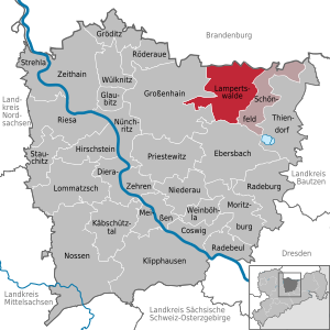
| Location of the municipality of Lampertswalde in the district of Meißen | ||
  |
||

Lampertswalde is a municipality in Saxony . It belongs to the Schönfeld administrative community .
geography
The community is located on the eastern edge of the Großenhainer Pflege at the transition to the Westlausitzer Bergland . The neighboring cities are the city of Großenhain (10 km), Königsbrück (20 km) and Radeburg (13 km). The community borders the state of Brandenburg to the north , the communities Schönfeld and Ebersbach to the east and south, and the city of Großenhain to the west.
Local division
The districts of the community are Adelsdorf (name of the community from September 30, 1950 to April 30, 1991 Dorf der Jugend ), Blochwitz , Brockwitz , Brößnitz , Lampertswalde, Mühlbach , Oelsnitz-Niegeroda , Quersa , Schönborn and Weißig am Raschütz .
The following table shows the districts of Lampertswaldes with their population (as of January 1, 2015).
| District | Residents |
|---|---|
| Lampertswalde | 1011 |
| Weißig on the Raschütz | 302 |
| Quersa | 287 |
| Blochwitz | 247 |
| Oelsnitz | 229 |
| Adelsdorf | 199 |
| Schönborn | 185 |
| Brockwitz | 139 |
| Broessnitz | 102 |
| Niegeroda | 68 |
| Mühlbach | 55 |
history
The village of Lampertswalde was created as a forest hoof village. In 1219 the place was first mentioned according to a document from the copial book (collection of copies) of the monastery in Meißen with the name Lamprechtiswalde .
Already on July 1, 1950, the place Mühlbach was incorporated. On July 1, 1996, the community Quersa - Brockwitz was incorporated, which was created on January 1, 1973 through the merger of the two namesake places. On January 1, 1997, the formerly independent town of Adelsdorf followed . Finally, on January 1, 1999, Schönborn was incorporated.
On January 1, 2012, the municipality of Weißig am Raschütz was incorporated into Lampertswalde.
Attractions

- see also: List of cultural monuments in Lampertswalde
- Tower windmill and historical wind turbine as well as a war memorial for the fallen of the First World War in Schönborn
- Original remnant of the Saxon quarter milestone from 1722, which stood on Poststrasse in the course of the Via Regia near Quersa (currently in storage, replica planned for the B98 )
- Martinskirche, since 1883 under this name ( Martin Luther is said to have preached in Lampertswalde), the oldest mention of a church in the village is from the year 1206. The chancel was designed in 1973 by the Saxon artist Werner Juza .

Pageant for the 800th anniversary (2006)

The factory of the Kronospan company
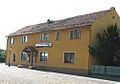
Thiel's inn
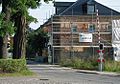
Railroad Crossing


Memorials
- Memorial stone on the road to Skaup for seven concentration camp prisoners who were murdered by SS men at the end of the Second World War
politics
Since the municipal council election on May 25, 2014 , the 16 seats of the municipal council have been distributed among the individual groups as follows:
- Sports club Lampertswalde eV (SVL): 6 seats
- CDU : 4 seats
- Male Choir Lampertswalde (MGV): 2 seats
- SPD : 1 seat
- Blochwitz Society Association 94 eV (BGV): 1 seat
- IG Dorffest Weißig aR (IGD): 1 seat
- Free voters Lampertswalde (FWL): 1 seat
economy

The largest employer in the region is the Kronospan company ; the plant was built in 1993–94 by Union-Bau AG .
traffic
Lampertswalde is on the Grossenhain – Cottbus railway line . There are hourly connections in the direction of Ruhland and Dresden, the trains run as RE 15 and RE 18 of the DB Regio Nordost. In addition, the B 98 runs through the municipality. The A 13 running east of the community can be reached via the Schönborn and Thiendorf connections .
literature
- Cornelius Gurlitt : Lampertswalde. In: Descriptive representation of the older architectural and art monuments of the Kingdom of Saxony. 37. Issue: Amtshauptmannschaft Grossenhain (Land) . CC Meinhold, Dresden 1914, p. 124.
Web links
- Lampertswalde in the Digital Historical Directory of Saxony
Individual evidence
- ↑ Population of the Free State of Saxony by municipalities on December 31, 2019 ( help on this ).
- ↑ a b c municipalities 1994 and their changes since January 1, 1948 in the new federal states , Metzler-Poeschel publishing house, Stuttgart, 1995, ISBN 3-8246-0321-7 , publisher: Federal Statistical Office
- ↑ Archived copy ( Memento of the original from March 4, 2016 in the Internet Archive ) Info: The archive link was inserted automatically and has not yet been checked. Please check the original and archive link according to the instructions and then remove this notice.
- ^ StBA: Changes in the municipalities in Germany, see 1996
- ^ StBA: Changes in the municipalities in Germany, see 1997
- ↑ StBA: Changes in the municipalities in Germany, see 1999
- ↑ Lampertswalde Church. Meißen-Großenhain church district, accessed on March 10, 2014 .
- ↑ Results of the 2014 municipal council elections
Coswig | Diera-Zehren | Ebersbach | Glaubitz | Gröditz | Grossenhain | Hirschstein | Käbschützal | Klipphausen | Lampertswalde | Lommatzsch | Meissen | Moritzburg | Niederau | Nossen | Nünchritz | Priestewitz | Radebeul | Radeburg | Riesa | Röderaue | Schönfeld | Stauchitz | Strehla | Thiendorf | Weinböhla | Wülknitz | Zeithain