
Ebersbach (near Großenhain)
| coat of arms | Germany map | |
|---|---|---|

|
Coordinates: 51 ° 14 ′ N , 13 ° 40 ′ E |
|
| Basic data | ||
| State : | Saxony | |
| County : | Meissen | |
| Height : | 238 m above sea level NHN | |
| Area : | 84.38 km 2 | |
| Residents: | 4384 (Dec. 31, 2019) | |
| Population density : | 52 inhabitants per km 2 | |
| Postal code : | 01561 | |
| Area code : | 035208 | |
| License plate : | MEI, GRH, RG, RIE | |
| Community key : | 14 6 27 030 | |
| Community structure: | 14 districts | |
| Address of the municipal administration: |
Am Bahndamm 3 01561 Ebersbach |
|
| Website : | ||
| Mayor : | Falk Hentschel (CDU) | |
| Location of the municipality of Ebersbach in the district of Meißen | ||
  |
||

Ebersbach is a municipality in the district of Meißen in the Free State of Saxony . It is one of the largest municipalities in the district in terms of area.
Geography and traffic
The community is in the Grossenhainer care . Large parts of the landscape protection area Mittlere Röderaue and Kienheide lie in the territory of the municipality. The neighboring cities are the city of Großenhain (10 km), Radeburg (5 km) and Meißen (15 km). The A 13 runs east of the community and can be reached via the Radeburg junction . The Große Röder flows through the districts of Rödern, Freitelsdorf, Cunnersdorf , Bieberach and Kalkreuth .
Community structure
The official districts belong to the municipality:
- Beiersdorf
- Bieberach
- Cunnersdorf
- Ebersbach (Nieder-, Mittel- and Oberebersbach)
- Ermendorf
- Freitelsdorf
- Gohra
- Hohndorf
- Kalkreuth
- Lauterbach
- Marschau
- Naunhof
- Reinersdorf
- Rödern (Nieder- and Oberrödern)
Neighboring communities
Ebersbach is completely surrounded by towns and communities in the district of Meißen. These are Lampertswalde in the north, Schönfeld in the northeast, Thiendorf in the east, Radeburg in the southeast, Moritzburg in the south, Niederau in the southwest, Priestewitz in the west and Grossenhain in the northwest.
history
Kalkreuth was first mentioned in a document at the beginning of the 13th century.
On September 1, 1961, the community Ebersbach was formed through the merger of the predecessor communities Niederebersbach and Ober- and Mittelebersbach. On January 1, 1994, several formerly independent places were incorporated. On January 1st, 1998 Naunhof was incorporated. On January 1, 1999, Beiersdorf and Reinersdorf followed.
Incorporations
| Former parish | date | annotation |
|---|---|---|
| Beiersdorf | January 1, 1999 | |
| Bieberach | January 1, 1994 | |
| Cunnersdorf | 1st January 1973 | Merger with Freitelsdorf to form Freitelsdorf-Cunnersdorf |
| Ermendorf | July 1, 1950 | Incorporation to Beiersdorf |
| Freitelsdorf | 1st January 1973 | Merger with Cunnersdorf to form Freitelsdorf-Cunnersdorf |
| Freitelsdorf-Cunnersdorf | January 1, 1994 | |
| Gohra | January 1, 1995 | Re-congregation from Weßnitz to Reinersdorf, 1973 incorporation to Weßnitz |
| Hohndorf | July 1, 1950 | Incorporation to Beiersdorf |
| Kalkreuth | January 1, 1994 | |
| Lauterbach | July 1, 1948 | Incorporation to Beiersdorf |
| Marschau | April 1, 1937 | Incorporation to Lauterbach |
| Naunhof | January 1, 1998 | |
| Niederebersbach | September 1, 1961 | Merger with Ober- and Mittelebersbach to Ebersbach |
| Letting down | July 1, 1950 | Merger with Oberrödern to Rödern |
| Oberrödern | July 1, 1950 | Merger with Niederrödern to Rödern |
| Ober- and Mittelebersbach | September 1, 1961 | Merger with Niederebersbach to Ebersbach |
| Reinersdorf | January 1, 1999 | |
| Rödern | January 1, 1994 |
politics
Municipal council
The local election on May 25, 2014 resulted in the following distribution of seats in the local council:
| Party / list | CDU | FWG | The left | fire Department | FDP | total |
| Seats 2014 (2009) | 10 (10) | 4 (6) | 1 (1) | 2 (1) | 1 (0) | 18th |
| Share of votes | 51.4% | 21.2% | 7.1% | 11.9% | 8.3% | 18th |
Community partnerships
Ebersbach's partner communities are Kalchreuth in Bavaria and Krautheim in Baden-Württemberg.
traffic
State road 91 runs through the municipality of Ebersbach from the north (Kalkreuth) to the east (Rödern) . The closest junction to the A 13 is in Radeburg.
At no time did Ebersbach have its own rail connection. Depending on the district, the nearest train station is Großenhain Cottb Bf or Lampertswalde on the railway line from Priestewitz to Cottbus or Weinböhla on the railway line Leipzig – Dresden . The terminus of the narrow-gauge Lößnitzgrundbahn is located in Radeburg .
Attractions
- Rödernsche Heide
- Lauterbach Castle and Park
- Naunhof Castle and Nature Park
- Niederrödern Church from 1651
- Hunting villa in the castle park in Rödern, the important Renaissance castle was demolished after the Second World War
- Church in Niederebersbach
- Church in Oberebersbach from 1220
- numerous half-timbered houses
- Gut Kalkreuth with castle, sheep and farm yard

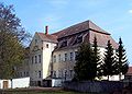
Lauterbach Castle, as of April 2017
Naunhof Castle

Cellar tavern Lauterbach

Naunhof windmill

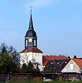
Naunhof Church

Reinersdorf Church
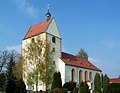
Oberebersbach Church
Niederebersbach church


Personalities
- Christian Schütz (1526–1592), Saxon court preacher, worked in Reinersdorf in 1550
- Johann Michael Francke (1717–1775), German librarian
- Walter Woldemar Wilhelm (1886 – after 1945), Saxon Minister of Economics 1927, owner of Lauterbach Castle
- Albrecht Schultz (1919–2007), manager
- Horst Rasch (* 1953), politician and Saxony Minister of the Interior from 2002–2004
Web links
- Community website
- Ebersbach in the Digital Historical Directory of Saxony
Individual evidence
- ↑ Population of the Free State of Saxony by municipalities on December 31, 2019 ( help on this ).
- ^ Official parts of the municipality of Ebersbach in the Saxony regional register
- ↑ Municipalities 1994 and their changes since January 1, 1948 in the new federal states , Metzler-Poeschel publishing house, Stuttgart, 1995, ISBN 3-8246-0321-7 , publisher: Federal Statistical Office
- ^ StBA: Changes in the municipalities in Germany, see 1998
- ↑ StBA: Changes in the municipalities in Germany, see 1999
- ↑ Results of the 2014 municipal council elections
- ↑ Results of the municipal council election 2009
Coswig | Diera-Zehren | Ebersbach | Glaubitz | Gröditz | Grossenhain | Hirschstein | Käbschützal | Klipphausen | Lampertswalde | Lommatzsch | Meissen | Moritzburg | Niederau | Nossen | Nünchritz | Priestewitz | Radebeul | Radeburg | Riesa | Röderaue | Schönfeld | Stauchitz | Strehla | Thiendorf | Weinböhla | Wülknitz | Zeithain