
Diera-Zehren
| coat of arms | Germany map | |
|---|---|---|

|
Coordinates: 51 ° 12 ' N , 13 ° 26' E |
|
| Basic data | ||
| State : | Saxony | |
| County : | Meissen | |
| Height : | 157 m above sea level NHN | |
| Area : | 43.21 km 2 | |
| Residents: | 3240 (Dec. 31, 2019) | |
| Population density : | 75 inhabitants per km 2 | |
| Postal code : | 01665 | |
| Primaries : | 035267 or 035247 or 03521 | |
| License plate : | MEI, GRH, RG, RIE | |
| Community key : | 14 6 27 020 | |
| Address of the municipal administration: |
Am Göhrischblick 1 01665 Diera-Zehren |
|
| Website : | ||
| Mayoress : | Carola Balk ( independent ) | |
| Location of the municipality of Diera-Zehren in the district of Meißen | ||
  |
||

Diera-Zehren is a municipality in the center of Saxony in the district of Meißen .
Geography and traffic
The municipality of Diera-Zehren is located in the northern part of the district on both banks of the Elbe. It is located about 6 kilometers northwest of Meißen and 16 kilometers southeast of Riesa . The B 6 , which follows the route of the old Poststrasse between Dresden and Leipzig, runs through the municipality. The place Zehren is at the mouth of the Ketzerbach in the Elbe . The districts on the left-hand side of the Elbe belong to the Lommatzscher care , those on the right-hand side to the Großenhainer care . Several districts of the community are counted among the Elbe wine villages . A yaw ferry between Kleinzadel and Niedermuschütz connects the districts on the left and right Elbe, but is currently out of service.
Community structure
Left Elbe districts:
districts on the right Elbe:
history
On January 1, 1999, the independent communities of Diera (with the districts of Golk, Kleinzadel, Löbsal, Naundörfel, Nieschütz and Zadel) and Zehren (with the districts of Keilbusch, Mischwitz, Naundorf, Ober- and Niederlommatzsch, Ober- and Niedermuschütz, Schieritz, Seebschütz and Seilitz) have merged to form the new municipality of Diera-Zehren with a total of 21 districts.
politics
Since the municipal council election on May 25, 2014 , the 16 seats of the municipal council have been distributed among the individual groups as follows:
- Citizens of Diera-Zehren (BDZ): 7 seats
- CDU : 5 seats
- New voter community Diera-Zehren (NWG): 3 seats
- Voters' association "Zukunft Diera-Zehren" (ZDZ): 1 seat
Culture and sights
- see also: List of cultural monuments in Diera-Zehren
- Elbepark Hebelei (animal enclosure)
- Kleinzadel local history museum
- neo-Gothic church Zadel (consecrated in 1841)
- baroque Michaeliskirche Zehren (built 1756–1785)
- Technical monument of the Schieritz watermill from 1361
- Schieritz Castle (built between 1556 and 1601)
- Zehren Local History and School Museum
- Seilitz - the smallest mine in Europe

St. Michaelis Church in Zehren

St. Andrew's Church in Zadel
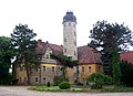
Schieritz Castle


Web links
- Diera-Zehren municipality
- Information about Diera-Zehren
- Diera-Zehren in the Digital Historical Directory of Saxony
Individual evidence
- ↑ Population of the Free State of Saxony by municipalities on December 31, 2019 ( help on this ).
- ^ History of the left side of the Elbe . Diera-Zehren municipality. Retrieved January 4, 2017.
- ↑ What makes Diera-Zehren so special . MDR. September 28, 2016. Archived from the original on January 4, 2017. Info: The archive link has been inserted automatically and has not yet been checked. Please check the original and archive link according to the instructions and then remove this notice.
- ↑ Small needle - Niedermuschütz . Diera-Zehren municipality. Retrieved January 4, 2017.
- ↑ StBA: Changes in the municipalities in Germany, see 1999
- ↑ Results of the 2014 municipal council elections
Coswig | Diera-Zehren | Ebersbach | Glaubitz | Gröditz | Grossenhain | Hirschstein | Käbschützal | Klipphausen | Lampertswalde | Lommatzsch | Meissen | Moritzburg | Niederau | Nossen | Nünchritz | Priestewitz | Radebeul | Radeburg | Riesa | Röderaue | Schönfeld | Stauchitz | Strehla | Thiendorf | Weinböhla | Wülknitz | Zeithain