Nieschütz
|
Nieschütz
Diera-Zehren municipality
Coordinates: 51 ° 13 ′ 20 ″ N , 13 ° 25 ′ 10 ″ E
|
||
|---|---|---|
| Height : | 104 m above sea level NN | |
| Residents : | 591 (May 9, 2011) | |
| Incorporation : | March 1, 1974 | |
| Incorporated into: | Diera | |
| Postal code : | 01665 | |
|
Location of Nieschütz in Saxony |
||
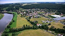
Nieschütz is a district of the Saxon community Diera-Zehren in the district of Meißen . The place is to the right of the Elbe , was first mentioned in 1239 and has belonged to Diera-Zehren since 1999. The municipal administration is located in Nieschütz.
geography
The place is about eight kilometers north of the district town of Meißen on a large Elbe arch and the "Rauhen Furt ". Nieschütz is located at 104 m above sea level. NN in the Lommatzscher care . The Golkwald joins the eastern edge of the village . The Gosebach (also called Nieschützbach) flows through Nieschütz . It rises west of Ockrilla and flows into the Elbe opposite the Göhrischgut . Nieschütz is divided into two town centers. The southern town center is arranged around the Gosebach, to the northeast of it is the second settlement core. Asparagus is grown on the slightly sandy soils around Nieschütz . A nursery operates extensive greenhouses between the two town centers.
Nieschütz is located on the Saxon state road 88, which connects the place with Nünchritz in the north and Meißen in the southeast. The state road runs through parts of the village in common with the county road 8010. It connects to Zadel in the south and to Kmehlen in the east. There is a pier on the Elbe in the north of the village. Part of the Elbe Cycle Path also runs along the banks of the Elbe in Nieschütz .
Nieschütz forms its own local marker , the dimensions of which correspond to the former municipality of Nieschütz before 1974. In the northeast, the Diesbar-Seusslitz district borders on Nieschütz. Golk is neighboring to the east , and Nieschütz's southern border is Zadel. The western border of the district forms the Elbe. In the west Nieschütz borders on Niedermuschütz , in the northwest on the district of Göhrisch . With the exception of Diesbar-Seusslitz, which belongs to the municipality of Nünchritz, all of the surrounding districts are part of Diera-Zehren.
history
| year | Residents |
|---|---|
| 1834 | 153 |
| 1871 | 206 |
| 1890 | 217 |
| 1910 | 273 |
| 1925 | 332 |
| 1933 | 391 |
| 1939 | 442 |
| 1946 | 563 |
| 1950 | 874 |
| 1964 | 853 |
| → Diera | |
| 2011 | 591 |
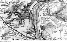
Nieschütz is first mentioned in 1239 as Nitswaz or Nitsvaz . The place name comes from Slavic and probably goes back to the name of the place founder Nisvad (= peaceful person). Nissewaz is mentioned in 1245 and Niswicz was passed down in 1321 . Another name variant dates from 1438, when Nischwicz is mentioned. Via Neschewicz (1466), Nitzewitz (1486), Nischitz (1543), Nitzschwitz (1552), Nitzschkowitz (1555) and Nietschitz (1696), the place name developed in the 19th century to the current form Nieschütz (outdated Nischütz ).
In the early modern period , Nieschütz was administered by different rulers. At the end of the 16th century, the place belonged to the Nossen office , then at the end of the 17th century to the Großenhain office and in the middle of the 18th century to the Zadel office. In the early 19th century Nieschütz was part of the Meißen hereditary office and from 1856 to the Meißen court office. From 1875 the administration was then incumbent on the Meißen district administration . Before Nieschütz was given independence as a rural community through the Saxon rural community order in 1838, the place was characterized by the feudal system . The Altzelle monastery (Altzella) exercised the manorial rule over 13 possessed men and three residents in 1552 . At the end of the 17th century, the lords of Zadel were the landlords, in the middle of the 18th century the village was owned by the prince and thus an official village. After the end of the Seven Years' War (1756–1763) he had the manorial rule over 15 possessed men and 6 cottagers who farmed 13 Hufen land. In addition, a deserted area on Nieschützer Flur was mentioned.
In 1900, a 193- hectare strip- like strip of land stretched around the square village of Nieschütz , which was almost exclusively used for agriculture, as the inhabitants of the village were primarily farmers. In 1834 153 people still lived in Nieschütz, there were already 217 in 1890. During this time, the north-eastern town center, known locally as "New Leipzig ", was built. By 1925 the population rose to 332. A survey carried out this year on the religious affiliation of the Nieschützer showed that the majority of 313 of the 332 inhabitants of the village were Evangelical Lutheran . The remaining 19 people were of other or no religion. Already in the 16th century the place was parish in the Zadel church. Today Nieschütz and the surrounding villages are part of the Zadel parish .
By 1939 the population in Nieschütz rose to 442 inhabitants. The state of Saxony came into the Soviet occupation zone after the Second World War and later became part of the GDR . In 1946 563 people lived in the village. On July 1, 1950, the formerly independent communities Golk and Löbsal were incorporated into Nieschütz, which increased the number of inhabitants to 874. Belonging to Meißen, which had existed since the 19th century, was retained even after the territorial reform in 1952 , which Nieschütz assigned as an independent municipality to the Meißen district in the Dresden district. The rural life in the place was based on the principle of agriculture in the GDR . On March 1, 1974, Nieschütz's independence, which had been achieved in 1838, ended again, and the place and its districts were incorporated into Diera . Zadel also joined Diera on the same date.
After the German reunification Nieschütz came to the re-established Free State of Saxony. Since the municipality of Diera with its 1700 to 2000 inhabitants was too small in the long term to remain independent, it formed the new municipality of Diera-Zehren with effect from January 1, 1999 with Zehren and its districts. Since then, Nieschütz has been one of the 21 districts of this municipality and has also been the seat of the Diera-Zehrens municipal administration. It is located at Am Göhrischblick 1. Diera-Zehren assigned the following regional reforms in Saxony in 1996 to the Meißen-Radebeul district and in 2008 to the Meißen district .
Today Nieschütz (excluding Golk and Löbsal) has about 600 inhabitants.
literature
- Elbe valley and Loess hill country near Meissen (= values of our homeland . Volume 32). 1st edition. Akademie Verlag, Berlin 1979, p. 86.
Web links
- Nieschütz in the Digital Historical Directory of Saxony
- Nieschütz on the Diera-Zehren website
Individual evidence
- ↑ a b c Population, households, families as well as buildings and apartments on May 9, 2011 according to parts of the municipality. (PDF; 690 KB) In: Kleinräumiges Gemeindeblatt Census 2011. Statistisches Landesamt Sachsen , p. 5 , accessed on October 4, 2016 .
- ↑ Search for geographical names. In: geodatenzentrum.de. Federal Agency for Cartography and Geodesy , accessed on May 20, 2013 .
- ↑ a b Nieschütz in the Digital Historical Directory of Saxony
- ^ A b Michael Rademacher: German administrative history from the unification of the empire in 1871 to the reunification in 1990. City and district of Meißen. (Online material for the dissertation, Osnabrück 2006).
- ↑ With the incorporation of Nieschütz into Diera in 1974, only official population figures were collected for the entire municipality.
- ↑ Nieschütz. In: diera-zehren.de. Diera-Zehren municipal administration, accessed on May 20, 2013 .
- ↑ Federal Statistical Office (Ed.): Municipalities 1994 and their changes since 01.01.1948 in the new federal states . Metzler-Poeschel, Stuttgart 1995, ISBN 3-8246-0321-7 .
- ↑ Changes in population / area for 14 2 80 060 municipality Diera. In: Regional Register Saxony. State Statistical Office of Saxony , accessed on May 20, 2013 .
- ↑ Area changes from 01.01. until December 31, 1999. In: destatis.de. Federal Statistical Office, accessed on May 20, 2013 .


