
Kutschenberg
| Kutschenberg | ||
|---|---|---|
 Kutschenberg (center) in the Kmehlener mountains |
||
| height | 201 m above sea level NHN | |
| location | between Großkmehlen and Blochwitz ; District of Oberspreewald-Lausitz and District of Meißen ; Brandenburg ( Germany ) | |
| Mountains | Kmehlener mountains | |
| Coordinates | 51 ° 21 '55 " N , 13 ° 43' 38" E | |
|
||
| Type | glacial terminal moraine | |
| rock | Attachments of the Drenthe stage of the Saale icing | |
| Age of the rock | 210,000 to 165,000 years | |
| particularities | - the highest mountain in Brandenburg - Am Kutschenberg racetrack |
|

The Kutschenberg in the Kmehlener mountains is 201 m above sea level. NHN the highest mountain in Brandenburg . It is located in the municipal areas of Großkmehlen in the Brandenburg district of Oberspreewald-Lausitz and Lampertswalde in the Saxon district of Meißen . Its summit is in Brandenburg a few meters north of the state border.
geography
location
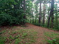
The Kutschenberg rises in the east of the Kmehlener Mountains. Its summit is located in Brandenburg in the municipality of Großkmehlen - 1.5 km south of the town of the same name and 2.5 km west-southwest of the town center of Ortrand . Beyond the state border in Saxony are the Lampertswald district of Blochwitz in the south-west and the Schönfeld district of Linz in the south-south-east. The federal motorway 13 runs past to the east . The elevation is wooded.
Mountain height
Recent altitude measurements in 2000 revealed that the Kutschenberg, at 201 m, is the highest mountain in the state of Brandenburg. In this regard, a small granite stele was set up on its heavily forested summit in 2011, which was only gently elevated above the surrounding area , on which one can read: “KUTSCHENBERG 201 m above sea level. NHN " . There is a trigonometric point near the summit at a height of 199.7 m .
The Heidehöhe , about 11 km west of Val Gardena , is at 201.4 m a little higher than the Kutschenberg, but is not considered the highest mountain, but the highest elevation in Brandenburg, as its associated summit, called Heideberg , is in Saxony. Contrary to the widespread opinion that the Hagelberg ( 200.24 m ) in Fläming is the highest mountain in Brandenburg, it is just surpassed by the Kutschenberg.
Am Kutschenberg race track
On the northeast slope of the Kutschenberg, about 400 m from the summit, there is the well-known off-road race track Am Kutschenberg , where car and motorcycle races take place regularly.
gallery

Summit of the Kutschenberg

Summit stele on the Kutschenberg
Summit plateau of the Kutschenberg

Ski hut on the Kutschenberg

Plot of the location and elevation plan on the Kutschenberg


Web links
Individual evidence
- ↑ a b c Photo of the stele with inscription on the Kutschenberg, on commons.wikimedia.org
- ↑ Excerpt from: Local history yearbook for the old district of Bad Liebenwerda, the Mückenberger Ländchen, Ortrand am Schraden, Falkenberg and Uebigau 2002 , p. 207 - Plot of the location and elevation plan on the Kutschenberg (reduction without scale; elevation system: DHHN 92, measured on May 12, 2000 by JR / JT), p. 210 - Letter confirming the measurements, signed by the director of the Brandenburg State Surveying Office . Published by the Arbeitsgemeinschaft für Heimatkunde e. V. (Bad Liebenwerda District Museum)
- ↑ Map services of the Federal Agency for Nature Conservation ( information )
- ↑ Autocross on Kutschenberg , on kutschenberg.de