Hagelberg
| Hagelberg | ||
|---|---|---|
|
Summit cross on the Hagelberg (with outdated height information) |
||
| height | 200.3 m above sea level NHN | |
| location | Brandenburg ( Germany ) | |
| Mountains | Flaming | |
| Dominance | 71.5 km → Petersberg | |
| Notch height | 112 m ↓ at Oehna | |
| Coordinates | 52 ° 8 ′ 19 ″ N , 12 ° 31 ′ 2 ″ E | |
|
|
||
| Type | Terminal moraine | |
| rock | Debris , sand , gravel | |
| Age of the rock |
Saale Ice Age (approx. 140,000 years) |
|
| particularities | highest elevation of the Fläming | |
Hagelberg refers to a mountain and a village in the Hoher Fläming Nature Park in Brandenburg . The village of Hagelberg is part of the district town of Bad Belzig in the Potsdam-Mittelmark district .
The Hagelberg lies within the boundaries of the village and is 200.3 m above sea level. NHN the highest elevation of the Fläming and the second highest mountain in Brandenburg. Contrary to the widespread opinion and as indicated on information boards on site that the Fläming with the Hagelberg is the highest area in Brandenburg, this is just exceeded by the Kutschenberg , which is only 5 meters from the border with Saxony in the Oberspreewald-Lausitz district .
The place and the mountain are best known for the so-called Kolbenschlacht of 1813 in the wars of liberation , in which Prussian soldiers and the newly created Landwehr as well as Russian Cossacks destroyed a French corps of 10,000 to 3,000 men in the run-up to the Battle of Leipzig . Two monuments and a large number of information boards commemorate this battle.
→ Main article: Battle of Hagelberg
The former Vorwerk Klein-Glien , which is about one kilometer south, belongs to the village . Hagelberg is traditionally oriented towards agriculture. Due to the historical sites and the natural integration into the landscape of the Hoher Fläming Nature Park, tourism is becoming increasingly important. Hagelberg (including Klein-Glien) has a total of around 175 inhabitants on an area of 14 km².
Location and traffic area
Hagelberg can only be reached via two small country roads. One road leads from the neighboring village in the west, the Wiesenburg district of Schmerwitz, two kilometers away , up to Hagelberg and ends there. The second road comes from the Vorwerk Klein-Glien or Borne and runs from Hagelberg over the Spitzberg further north to the village of Lübnitz , which follows after two kilometers and is on the connecting road Bad Belzig - Görzke . In Klein-Glien there is a connection to the federal highway 246 . The direct neighbor to the east is the town of Bad Belzig itself, which is only directly connected to Hagelberg by the European long-distance hiking trail E11 . The approximately four kilometer long path leads over the Hüttenberg through the Belziger Busch to the district town. There is no rail link, but Hagelberg is connected to the TVG Belzig bus network.
The Hagelberg
On the mountain, for occasionally the misspelling hail s mountain place and its surroundings, there are three prominent attractions / cultural sites at each different places:
- the mountain peak with an unobstructed panoramic view over the Fläming heights to the south and west and with a detailed information board about the battle of Hagelberg
- the old Hagelberg monument from 1849
- the new Hagelberg monument from 1955
Height and monuments
The Hagelberg was long considered the highest mountain in Brandenburg . For new survey in 2000 had, though extremely scarce, the order in favor of the mountains in the Lausitz : Heather Height (201.40 meters) and Kutschenberg (201 meters) to be changed. The sign with the inscription Hagelberg - highest point in the state of Brandenburg was then removed from its summit. The new summit cross from 2006 contains the inscription “201 meters” and thus the same height as the Kutschenberg, the exact measurement of 200.3 m above sea level. However, NHN assigns the Fläminggipfel the third altitude place.
The mountain peak with the summit cross, a summit book and a large information board about the battle is located at the entrance to the village from the direction of Klein-Glien on the west side, right next to the road, while the new Hagelberg monument from 1955 is opposite on the east side of the country road. The help of the Cossacks in the historic battle offered the GDR leadership a welcome opportunity to affirm the brotherhood in arms with the big brother Soviet Union in this second monument; the inscription reads: In memory of the German-Russian Brotherhood of Arms in the battle near Hagelberg on August 27, 1813 .
The old, today heavily modified Hagelberg monument by the sculptor August Julius Streichenberg , which King Friedrich Wilhelm IV inaugurated in 1849, shows on a central bronze plate created by the Berlin sculptor Martin Meyer-Pyritz the likeness of the Prussian general Karl Friedrich von Hirschfeld , who was in the Battle of 3000 Prussian soldiers and the initially much ridiculed Brandenburg Landwehr (Napoleon: Canaille ) commanded 8500 men. The south side bears the two-line inscription 27. August | Battle near Hagelberg and the boulder enthroned on the monument (instead of the Borussia originally located there) the engraving of the year 1813 . The old monument follows after around seven hundred meters on the west side of the road towards Lübnitz on a side hill. In addition, there are various signposts and signs on individual aspects of the battle, such as Franz's Retreat, scattered over the hills and the village . Troops towards Lübnitz , persecution from the Cossacks or battle of 1813, the cemetery wall and 8,500 militiamen (mostly farmers) attacked from here on 08/27/1813 at 14:00 .
Formation in the Saale Ice Age - overprinting in the Vistula Ice Age
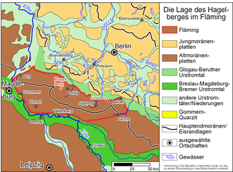
The Fläming ridge was piled up around 150,000 years ago by the glaciers of the penultimate Ice Age, the Saale Ice Age . The Hagelberg is part of a striking terminal moraine that runs in an east-west direction over the Fläming. It marks the limit of the southern extension of the glacier in the more recent advance phase of the Saale Ice Age (Warta stage). Furthermore, the Hagelberg is the highest elevation on the southern land ridge in Germany; only the continuation east of the Neisse in Poland reaches somewhat higher heights.
The last inland glaciation during the Vistula Ice Age around 21,000 years ago, on the other hand, only extended to the northern edge of the Fläming or the upstream Baruther glacial valley . Since the Fläming and Hagelberg remained ice-free, typical periglacial phenomena such as dry valleys ( rumble ) and wind canters formed under the cold climatic conditions of a frost debris tundra , which are very common in the vicinity of the Hagelberg.
The activity of the meltwater in the Baruther glacial valley, the southernmost and oldest of the three large glacial glacial valleys in Brandenburg, eroded in some places, such as on the southern edge of the Belziger landscape meadows , heavily on the northern slope of the Fläming, and cut out up to 60 meters of rising terrain. While the neighboring lowlands within the glacial valley already belong to the young moraine region of the Vistula Ice Age, the Hohe Fläming and the Hagelberg are still part of the old moraine landscape of the Saale Ice Age .
The thesis that is put forward now and then that the Fläming is tectonic and more like a rocky clod mountain range with a Variscan core can be considered refuted due to deep drilling. The layers of the Cretaceous and the Tertiary are located both under the Fläming and in its immediate vicinity at the same altitude and are therefore undisturbed.
Etymology - chabua, hawk, hail and clay
Mountain and place Hagelberg
The Slavic word Chabua , from which today's name Hagelberg was formed, did not originally designate the highest elevation of the ridge, but the Hohen Fläming as a whole, at least the Fläming in the area around the Hagelberg. In the first written note that has been handed down, a document from the year 1009, there is the phrase cum ... Chabua montibus . So we're talking about mountains . For Reinhard E. Fischer , the name is undoubtedly derived from the Slavic Chabov [… and…] denotes mountains overgrown with undergrowth, cf. Polish chabie 'undergrowth', chabina 'rod'. The village of Hagelberg got its name after the mountain.
The settlers from the German-speaking and Flemish regions, who came to Fläming in the course of the country's expansion in the 12th century, transformed the Slavic terms into familiar words. They put the unknown word Chabua to the bird name Habicht ( Middle Low German havek ), which was later added to Hagel .
When the v from havek ( hauesberge ) disappeared in the dialectic development and the subsequent dialect form Haalberg came closer and closer to the dialect of the river Havel = haale (and the city of Havelberg ), the Saxon authorities at the time replaced the vanished v with a g . With this, a clear demarcation was made in the official form of the name hyper-correct and with Hagel there was again a well-known term, which was also spoken in Middle Low German as Haal . There is no content-related relationship between hail and hail mountain.
According to the Slavic mountain name Chabua from 1009, the following place names have been handed down: 1385 czu hauesberge , 1419/20 hauelsberg , 1669 Hagelsberg , 1802 Hagelberg (dialect half - arch, Haalbärch ).
Vorwerk Klein Glien
The Slavic place name Glien occurs several times in Brandenburg and Mecklenburg-Western Pomerania and means a place where there is clay . East-northeast of Wiesenburg and south of Hagelberg, the former Groß-Glien and Klein-Glien are first recorded in writing in 1388: czum large Glyn and czum lutkin Glyn . It is not clear which of the two Glyns was the original Slavic settlement. Both villages were desolate by the time of the Hussite Wars at the latest , Groß-Glien in 1419/1420, and Klein-Glien in 1426/1427. For Groß-Glien the establishment of a sheep farm (1592 a sheep farm ) is recorded for 1554/1574, followed by a farm that was demolished in 1931. Since Groß-Glien has not existed since that time, the distinctive addition small is superfluous for the small-glien that still exists today, but is usually still added to the name.
For Klein-Glien, the sources record a Vorwerk in 1542, which was later supplemented by further buildings. In 1595 there is an entry Lüttichen Glien and in 1954 Glien is recorded as a district of Hagelberg. Reinhard E. Fischer specifies the dialect form with Kleen Jlien .
The two villages today
Since 1900, both villages have recorded an emigration of around 100 residents. If the current number is around 175 inhabitants, in 1900 there were still a total of 270 with the following distribution: Hagelberg 41, manor district Hagelberg 115, Klein-Glien 32, manor district Klein-Glien 82.
Hagelberg
As can be seen from the population figures from 1900, the goods and their agriculture determined the economic life of the villages. In addition to soft tourism (see section “Economic factor soft tourism” below), agriculture is still an important economic factor today.
The former Gut Hagelberg was managed from 1991 to 1999 by Synanon , an association for drug self-help, as part of its Synanon Gut Schmerwitz GmbH . Synanon had been rebuilding the extensive and neighboring Schmerwitz estate since 1991. In 2000 the Schmerwitz location was given up due to financial problems and the Schmerwitz estate was completely sold to a private investor. Synanon is now only represented in Berlin. The successor to the large Synanon project with 1,000 beds in Schmerwitz is a smaller self-help community with around 30 beds, the Scarabäus Hoher Fläming eV .
The Schmerwitz estate extends as far as Hagelberg and even part of the Hagelbergkuppe is part of it, but is not used. In Hagelberg, Synanon rehabilitated the manor and the pond that was previously contaminated with manure in the 1990s . Furthermore, the association built a large, modern cowshed, which has been managed since 2001 by "Gut Hagelberg GmbH & Co. KG".
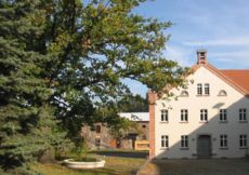
It is noteworthy that there was no church building in Hagelberg and still does not exist today. Services were allegedly held earlier in the manor building, which was completely renovated in 2006 (see picture). This building now serves as the apartment for the manager couple of the dairy farm. The new owners refrained from renovating the actual manor house for cost reasons.
Klein-Glien
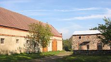
This former patronage church of the manor is now the parish church. Here, among others, the work and training promotion association Belzig e. V. responsible for the restoration of the old manor, from which a modern conference hotel with restaurant, farm shop and creative workshop (weaving and pottery courses) has emerged. The estate, farmyard and stable of the facility have been under monument protection since 1993 . In contrast to the town, the Glien estate does not have the addition of small .
In 1818, five years after the Battle of Hagelberg, Levin von Tschirschky took over the estate, built the house and moved into it in 1823. Tschirschky had an English park built around the estate , which is now restored according to the old model. His further improvements on the estate, in the village, on paths and avenues brought Klein-Glien the reputation of one of the most pleasant places in the area at this time . Tschirschky and his family must have gained considerable influence in the region for a century, as the following are listed as district administrators in the Zauch-Belzig district : 1828 Heinrich Friedrich Levin von Tschirschky and Bögendorff, 1852 Heinrich Otto Levin von Tschirschky and Bögendorff and 1898 Bernhard von Tschirschky and Bögendorff. The last owner of Gutshof Glien from the Tschirschky family, Dr. Fritz von Tschirschky and Boegendorf, the son of the latter, born in 1903, fell in September 1941 as first lieutenant in the Second World War in the Soviet Union.
On July 1, 1950, the previously independent municipality of Klein Glien (spelling at that time) was incorporated.
Economic factor soft tourism
Soft tourism is developing into an increasingly important economic factor in Hohen Fläming. With a very thin density of settlements, the nature park is a paradise for "quiet seekers" whose needs are met by a well-developed network of hiking and cycling trails. The European long-distance hiking trail E11 , which leads from the North Sea to the Masurian Lakes, continues via Klein-Glien and Hagelberg to Bad Belzig and is largely barrier-free here . Other paved paths, meadow paths and sand paths, sometimes with an open view over the gently rolling, low mountain range, sometimes in deep forests or on the edge of the forest, past hedges, fruit trees and fields, invite individual travelers to go hiking. There are no rushing streams or lakes in this part of the already arid Fläming.
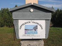
The Hoher Fläming Nature Park and other providers offer a wide range of organized, themed group excursions and hikes, ranging from boulder tours and herb hikes to nature discovery trails and village tours to the culinary potato tour in which Gutshof Glien takes part. The entrance to the Hoher Fläming Art Trail is on the road between Klein-Glien and Hagelberg . In 2006 eight artists, artist groups and a school class in Belzig created works of art around the Hagelberg from materials provided by the natural environment. Under the motto Landart, you will find works such as life after the Ice Age , trace of the stones , a view of pastures , forest and meadow sofas , stone snakes or labyrinths on a 2.5 km long circuit . On August 5, 2007, the Hoher Fläming art hiking trail was opened, which connects Bad Belzig and Wiesenburg and leads through Hagelberg. The work of art “Waterfall for the Fläming” was realized below the Hagelberg.
Even without the art trail and potato tour, the landscape and tranquility around the highest Fläming summit, its monuments and its historical significance are already a considerable attraction.
Footnotes
- ↑ a b Torsten Hampel: Markers who climb hills In: Der Tagesspiegel . June 7, 2015.
- ↑ On the thesis that goes back to Friedrich Solger , supported by Dieter Noeske, see for example: Gut Schmerwitz, Landschaftsästhetisches Hofportrait, chapter "Landschaftliche Eigenart" online ( Memento of the original from April 23, 2010 in the Internet Archive ) Info: The archive link became automatic used and not yet tested. Please check the original and archive link according to the instructions and then remove this notice. ; on icing etc. see literature atlas for the geology of Brandenburg
- ↑ Certificate No. 210 in: Harry Bresslau , Hermann Bloch , R. Holtzmann u. a. (Ed.): Diplomata 14: The documents of Heinrich II. And Arduins (Heinrici II. Et Arduini Diplomata). Hanover 1900–1903, pp. 246–248 ( Monumenta Germaniae Historica , digitized version )
- ↑ Fischer, Neuendorf, Reso ... p. 20
- ↑ Fischer, Neuendorf, Reso ... p. 19f
- ^ Fischer, Neuendorf, Reso ... p. 18
- ↑ Gemeindeververzeichnis.de 1900 online , the differentiation made here according to districts and then again according to manor district can no longer be found today.
- ↑ Immediate admission - Help for addicts, without preconditions Day & Night - SYNANON. In: www.synanon-aktuell.de. Retrieved June 3, 2016 .
- ↑ Inpatient facility | SCARABÄUS Hoher Fläming eV In: www.scarabaeus-schmerwitz.de. Retrieved June 3, 2016 .
- ↑ see above web link Landleben e. V.
- ^ Brandenburger Picnic, Gutshof Glien online
- ^ Zauch-Belzig district online
- ^ BRANDENBURG ad Havel (14776), (Knight Academy), Brandenburg. Retrieved July 4, 2016 .
- ↑ Klein Glien / Haus Glien - GenWiki. In: wiki-de.genealogy.net. Retrieved July 4, 2016 .
- ↑ Hoher Fläming Nature Park, Fläming Calendar, see entry on July 16, 2006 on the Kunstspur online ( Memento of the original from December 10, 2006 in the Internet Archive ) Info: The archive link was automatically inserted and not yet checked. Please check the original and archive link according to the instructions and then remove this notice.
literature
- Werner Stackebrandt and Volker Manhenke (eds.): Atlas for the geology of Brandenburg. State Office for Geosciences and Raw Materials Brandenburg (State Office for Mining, Geology and Raw Materials Brandenburg, LBGR) 2002, 2nd edition, 142 pages, 43 maps, ISBN 3-9808157-0-6 .
- Reinhard E. Fischer , Jürgen Neuendorf, Joachim Reso, Around Belzig. Place and field names, boulders and trees, streams and ponds. Publisher: Förderkreis Museum Burg Eisenhardt Belzig e. V., Book 4 on city history. No information on publisher, year, ISBN, the foreword is from 1997. On Hagelberg p. 19 f, on Klein-Glien p. 18.
- Reinhard E. Fischer, The place names of the states of Brandenburg and Berlin. Volume 13 of the Brandenburg Historical Studies. Commissioned by the Brandenburg Historical Commission, be.bra Wissenschaft verlag Berlin-Brandenburg 2005, ISBN 3-937233-30-X , ISSN 1860-2436 . On Hagelberg p. 73, on Klein-Glien p. 63.
- René Schreiter: The “Borussia” on the Hagelberg. A war memorial for the Wars of Liberation in the context of the revolution of 1848. In: Dieter Hübener et al. (Edit.), War memorials in Brandenburg. be.bra Verlag, Berlin 2003, pp. 175-184.


