Hasselbrack
| Hasselbrack | ||
|---|---|---|
|
Summit area of the Hasselbracks |
||
| height | 116.2 m above sea level NHN | |
| location | Hamburg , Lower Saxony ( Germany ) | |
| Mountains | Harburg Mountains | |
| Coordinates | 53 ° 25 '49 " N , 9 ° 51' 50" E | |
|
|
||
| particularities | highest elevation in Hamburg | |

The Hasselbrack in the Harburg mountains is 116.2 m above sea level. NHN the highest natural elevation in Hamburg and lies on the border with Lower Saxony .
geography
location
The Hasselbrack is located on the southern border between Hamburg and Lower Saxony in the Black Mountains , a northern foothill of the Harburg Mountains , in the south-southeast of the district of Neugraben-Fischbek . It is located in the Rosengarten state forest at the interface with the Daerstorfer Heide between the Waldfrieden settlement belonging to Fischbek in the north, Neu Wulmstorf- Tempelberg in the west and Rosengarten- Alvesen in the east.
Natural allocation
The Hasselbrack belongs to the natural spatial main unit group Lüneburg Heath (No. 64), the main unit Hohe Heide (640) and the sub-unit Wilseder terminal moraines (640.0) to the natural area Black Mountains (640.00).
Protected areas
North-northwest of the Hasselbracks on the Hamburg side is the nature reserve (NSG) Fischbeker Heide ( CDDA no. 4384; designated 1958; 7.62 km² in size), which extends to the summit region. It is designated as the Fauna-Flora-Habitat- Area Fischbeker Heide (CDDA No. 2525-301) and beech forests in the rose garden (CDDA No. 2525-302). On the Lower Saxony side there are parts of the Rosengarten – Kiekeberg – Stuvenwald landscape protection area (CDDA no. 323951; 1965; 58.68 km²).
summit
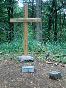
On the summit of the Hasselbrack there is a trigonometric point , which is only a few meters away from the hiking trail in the forest and marks the highest point. Since February 2009 there has been a summit book in a metal box, which has also been used as a geocache since 2011 . In 2011 a large wooden summit cross with the inscriptions Hasselbrack - 116.2 m and July 16 , 2011 was erected. In the spring of 2013, the Wanderfreunde Hamburg replaced the cross with a marker made of white granite ; its inscription reads: Hasselbrack, 116 m - the highest point in Hamburg . From Easter to October 2014 there was a simple wooden cross with no inscription next to the stone.
Traffic and walking
Because there are no roads over the Hasselbrack or just past it, it can only be reached from the surrounding villages on forest paths and paths. The European long-distance hiking trail E1 and the Heidschnuckenweg lead past a little to the west .
Web links
Individual evidence
- ↑ a b Height of the survey according to the Geological State Office Hamburg and until 2013 according to the inscription on the summit cross at that time
- ^ Sofie Meisel: Geographical land survey: The natural spatial units on sheet 57 Hamburg-Süd. Federal Institute for Regional Studies, Bad Godesberg 1964. → Online map (PDF; 4.4 MB)
- ↑ Map services of the Federal Agency for Nature Conservation ( information )

