
Geocaching

Geocaching (English [ 'dʒiːoʊ̯kæʃɪŋ ] ( ) or German [ ' geːokɛʃɪŋ ] ( ), derived from ancient Greek γῆ gē "earth" and English cache "hiding place, secret camp"), in German-speaking countries also GPS -Called a scavenger hunt , is a type of treasure hunt that began to spread at the end of the 20th century. The hiding spots ("Geocaches", in German [ 'geːokɛʃɘs ] ( ), in German for short " Caches " [ kɛʃəs ]) ( ) are published on the Internet based on geographic coordinates and can then be viewed using a GPS To be searched for. Alternatively, searches can also be carried out without a separate GPS receiver using precise maps or corresponding apps on the smartphone.
A geocache is usually a waterproof container that contains a logbook and, often, various small items for exchange. The visitor can enter himself into a log book to document his successful search. The geocache will then be hidden again in the place where it was previously found. The find can be noted on the Internet on the associated page and, if necessary, supplemented with photos. In this way, other people - especially the hiding person or owner - can follow what is going on around the geocache. It is essential in the entire search and exchange process that the project is not recognized by other people present and so the geocache remains hidden from uninitiated people. In the spring of 2019 there should be around three million participants in the varied game (called "Cacher") in many countries around the world.
history
The beginnings
Geocaching can be traced back to the much older letterboxing , in which containers are also hidden in different places, but which are then usually searched for without GPS support. The search is carried out using clues and a compass. In each case there is a special stamp with which you can note the find in your personal stamp book. Letterboxing has been shown to have existed in Dartmoor in southern England as early as 1854 and it is still very popular there.
Since the 1980s, the practice Nuuksion Metsäsissit in the area around Helsinki only with the help of a map and an accuracy of 10 meters also scavenger hunts , where containers were hidden or content. Then they gave the determined coordinates to friends who could use them to go on a treasure hunt. From the 1990s the GPS signal was used for the first time to improve the accuracy of the coordinates.
Beginning of the modern scavenger hunt
It was only when the US government switched off the artificial deterioration in accuracy ( selective availability ) of the GPS signal for non-military users on May 2, 2000, increasing it from approx. 100 meters to approx. 10 meters and thereby increasing the use of GPS devices practicable in private use. To celebrate this improvement, Dave Ulmer proposed on May 3, 2000 in the Usenet newsgroup sci.geo.satellite-nav under the title "The Great American GPS Stash Hunt" to start a worldwide game and use containers at special locations To hide exchange objects and a logbook. As rules he formulated "Get some stuff, leave some stuff" - "Take stuff out, leave stuff behind" and the keeping of a logbook in which the finder can register and document the exchange of objects.
The first geocache

On May 3, 2000, near the city of Portland , Oregon, at 45 ° 17 ′ 27.6 ″ N , 122 ° 24 ′ 48 ″ W , Ulmer buried a black plastic bucket in which he had CDs, a video cassette, deposited a dollar bill, a book, a slingshot, and a tin of beans. He then published the coordinates of the hiding place in the newsgroup. Within a day of its publication, the stash (English "secret hiding place", "secret warehouse") was the first to be found by Mike Teague. Three days later, he created a private website on which he documented the growing number of stashes and their coordinates.
Ulmer's original stash was later badly damaged and no longer exists in its original form. To commemorate this, a new geocache and a memorial plaque were placed in the same location in 2001. During the preparations for the cementing of the memorial plaque, the old tin can was found on site, which had been an object of exchange in the first stash. This is now shown as a travel bug at geocaching events.
On May 30, 2000, the term geocaching was first suggested in a newsgroup to avoid negative associations with the word stash . On September 2, 2000, Jeremy Irish announced in this newsgroup that he had created his own website for listing geocaches at Geocaching.com. This took over all previous entries from the old page, which Mike Teague could not update for reasons of time.
Worldwide distribution
According to the database of what is now the largest geocache directory, Geocaching.com, there are now over 3 million active geocaches worldwide. There is at least one hidden geocache in almost every state on earth . Exceptions are currently North Korea , Somalia and Equatorial Guinea . The only active one outside of the earth is on the international space station (ISS).
The USA has the most geocaches with over 1 million (as of September 2017). There are over 367,000 geocaches in Germany, over 48,000 in Austria and over 31,000 in Switzerland . The fewest geocaches are in North Korea and Somalia with 0 each.
The largest geocache per capita distribution in January 2007 was in the Nordic countries Sweden , Norway , Finland and Denmark .
Germany
The first geocache in Germany was hidden on October 2, 2000 by the geocacher Ferenc south of Berlin in Brandenburg . It was called First Germany and has now been archived. With over 56,000 pieces, most of the geocaches are currently in North Rhine-Westphalia . The greatest geocache density is around 4.4 geocaches / km² in Berlin and around 3.6 geocaches / km² in Hamburg (as of September 2017). In absolute terms, Germany is the country with the highest number of geocaches after the USA.
Austria
The first Austrian geocache was called Austria's First . This is also archived in the meantime; a newly published geocache reminds of him today at the same coordinates. With over 10,900, most of the geocaches can be found in Lower Austria ; With over 2,400 geocaches, Vienna has the largest geocache density of approx. 5.8 geocaches / km² in Austria (as of September 2017).
Switzerland
There are almost 31,000 geocaches in Switzerland, most of them in the agglomeration areas of the Central Plateau and in the urban area.
The geocache


A geocache is ideally a solid, watertight sealable container that can protect the contents from external influences. The container itself can have different shapes, from a small film can to a simple plastic freshness box or Tupperware box to an ammunition box made of steel or a hidden safe, the combination of which has to be found out. Often the size of the container is determined by the location of the hiding place. The following size classification has been established for the geocache containers:
- Nano
- Tiny container, usually less than 1 cm in diameter, which only contains a small piece of paper as a logbook. Often magnetic so that it can be hidden inconspicuously on monuments or the like. According to Geocaching.com, nanos represent a sub-form of micro-geocaches. Nevertheless, some geocache owners choose the size designation “Other” for nanos and then give the details of the size in the listing. At opencaching.de "Nano" is an independent cache size.
- Micro or Mini
- Very small containers that often only contain a piece of paper and a pen. Often film cans or PET blanks ("PETlinge") are used.
- Small
- Small containers that offer space for smaller items in addition to a logbook.
- normal
- Medium-sized geocache that offers space for multiple trackables or barter items. Containers of this size can hold from one to several liters.
- Large
- Large containers that offer a maximum of space and can therefore hold unusual exchange objects.
The owner specifies the size of the geocache when creating the listing. When searching for the geocache, it is helpful to know the size of the geocache because, depending on the specified size, any hiding places can be excluded.
.JPG)
In addition to the logbook, the container mostly contains items for exchange. If a geocache has been found, the finder can remove one or more of the items it contains and store something else for exchange. This exchange (trading) is then noted in the logbook and on the associated website. There is no compulsion to exchange; With some geocaches (for example the size micro ) there is no possibility of this due to lack of space. However, the principle of trade up, trade equal, or don't trade always applies when swapping ; that is, the objects removed and brought in should have a similar value ratio. If the value of the items removed clearly exceeds that of those left behind, this is referred to as downtrade or downtrading and is largely frowned upon - in contrast to uptrading or uptrading , i.e. leaving a higher-value exchange item behind. If you don't have anything suitable to swap, it makes sense to refrain from swapping. Likewise, it does not make sense to leave food, otherwise perishable goods or, for example, time-limited vouchers, as some caches are rarely found and food attracts animals. Since families with children also go on “treasure hunts”, objects that are not approved for young people are also taboo.
Every geocache should contain a kind of “ instructions for use ” (stash note) as basic equipment , so that any chance finders know what the container is about and thus do not regard it as garbage or a threat.
Trackables

In addition to everyday barter items, there are so-called trackables . These are taken from geocache to geocache by geocachers. At geocaching events, trackables are also passed on from one geocacher to another. Trackables usually have a specific goal. For example, a trackable should only be in a certain country, reach a certain destination, preferably only be stored in certain places or travel as far as possible.
Based on the geocaches in which a trackable is stored, the distance that the trackable has traveled is calculated as the crow flies.
Each trackable can be identified by a unique combination of digits or numbers.
Travel bug

The travel bug (from English "bitten by the travel bug" for "packed with travel bug") was the first type of trackable . The most common variant is similar to the shape of a military "dog tags" ( dog tag ). This is chained to any object by the owner of the trackable; Travel bugs are now also available as stickers (e.g. for vehicles) or as patches for items of clothing or rucksacks.
Geocoins
Geocoins are medals in different sizes and designs. Although geocoins are often sent on the road, they are mostly found as collectibles and trophies. Most geocoins are in the owner's inventory and can be logged by other geocachers when they are sighted, for example at events, with a special log entry (Discovered) .
Geocoins are also popular gifts between geocachers for certain goals that have been achieved, for example the milestone “1000 geocaching finds” or for a birthday. Often they are also personal mementos for participating in special events such as mega or giga events.
Other variants
Since Geocaching.com trackables can only be registered by purchasing them for a fee, free alternatives such as Geokretys (from Greek γη, [ geo- ] "earth" and Polish -krety for "mole") were created, where every user can use the Can create identification number itself. However, due to the lack of support from Geocaching.com, these alternatives are not widely used.
Hideouts and variants


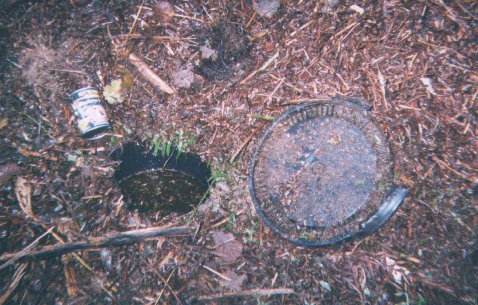
Out of consideration for nature, burying geocaches is undesirable and is expressly prohibited in the game rules of Geocaching.com . The digging of pipes, the camouflaged cover of which can then be removed by the finder without digging tools, is also prohibited by Geocaching.com. Therefore, existing natural or artificial cavities are used as hiding places: small caves, niches between rocks or tree roots, cracks in walls, old buildings and the like. In order to reduce the risk of accidental finds and to make the search more difficult, hiding places close to the ground are usually camouflaged with leaves, bark, moss, stones or twigs. Particularly ingenious hiding spots include film cans sunk into specially made holes, labeled magnetic foils, information on walls, rocks, under the seats of park benches and in the cracks of display boards. Geocaches can also be stored in former switch boxes, on fishing strings, in pipe rods or under water.
Geocaches are usually rated according to the degree of difficulty of the route and the terrain (Terrain) and the degree of difficulty of the tasks (Difficulty) in order to indicate the approximate effort required for the search. Geocaches can require you to carry special equipment (from a simple flashlight to climbing, mountaineering or diving equipment or a boat), solve puzzles or arithmetic tasks, climb trees or explore grottos and caves .
Geocaches can be divided into different categories based on their task, the most important of which are:
- The "simple" geocache (traditional geocaches) , in which the position of the hiding place is indicated directly.
- Multi-level geocaches (multi-caches or offset caches) , in which you have to go to several locations with information on the next location or the actual hiding place.
- Riddle caches (mystery caches) that require research or puzzling in advance.
- Virtual caches (Virtual Cache) in which neither container nor a logbook are present, are the most common here is the Earth caches that indicate specific geological phenomena.
Traditional geocache
The first geocaches belonged to this category, hence the name traditional geocache . They were initially hidden in special places, but now practically everywhere, including in urban areas. It is the most common type of geocache.
With this type of geocache, the coordinates of the hiding place are published directly. However, finding it can be difficult because there is good camouflage, the final is difficult to reach and requires mountaineering or diving, for example, special skill is required for the rescue or the place is smuggled .
Traditional geocaches that can be reached and found quickly by car are known as drive-in or park and grab geocaches.

Multi-cache
With a multi-cache , several “stations” (stages) have to be completed in order to find the hiding place. The coordinates of the finals result mostly from clues that the geocacher finds at the individual stations. The notices can be attached specifically for the geocache, for example by sticking the back of traffic signs, or result from the inclusion of things that are already available outside.
The difficulty depends on the tasks to be solved, on the clues to be found and on the final itself. The length and nature of the route determine the terrain assessment.
Event cache
An event cache (short form: event ) is an event that begins at a certain point in time and represents the social aspect of geocaching. It is a meeting of geocachers who share their common hobby. Event caches are often also meetings of geocachers with a regular meeting place .
Groundspeak, as the operator of the largest geocaching platform Geocaching.com, defines an event cache with more than 500 participants as a mega event cache . These events usually take place annually and also attract international visitors. In 2014, Groundspeak introduced the new Geocache-Art Giga-Event on the occasion of the enormous number of registrations for the "Mia san Mega" event in Munich , whereupon the event was renamed "Mia san Giga". It is defined by a number of participants of over 5000 people. The largest geocaching event in the world to date was the Giga-Event in Xanten 2015 with almost 13,000 participants.
A special form of event cache is the cache in - trash out (CITO). Garbage is collected and disposed of in a specific area. Usually a new geocache is laid out in this context. CITOs often take place in spring or autumn.
Event caches often generate ideas for new, sophisticated geocaches, as geocachers from the region meet and discuss together. Even beginners can familiarize themselves with the topic at event caches and benefit from tips from those present. Geocachers can get to know each other personally and exchange contact details in order to be able to contact a finder or the owner himself later during geocaching tours via mobile phone ("telephone joker"). To what extent this is in the spirit of the game is controversial in the community.
Puzzle cache
In the case of a puzzle cache (also known as a puzzle cache or mystery cache ), a puzzle must first be solved before the search for the final can begin. The coordinates published on the Internet therefore do not correspond to the actual information, but point to an arbitrary point that is of no significance for the search and is only used for illustration on the map. However, this should be nearby (a maximum of three kilometers away) so that the geocache can be correctly assigned regionally.
The puzzles can be of very different types and levels of difficulty (mathematical puzzles, trigonometric problems, literature problems, internet research, sudokus, picture puzzles, decoding, etc.). The determined coordinates are either the final itself (as with the traditional geocache) or the beginning of a multi-cache.
A bonus cache is a puzzle cache in which the preparatory work consists of finding one or more other geocaches, in which one receives the information about the entry or parts of the final coordinates in various other geocaches. In contrast to a regular mystery, it can be searched for without any preparatory work after finding the geocaches presented. Here, too, the published coordinates only point to an illustrative point in the area.
Challenge cache
The challenge cache is a special form of a puzzle cache in which a geocacher has to fulfill one or more geocaching-related qualifications before the geocache can be logged. When creating such a geocache, very special conditions apply.
Examples:
- Find four different types of geocaches in four different countries.
- Find a geocache in each state.
- Find at least five different types of geocaches in one day.
Challenge caches can be recognized by the addition "[Challenge]" in the title of the listing.
Night cache (NC)

A night cache is not a separate type of geocache, but a special form of the categories mentioned above. An NC is usually designed as a multi-cache or (multi) puzzle cache, but can also be designed in the respective traditional form. This type of geocache is often identified with a "[NC]" in the title of the listing. A night cache can only be found in the dark. The stations or the final have reflectors , flashing LEDs , acoustic signal generators, light barriers, alarm clocks or other technical gadgets. Some night caches require special devices such as night vision devices , metal detectors , radios or a UV light to find the clues.
Geocaches without containers

Geocaches without a container and logbook are virtual geocaches , webcam caches , reverse caches , adventure labs and earth caches . It is controversial in the geocacher community whether hiding and searching for such geocaches should really be seen as part of this hobby. With the exception of EarthCaches , these geocaches are generally no longer activated on Geocaching.com, but they are permitted on Opencaching.de . In 2017, Groundspeak gave 4000 selected geocachers worldwide the opportunity to publish a new virtual geocache on Geocaching.com. Another 4,000 members were given the opportunity in 2019. Such virtual geocaches that do not require a GPS device and can be completed "from home" have nothing to do with the original idea of geocaching and are therefore not viewed by many as geocaching .
In the case of webcam caches , the find is documented by a webcam photo taken by the finder. Occasionally, additional tasks have to be performed or utensils are required so that the finder can be recognized on the screenshot .
With reverse geocaches (German: "backward geocaches") you did not have to look for a container at a location for which you had the coordinates, but vice versa post the coordinates of a location for a given topic, for example the grave of a well-known personality. This type of geocache was abolished by Groundspeak in 2005 and not protected as a grandfather; all listings of this type are blocked. However, logged backward geocaches are retained in the statistics. A comparable type of cache exists at opencaching.de under the term Safari cache .
AdventureLabs are found via an external app. To log the cache, the geocacher has to enter an answer in a corresponding field. This must be found on site. The answer option is often localized and can only be entered within a certain radius of the coordinates. Selected experienced geocachers were given the opportunity to create a limited number of AdventureLabs. There should be new AdventureLabs temporarily for mega and giga events, and business partners should also have the opportunity to create such caches.
EarthCaches lead the geocachers to geologically interesting places where they can learn something about the formation, structure and shapes of the earth's crust and its different types of rock. On Geocaching.com they are an independent type of geocache, which can be designed in the form of a traditional geocache with unique coordinates or a multi. The concept of EarthCaches was developed by Gary Lewis of the Geological Society of America .
The first EarthCache was laid on January 10, 2004 in Australia. EarthCaches are checked by special reviewers , the Geoawares , before they are activated . Abbreviations in their names such as "GeoawareUSA" reveal the area of responsibility of the reviewer. The reviewers responsible for the German-speaking area are numbered “GeoawareDE”. To log an EarthCache , the geocacher must answer various questions about the geological topic presented and send them to the owner.
Wherigo cache
Wherigo .com (derived from English where I go , German roughly: "Where I go") is a platform for GPS-supported adventures in reality and since spring 2008 a new type of cache on Geocaching.com. The GPS guides players who load a so-called cartridge onto their GPS device - for example a PDA , older models from the Garmin Oregon series or Android , iOS or Symbian devices - to a desired location from the they can then interact with virtual objects and characters. The possibilities of Wherigos are very extensive. For example, when approaching individual locations, you can display certain images or texts with tasks or play sounds. A wherigo is particularly attractive in cases where not only linear processes are displayed, but the user can decide in which order he visits individual stations. The main work at Wherigos is to program the cartridge. The creation takes place on the PC. This requires special software that also offers a simulation environment.
Letterbox hybrid
Letterbox hybrids are a throwback to letterboxing , which is an ancient type of scavenger hunt. With letterboxing, you have to find a box based on directions, the so-called letterbox. There you stamp yourself in with your own stamp. There are also stamps in the cans whose imprints can be collected. Every letterbox listed on geocaching.com must also contain a stamp and a logbook. As with any geocache, GPS must be used at least once. Letterbox hybrids can also contain classic directions. Except for the stamp it is otherwise like a normal traditional, multi or puzzle cache.
Challenges (not to be confused with challenge caches )
The basic idea behind the challenges available on Geocaching.com from August 2011 was "to go somewhere and do something". This was completely independent of the containers and logbooks hidden in the cache types above. At the start of this game variant, premium members on Geocaching.com could create two different types of challenges . An action challenge had to perform a specific task in a specific location, such as singing a song in a large square or climbing the steps to the top of a tower. In a photo challenge , the participants had to take a photo of themselves in a special place, for example next to a monument or in front of a street sign.
The challenges published without a review process could be accepted by geocachers and later logged as "completed". You could search for existing challenges nearby or take part in global challenges. The challenges were recorded separately in the statistics and did not count towards the total score of the caches.
In December 2012, Groundspeak announced that the challenges would be discontinued immediately. The entire function was not placed under grandfathering, but was completely removed from the system in 2012; today there are no longer any references to challenges online. As an alternative, the challenge cache , a sub-category of the puzzle cache with a compelling reference to geocaching targets, was introduced.
Others
Geocaches on properties that are referred to in the community with the pseudo-Anglicism Lost Place (LP for short) do not represent a separate geocache type, but refer to the special features of the hiding place. Unused buildings are included in the treasure hunt, often in connection with background stories. So it can be that you look like Indiana Jones in old ruins or solve a fictional murder in an abandoned factory. Some of these places are old bunkers in the forest or entire abandoned villages . Since unused buildings and land usually have an owner in Germany, placing a geocache there or entering it can be a criminal offense under Section 123 StGB ( trespassing ), provided that the property is pacified and the owner does not has previously given his consent. For this reason, lost place geocaches are controversial in the community.
A special feature of all geocache types with a container as a final can be that it is secured with a lock that must be opened by lock picking .
The Hardcore caching (HCC) includes geocaches whose terrain and difficulty are ranked high (greater than or equal to Geocaching.com "four out of five stars"). Reaching these geocaches places special demands on the geocacher, be it solving difficult puzzles such as decoding encrypted information or physical challenges. Finding a hardcore cache usually takes several hours to days and often requires special equipment, for example for climbing or diving.
A moving cache is a geocache that is taken by the finder and hidden in another location. The coordinates of the old hiding place are replaced by those of the new one. Two rarer variants are, on the one hand, wearing a moving cache when you are out and about . Here the possibility is given to follow the position of the geocache live on the Internet, on the other hand there are moving caches that can be found in other geocaches and taken with you and placed in another geocache during a further search. The latter variant is similar to the principle of a trackable . Moving caches of any kind are not permitted on Geocaching.com, but are possible with other providers. There are also moving caches that are created as an open source project , so to speak . The owner puts the identifier with which he has placed the moving cache in a geocache and specifies rules by means of which a finder can seize the treasure and change it or move it to another location.
Another subspecies, which is also called reverse geocache , is a mixture of a mystery cache and a wherigo (see above). With a reverse geocache , the player receives the geocache right at the beginning of his search. The geocache, however, is locked and can only be opened when the player brings the cache to the previously determined destination. For this purpose, the reverse geocache independently determines its position with the help of a built-in GPS receiver. The first reverse geocache was built by Mikael Hart in 2009 and given away for a wedding. With this project, the inventor achieved a lot of media coverage. There are now some replicas of Hart's project that expand the scope of the original geocache with additional functions and puzzles that the player must first solve before the geocache reveals its content. The geocache known as "Captain Herrmano's Mystery Box" reacts to temperature, carbon monoxide concentration and the approach of the player, among other things.
Geocache databases
The rapid spread of geocaching and the growing number of geocaches quickly made it necessary to catalog them in a common database and make them available to users via the Internet. The best known and most extensive database is Geocaching.com , which has existed since September 2000 and contains more than 3 million geocaches worldwide (as of May 2017). Other geocache databases are Navicache.com , Opencaching.de or Terracaching.com . There are also country-specific geocaching portals such as Geocaching.de , which is a pure information site without a database, or Geocache.ch .
Publishing new geocaches
Geocaching.com
The geocaching database Geocaching.com has a mandatory review process that every listing must go through. A reviewer responsible for a region checks the information that the owner makes available online in connection with a geocache for compliance with the rules of the game and specifications for new listings. There is no check of the container on site, but a formal assessment of the listing. If facts can be identified from this that indicate a violation of the guidelines, the reviewer in charge contacts the owner to clarify the points in question before publication.
The main points are:
- Compliance with the requirements for certain areas such as nature reserves
- Compliance with the minimum distances to other geocaches or their relevant stations
- Correct classification of the geocache type and the specification of the container size
- Compliance with the requirements for listings with a focus on commercial content
- Compliance with rules regarding the finals of geocaches, such as proximity to railway facilities
- Removal of unauthorized internet links in listings
and a few more points.
Only then can the listing be published by the reviewer (“Publishing”) . In the event of disagreements between the reviewer and the owner of the geocache, each owner is free to contact the database operator's own office to have the matter finally clarified there ("Appeals") .
Other databases
The platform “Opencaching.pl” and some other open caching sites (but not “ Opencaching.de ”) also have an upstream checking process for new listings. Other platforms only check after they have been published or work on an ad hoc basis and only react when corresponding information is received from the community or there are external complaints.
Opportunities to evaluate listings and geocaches
The evaluation of a geocache, for example the attractiveness of the area or the creativity of the hiding place, is possible in different ways, but is mostly done directly through appropriate statements in the log entries. At Geocaching.com , premium members can also award “favorite points” for listings. One favorite point can be assigned for every ten geocaches logged as a "find".
In addition to the database's own evaluation methods, there are also independent methods. The “GCVote” plug-in for common browsers or clients such as “GSAK” , “c: geo” (Android app) or “Looking4Cache” (iOS app) displays buttons in listings to open the respective geocache on a To be able to rate a scale from 1 to 5 or to call up the average rating.
The evaluations are not made according to clear guidelines, are purely subjective and should therefore only be used with appropriate care for the evaluation of a listing and the associated geocache. Some owners speak out against an external rating with a banner or can also have their geocaches blocked for rating at "GCVote" . Geocaching.com prohibits the inclusion of "GCVote" in listings on this platform.
equipment
GPS receiver


To find geocaches you need a device with a GPS receiver . The use of topographic maps can facilitate orientation in the terrain, while road maps and routing functions facilitate the journey to the target area.
In addition to handheld GPS devices, notebooks , PDAs , mobile navigation systems and smartphones with integrated or external GPS receivers are alternative devices that are suitable for geocaching purposes. However, they are less designed for the requirements of demanding geocaches than GPS devices, which have long battery life and are protected against stress from bumps and rain.
In open terrain or on water, GPS devices can determine the position very precisely. In densely leafy forests, in ravines or between house facades in cities, older GPS devices in particular have difficulties in determining the position with sufficient accuracy. However, the further development of the devices is also steadily improving reception under difficult conditions.
software
Various software solutions facilitate the exercise of the hobby, but are not a requirement. This allows geocaches and their listings to be better managed, filtered according to various criteria and saved on portable systems such as PDAs or smartphones. This means that there is no need to print out the listings (keyword: "paperless geocaching").
camouflage

Geocaches are usually hidden and camouflaged in such a way that they cannot be found or recognized by uninvolved people. In addition, the principle applies to keep geocache hiding places as secret as possible and to visit them unobserved. Otherwise, there is a risk that the geocache could be damaged or lost by third parties.
Outsiders who are no other players are, as "Muggles" (English muggles called). The term comes from the Harry Potter books , where "Muggles" are used to denote "people without magical abilities".
Problems and criticism
Legal problems
For reasons of nature conservation , it can become problematic if geocaching leads people into areas that were previously largely untouched or protected, whereby animals and plants can be disturbed. In addition, placing and searching for geocaches can lead to legal problems under certain circumstances, especially if the hiding places are private property. Everyone is allowed to enter open landscapes and forests; However, if it is a nature reserve, it must not be damaged or changed. According to most nature reserve ordinances, this also includes the ban on leaving the paths in the respective area. There is also such a ban in the national parks, which is usually stipulated in the applicable state law. Neither laying out nor searching for geocaches off the beaten track is therefore not permitted.
Particularly protected biotopes and geotopes, including places of particular interest for geocaching such as caves, reed beds , moors or alluvial forests , are prohibited from destruction or other significant impairment . This is the case, for example, with a threat to the habitat of an animal or plant species, which can quickly be the case depending on the sensitivity of the natural area. It is therefore advisable to refrain from geocaching in such biotopes in case of doubt. In addition, it is illegal to significantly disrupt protected wild animals in the hibernation phase and thereby worsen the conservation status of the local population of a species . The loss of energy during frequent awakening due to disturbances can lead to the death of animals. As part of the cave protection , signs are already being installed at cave entrances in the Franconian Alb area, which expressly prohibit the laying out of geocaches.
Winter roosts for bats are specially protected between October 1st and March 31st, and visiting them for geocaching purposes is prohibited during this time. Negative changes in these areas of life have already been demonstrated in this context. Owner, their geocaches on Geocaching.com lists are therefore invited to submit their caches for the duration of Bat Conservation time to remove and their status to "off" (disabled) to set so that they are not part of the game are the relevant period. If a reviewer notices that a cave geocache is not marked as "deactivated", the geocache can be "archived" by him. After intensive discussion, no new cave caches have been activated by the reviewers of Geocaching.com since 2011, at least in Franconia .
There are also regular disturbances at breeding grounds for birds. In Hesse, geocaches were found in 66 of the 229 eagle owl breeding sites in the immediate vicinity or in individual cases even at the breeding site itself. In the Eifel , an average of only 1.2 young birds per brood in protected areas for nature, while quarries with rock extraction there are on average 2 young birds per brood. Geocaching is also held responsible for this. In the Eifel, conservationists now regularly check geocaching platforms for problematic listings. In the case of critical geocaches, archiving is then worked towards.
Geocaches in the vicinity of former war zones (e.g. the Hürtgenwald , which was fought over in World War II ), military training areas and shooting ranges are also problematic , as there is a high risk of running into live ammunition when searching for the geocache can lead to life-threatening injuries. Since unauthorized persons are not allowed to enter such restricted areas , the storage of the cache is already prohibited by the authorities.
Other problems and dangers
Extreme and difficult geocache hiding spots or parts of the search can pose a security risk to geocachers. The hazard potential of bunkers, mine tunnels, caves, sewers, abandoned buildings, climbing sections or steep walls is not always obvious or is misjudged by inexperienced people. Although a degree of difficulty is given for each geocache is in this merely an assessment of the investing Owners . You can only find out about undetected danger spots in advance from the comments of other geocachers, whose experience in turn does not have to match that of the interested party. Furthermore, geocachers can put themselves in danger by overestimating themselves . Even if accidents are very rare, over the years there have been several that are directly related to the hiding of the geocaches. In 2011, one of the most experienced geocachers in Germany at the time had a fatal accident while attempting to recover a geocache attached to the bridge of a district heating pipe. The geocache at this bridge was only marked with an overall difficulty of 2 and terrain difficulty of 3.5. In 2015, another geocache, which was fastened with magnets at a height of 35 meters under the bridge of a motorway slip road, was removed at the instigation of the responsible authorities. On June 6, 2018, two geocachers died while searching for a geocache in a storm sewer in Prague when a thunderstorm hit the city.
Geocaches can be mistakenly mistaken for a threat by innocent bystanders, suspected of being a terrorist background. Examples are the alleged discovery of an "ammunition case", the four-hour lock of a sluice due to suspected bombs, an elaborate police and fire brigade operation because of an "unknown device" on a street lamp as well as bomb warnings with subsequent police operations on the motorway near Erlangen in downtown Wiesbaden and in 2011 in Wetherby in the UK , where an entire street was evacuated for several hours. The owner's notices and contact information posted on the outside of the geocache container can help prevent such misunderstandings.
The geocacher himself can also appear suspicious to bystanders if he searches for the geocache in an unobtrusive way, finds it and hides it again. For example, the police in Bremen already stepped in when there was suspicion of drug trafficking through a conspiratorial drug stash. Nevertheless, such police operations are exceptions and usually have no consequences for geocachers, especially since the proportion of geocaching police officers is increasing and there is also a close exchange of information between the platform operators and the various police authorities.
Geocaching in hunting grounds can - like any other hike in the forest - endanger both hunting and the geocacher himself. Especially in twilight and in the dark there is a risk of not being recognized and being mistaken for game. For this reason, night caches in particular are criticized by game overseers and hunters. In any case, however, a hunter may only shoot if he has addressed the target beforehand , i. H. when he has clearly determined the species, sex and, in some cases, age.
The geocachers themselves have already become aware of the nature conservation problem, as shown by regular educational events, events, information stands at mega and giga events and conferences on these topics.
The increasing popularity and the associated rapidly growing number of hidden geocaches is the subject of controversy within the geocaching community, as the game no longer takes place "in secret". At the same time, Geocaching.com, as a for-profit company, has a commercial interest in increasing the number of “premium members” and is therefore constantly trying to promote the game's popularity.
Powertrails must also be mentioned in this context . Many geocaches have been laid out within as short a distance as possible. They sometimes lead to mass rushes of geocachers who want to book as many finds as possible in the shortest possible time, which can also cause visible damage to nature.
Related topics
Similar leisure activities with an emphasis on the aspect of competition are geodashing , the "Geograph -Project" and the finding of confluence points . The game "GPS-Challenge" is again geared more towards the idea of competition , in which the aim is to run or drive waypoints using GPS receivers in the shortest possible time (race) . Geocaching can also be combined with " bookcrossing ". Another variant is waymarking, another Groundspeak project . The aim is to track down interesting places in nature such as mountain peaks or in the surrounding area such as special buildings, to take photos, to determine the coordinates of each and to create a description page that resembles a " point of interest " . However, less specific points such as specialty restaurants can also be logged. When Geohashing it comes to reach a randomly determined daily point on this date.
The game Munzee is only aimed at smartphone users . Here are QR codes instead of cans hidden, and by scanning the player receives points on his account credited. Scanning in the vicinity of the stored coordinates is required; the app required for the game checks the geographic coordinates when scanning.
The Actionbound app is also for smartphone and tablet users . Users can create and play their own multi-caches or access public caches.
The game Sighter is also aimed at smartphone users , and things have to be compared in the same GPS positions as stored in a photo.
The term ' location-based games ' is also used as an umbrella term for position-based games that use mobile devices and technologies such as GPS .
The much older letterboxing , which has its origins in Dartmoor in southern England , is understood as a "historical model" of geocaching. Here, too, it is a matter of searching for hidden containers on the basis of clues, which, however, are often located without the aid of precise coordinates, but on the basis of descriptions and a compass . A special feature of letterboxing is that there is an individual stamp in each container, the imprint of which you collect in your own stamp book or each finder leaves the imprint of his stamp in the logbook of the respective letterbox.
Geocacher glossary
Geocachers use their own jargon when practicing their hobby. The following terms (in alphabetical order) are often used:
| term | Explanation |
|---|---|
| +1 | In the log entry of a finder, usually an expression of disappointment about a geocache that is perceived as very uninteresting, which is viewed as a statistical point. |
| Base zone | Groundspeak - term for the area around the place of residence of a geocacher. |
| Better hiding place | A geocacher who places the container in a different, supposedly “better” place or camouflages it more extensively than originally intended by the owner. |
| BWW | (Letter word value ) The letters are assigned natural numbers in the order of the alphabet, i.e. A = 1, B = 2, C = 3, etc. |
| BYOP | (Bring your own pen) Bring your own pen , as the box may be too small to store a pen in. |
| Cacher freeway | Clearly visible trails that arise unintentionally when many geocachers always take the same route to a hiding place. Often a “cache highway” in the target area leads directly to the final. |
| CITO | (Cache in Trash out) Initiative to free nature from rubbish while geocaching (see above). |
| CO | (Cache owner) → see owner |
| DFDC | Formula for logging: Thanks for the cache. , corresponds to the acronym "TFTC" ( Thank you for the cache. ). |
| DFDR | Formula for logging: Thanks for the puzzle. , corresponds to the acronym "TFTM" (English. Thank you for the mystery. ). |
| DNF | (Did Not Find) , geocache not found |
| E (G) CA | Extended (geo-) cacher equipment (e.g. UV lamp, gripper, telescope magnet and other aids) |
| AGV | (First To Find) First finder of a newly published geocache |
| FTL | (First To Lose) A self-deprecating or bitter term for an → STF that occurs under “FTF hunters” if the FTF was just missed. |
| FP | Favorite point (can be awarded by premium members once for every 10 caches found). |
| GZ | (Ground Zero) The point that comes closest to the coordinates shown on the GPS receiver and the coordinates from the listing. |
| Rabbit grill | Conspicuous, for geocachers immediately visible camouflage of a geocache through overlying branches. |
| Hint | (English for "hint") More or less direct tip to a hiding place, a station or the solution to a puzzle |
| Home zone | → Base zone |
| Muggle, Muggle | Non-geocacher (see above) |
| ROT13 | A simple coding method in which letters are shifted by 13 positions, for example to prevent accidentally reading through a → hint. |
| Owner | (Owner) The person who hid a geocache or owns a trackable. |
| Powertrail | Series of geocaches that are close together (see above). |
| Sissicacher | Geocacher who doesn't like to get dirty in the field. |
| spoiler | (English for Verderber ) A description or a photo that makes it easier to find the cache or solve a puzzle cache. |
| STF | (Second to find) Second finder of a newly published geocache. |
| TB | (Travel-Bug) Metal tag with an individual number, the route of which can be traced on Geocaching.com (see above). |
| TFTC | ( Thank you for the cache ) Formula for logging (Thanks for the cache.) . |
| Trauma cache | Geocache that cannot be found for a long time and despite several attempts. |
| TTF | (Third to find) Third party finder of a newly published geocache. |
| TNLN | (Took nothing, left nothing) No exchange item removed, but none left behind either. Formula that is common in the English-speaking world. |
| WP | Waypoint (waypoint) |
Individual evidence
- ↑ Free geocaching logo
- ↑ Florian Thalmann: Scavenger hunt on Nalepastraße . In: Berliner Zeitung , May 14, 2019, p. 11.
- ↑ Dave Ulmer: Usenet posting "The Great American GPS Stash Hunt !!" Google Groups
- ↑ Usenet posting “GPS Stash Hunt… Stash # 1 is there!” by Dave Ulmer (Google Groups, English)
- ↑ Mike Teague's website ( Memento from June 21, 2000 in the Internet Archive )
- ↑ Photo of the remains of the first documented cache
- ↑ ORIGINAL STASH TRIBUTE PLAQUE
- ↑ Original Can of Beans Travelbug
- ↑ a b Geocaching.com: Number of caches worldwide
- ↑ Number of geocaches in all states
- ↑ Geocaching country points, find points, favorite points. Retrieved July 13, 2020 .
- ↑ Geocache on the International Space Station
- ↑ a b "Caches by Country"
- ↑ ingwer.ch/geo: Statistics on geocaches in Europe January 2007.
- ^ The first geocache: First Germany
- ↑ Caches per area: Germany
- ↑ The first east. Cache
- ↑ Caches per area: Austria
- ↑ a b Cacheopedia, Nano Cache ( Memento from April 21, 2014 in the Internet Archive ), accessed on August 9, 2012.
- ↑ Tafari: Specifying the cache size speeds up the review process , accessed on July 28, 2016.
- ↑ Kescherbande: "A nano is not a micro" . Retrieved August 9, 2012.
- ↑ geocaching.com
- ↑ blog.geocaching.com
- ↑ Examples of applications of puzzle caches in Germany
- ↑ The rules for challenge caches
- ↑ Chris: We introduce Virtual Rewards 2.0! In: Official Blog. May 14, 2019, Retrieved October 6, 2019 (American English).
- ↑ AdventureLabs in the Geocaching Guidelines. Retrieved July 8, 2020 .
- ^ Who can create an Adventure Lab. Geocaching, accessed July 8, 2020 .
- ↑ Archived copy ( memento of the original dated November 1, 2016 in the Internet Archive ) Info: The archive link was inserted automatically and has not yet been checked. Please check the original and archive link according to the instructions and then remove this notice. or in German: http://www.gc-reviewer.de/earthcaches/
- ↑ Letterbox Hybrid. In: chachewiki.de. Retrieved July 8, 2020 .
- ↑ Letterbox hybrids. In: geocaching.com. Retrieved July 8, 2020 .
- ↑ Announcement by Groundspeak about the discontinuation of Geocache Challenges
- ↑ The Reverse Geocache ™ Puzzle
- ↑ Captain Herrmano's Mystery Box - a reverse geocache
- ↑ Information from the German Geocaching.com reviewers
- ^ Groundspeak Support ' . Retrieved June 26, 2013.
- ↑ "c: geo" - An Android geocaching app
- ↑ "Looking4Cache" - An iOS geocaching app
- ↑ website of "GCVote" . Retrieved June 26, 2013.
- ↑ Example of an earlier geocache on a protected bird breeding island
- ↑ Article on damage to nature through geocaching on Welt.de
- ↑ a b c Legal action options by nature conservationists against geocaching ( Memento from April 21, 2014 in the Internet Archive )
- ↑ a b Article "GPS paper chase annoys environmentalists" on Spiegel.de , August 26, 2009.
- ^ Wilhelm Breuer: Geocaching: Just a harmless game of hide-and-seek with a natural experience factor? National Park 3/2013: 12-17.
- ↑ ORF.at: "When geocaching got into mountain trouble" , August 6, 2009.
- ↑ Florian Thalmann, Anna Hoben: "Treasure number 4,900 brought death". In: sz-online.de. December 20, 2011, accessed June 24, 2015 .
- ↑ Geocaching: Geocaching.com: GC37G4T dance lesson. Retrieved May 17, 2020 (English).
- ↑ SZ / ce / ek: "Life-threatening geocaching point removed from bridge over Bahretal". In: sz-online.de. June 23, 2015, accessed June 24, 2015 .
- ^ Second body found in Vltava River that of missing geocacher. Retrieved May 17, 2020 (English).
- ↑ Article "Geocaching ensures fire service operations" in the fire service magazine
- ↑ "Geocaching - lock closed ?!"
- ↑ "Geocaching - Soda Lamp and Police Visit"
- ↑ «Bomb Find» on the Autobahn ( Memento from September 18, 2009 in the Internet Archive )
- ↑ Modern scavenger hunt provokes bomb alarm. In: Wiesbaden Courier. April 24, 2008.
- ^ Geocaching: the unintended results. In: BBC News. July 6, 2011, accessed on July 12, 2020 .
- ↑ Police operations through geocaching (September 29, 2009)
- ↑ Scavenger hunt called the police on the scene
- ↑ geoclub.de
- ↑ response of ungulates on www.wildundhund.de
- ↑ Addressing game
- ^ Geohashing Wiki
- ↑ Munzee. 21st Century Scavenger Hunt.
- ↑ actionbound.de
- ↑ sightergame.com
- ↑ Cachewiki: Abbreviations used in geocaching
literature
- Manuel Andrack : 2 with brains and GPS. Cache! We'll find him! mixtvision Verlag , 2009, ISBN 978-3-939435-22-8 .
- Robin Ewers: Geocaching: Practical knowledge from professionals about equipment, cache types and search (= outdoor practice ). Bruckmann Verlag , 2013, ISBN 978-3-7654-5988-7 .
- Paul Gebelein: surfaces - tracks - nodes. Geocaching as a practice of creating space . transcript Verlag , 2015, ISBN 978-3-8376-2955-2 .
- Markus Gründel : Geocaching I: Everything about the modern treasure hunt (= outdoor, basic knowledge for outdoors ). 6th edition (1st edition 2007), Conrad Stein Verlag , 2015, ISBN 978-3-86686-481-8 .
- Markus Gründel, Steven Ponndorf: Geocaching II: Of mysteries, riddles and solutions (= outdoor, basic knowledge for outdoors ). 2nd edition (1st edition 2013), Conrad Stein Verlag , 2016, ISBN 978-3-86686-428-3 .
- Markus Gründel, Melanie Lipka: Geocaching III: Fully in the picture during a GPS adventure (= outdoor, basic knowledge for outdoors ). Conrad Stein Verlag , 2016, ISBN 978-3-86686-494-8 .
- Bernhard Hoëcker : Notes of a Scavenger Hunter - With Gëocaching back to nature . Rowohlt Verlag , Berlin 2007, ISBN 978-3-499-62252-6 .
- Bernhard Hoëcker: News from geocaching: Stories from outside. traveldiary Verlag , 2014, ISBN 978-3-944365-29-9 .
- Ramona Jakob: Geocaching Adventure - The modern treasure hunt for beginners. 1. u. 2nd Edition. Moses Verlag, 2012, ISBN 978-3-89777-647-0 .
- Daniel Telaar: Geocaching - A contextual investigation of the German-speaking geocaching community . Thesis . Westfälische Wilhelms-Universität zu Münster, 2007 (available here as a PDF file ).
Web links
- Cachewiki.de - Wiki about geocaching
- geocaching.com - the world's largest international geocaching database (multilingual, free of charge in the basic functions)
- geocaching.de - German website for geocaching
- opencaching.de - German free geocaching database
- opencaching network - Overview of the free, non-commercial opencaching websites
- swissgeocache.ch - Swiss website for geocaching
- reviewer.at - Official reviewer information portal for Austria
- gc-reviewer.de - Official reviewer information portal for Germany
- geocaching.at - Austrian website for geocaching