
Receiver (GNSS)

A receiver for global navigation satellite systems (GNSS) is a device that can determine its own position from the satellite signals.
Until 2011, civil receivers were purely GPS receivers . Since then, there have also been multi-systems that can also evaluate the signals from other GNSS systems (e.g. GLONASS , Galileo ) and are also built into smartphones .
Recipient classes
Up until the 1990s, a distinction was only made between navigation receivers ( handheld or permanently mounted devices) and precision receivers ( Magellan built the first portable navigation systems around 1990, followed by Garmin's GPS I and II 1991–95). Today, however, the devices are classified according to their practical requirements. Integrated circuits in the receivers handle the signal processing. Examples are the SiRF Star III or MTK II / MTK3329 / EB230 from MediaTek .
Small mobile devices are sufficient for everyday use to determine position. A GNSS receiver module with antenna and power supply can weigh less than 100 g. They can be differentiated into:
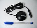
- Mice ( GPS mouse )
- So-called mice are mostly flat-built mobile units consisting of an antenna and receiver, but without a graphical user interface . They continuously supply position data and transfer them, for example, via a serial RS-232 interface or a Bluetooth connection to an external device for further processing.
- Logger
- Loggers continuously determine position data, but save them internally. The track logs can be read out via an interface.
- Navigation devices
- These receivers have a display. The device displays position data on it.
- Navigation systems
- A navigation system shows your location and the route covered on an electronic map. So-called routing calculates the route to a destination.
- Cellular devices
- Mobile radio devices often have a GGNSS receiver. These devices can also work quickly and precisely thanks to additional information received via cellular network (e.g. A-GPS ).
- Precision equipment
- Industrial receivers are equipped with external antennas. The accuracy can be increased significantly through additional information from SBAS systems . Locally available, often commercial DGPS correction signals, for example SAPOS or your own reference receiver , greatly improve location determination. Recalculating the measured values can provide a relative accuracy of less than 1 cm.
- Military equipment (PGPS)
- In addition to the free GPS signal (L1), the GPS satellites transmit another signal (L2). Only the US armed forces and friendly states receive a key to decode the L2 signal.

GPS mouse

GPS data logger
.jpg)

Manufacturer
Well-known manufacturers of GPS devices are Blaupunkt , Garmin , Becker , Leica Geosystems , Lowrance , Magellan Navigation , Mio , Navigon , Silva , TomTom and Trimble .
The receiver modules come from u. a. from manufacturers such as Analog Devices , Conexant , Maxim Integrated Products , SiRF and u-blox .
Card provider
GNSS receivers are often supplemented with electronic maps. Well-known providers of such maps are Tele Atlas and HERE . The national survey offices in Germany and the national topography of Switzerland offer topographic maps. Nautical charts are mainly offered by Navionics, C-Map and Garmin .
There are free and freely available OpenStreetMap maps in several versions for Garmin devices , also for cyclists, hikers, riders and skiers.
Data format
The recipient data is often output in the so-called NMEA format . If the recipient processes the data further, he or she creates a so-called track from the raw data . It is a sequence of track points that are automatically recorded at certain intervals. Almost all proprietary data formats can be converted into the open GPS Exchange Format (GPX).
See also
Individual evidence
- ↑ Garmin Maps on wiki.openstreetmap.org