Great Beerberg
| Great Beerberg | ||
|---|---|---|
|
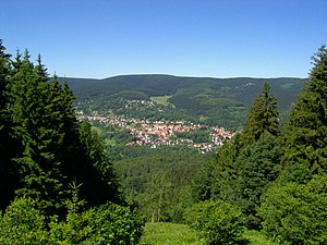
View over Suhl - Goldlauter to the Great Beerberg |
||
| height | 982.9 m above sea level NHN | |
| location | near Heidersbach , Goldlauter and Gehlberg ; City of Suhl , Thuringia ( Germany ) | |
| Mountains | Thuringian Forest | |
| Dominance | 103 km → Ochsenkopf ( Fichtelgebirge ) | |
| Notch height | 389 m ↓ E from Querenbach | |
| Coordinates | 50 ° 39 '34 " N , 10 ° 44' 42" E | |
|
|
||
| Type | Volcanic residue | |
| rock | Quartz porphyry | |
| Age of the rock | Perm | |
| particularities | - highest mountain in Thuringia and the Thuringian Forest - Beerbergmoor |
|

The Great Beerberg is a remnant of a volcano that was active over 250 million years ago and is 982.9 m above sea level. NHN the highest elevation in the Thuringian Forest and Thuringia . It is located between the three Suhler districts of Heidersbach , Goldlauter and Gehlberg and consists of rhyolite ("quartz porphyry").
geography
location
The Great Beerberg rises within its summit region and its southeast flank directly outside the Thuringian Forest Nature Park . Its summit is 3.8 km west-southwest of Gehlberg , on whose boundary it lies, 2.6 km north-northeast of Heidersbach and 3 km north of Goldlauter , all districts of the independent city of Suhl , and 5.5 km east of the city of Zella-Mehlis . Because of its partial location in what was then the Prussian district of Schleusingen , the mountain did not belong entirely to the Free State of Thuringia until 1945 , which may be related to the fact that word of its status as the highest mountain in Thuringia has not yet got around everywhere.
Minor peaks
Between the summit of the Großer Beerberg and that of the neighboring, 978 m high Schneekopf (second highest mountain in Thuringia), there is a saddle which the two peaks tower over by just 60 m. In the western direction, there are various elevations, which by their own name count as mountains, but due to their low dominance and prominence are mostly to be classified as secondary peaks of the Großer Beerberg - with height in meters (m) above sea level:
-
Wildekopf - 943.2 m ; 1.3 km west-northwest
- Sommerbachskopf - approx. 942 m ; 1.3 km northwest
- Lower Beerberg - 890.5 m ; 700 m southwest
- Farmenfleck - 890 m ; 2.8 km northwest
- Spitzer Berg (also: Spitziger Berg ) - 881.5 m ; 3.4 km northwest; already a relatively independent mountain near the federal highway 247 between Oberhof and Zella-Mehlis
Flowing waters
The source of the Schmücker Graben (Langer Bach) , the longest source brook of the Wilder Gera, is located on the transition area from the Großer Beerberg to the eastern side summit of the Teufelskreise . The Goldlauter (Goldene Lauter) , the upper reaches of the Lauter , rises south-east of the mountain on the south-west flank of this secondary peak , and its tributary Dürre Lauter on the south flank of the mountain . On the south and west flanks of the mountain arise two spring streams of Steinfelder water , which feeds the Lauter tributary Mühlwasser , which swells on the northwest flank of its secondary peak Wildekopf . The source of the Lichtenau (Floßgraben, Lübenbach) lies on the north-northwest flank of the mountain .
Protected areas
One of the few preserved rain bogs (high moor) in the Thuringian Forest is located on the summit region of the Großer Beerberg . It is protected as part of the Vessertal-Thuringian Forest Biosphere Reserve and designated as a nature reserve Beerbergmoor (Zone I BR Vessertal-Thuringian Forest ) ( CDDA No. 9357; since 1939; 34.2 hectares ). Entering the highest point of the mountain is not allowed.
Parts of the Thuringian Forest conservation area (CDDA no. 20896; 1963; 1443.43 km² ) are located on the entire mountain . Parts of the fauna-flora-habitat area Schneekopf – Schmücker Graben – Großer Beerberg (FFH no. 5330-301; 11.06 km²) extend up to the summit region and, down to the lower parts of the southern flank, those of the FFH area Thuringian Forest east of Suhl with Vessertal (FFH no. 5330-306; 37.29 km²). Parts of the Middle Thuringian Forest bird sanctuary are located on the mountain (VSG no. 5430-401; 183.72 km²).
Observation tower and platform
Until the end of the 1980s, there was a now demolished observation tower on the mountain. Later, a small platform was built just below the summit at Plänckner's viewpoint , from which there is an excellent view to the south and south-west. The Rennsteig runs past there in the section between Oberhof and Schmücke .

Web links
Individual evidence
- ↑ a b c d Map services of the Federal Agency for Nature Conservation ( information )
- ↑ Dominances and celebrities ( memento of the original from October 19, 2014 in the Internet Archive ) Info: The archive link was inserted automatically and has not yet been checked. Please check the original and archive link according to the instructions and then remove this notice. to highrisepages.de; the notch determined with the help of Elevation Contours in Google Maps is even slightly lower at 585 m , which would result in a notch height of 398 m.
- ↑ cf. also Thüringer Allgemeine from July 1, 2012


