
Snow head
| Snow head | ||
|---|---|---|
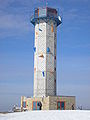
 View of the Schneekopf with the observation and telecommunications tower and the Neue Gehlberger Hütte |
||
| height | 978 m above sea level NHN | |
| location | near Gehlberg ; Independent city of Suhl , Thuringia , Germany | |
| Mountains | Thuringian Forest | |
| Dominance | 1.6 km → Großer Beerberg | |
| Notch height | 59.4 m ↓ eagle | |
| Coordinates | 50 ° 39 '57 " N , 10 ° 45' 52" E | |
|
||
| rock | porphyry | |
| particularities | Schneekopfturm ( AT ), telecommunications tower | |


The Schneekopf near Gehlberg , a district of the Thuringian city of Suhl , is 978 m above sea level. NHN after the neighboring Großer Beerberg ( 983 m ) to the west - the Adler saddle lying in between is only 59.4 m lower than the Schneekopf - the second highest elevation in the Thuringian Forest .
geology
The Schneekopf is of volcanic origin and consists of porphyry . He is known for the snow head balls , porphyry balls ( drusen ) occurring here , which formed crystals ( agates ) inside . They were created during a volcanic eruption in Permian . The Wilde Gera rises on the northern slope of the mountain .
Minor peaks
In addition to the Schneekopf itself, a distinction is made between four secondary peaks. These are:
| Surname | height | location | Dominance | Notch height |
|---|---|---|---|---|
| Vicious circles | 967 m | south, near the jewelry | 0.9 km → Schneekopf | 15.4 m |
| Spruce head | 944 m | south, between Schmücke and Borstenplatz | 0.6 km → vicious circles | 11.6 m ↓ jewelry |
| fire | 885.3 m | east, towards Gehlberg | 0.6 km → Schneekopf | 21.8 m ↓ Golden Bridge |
| Goldlauterberg | 874 m | south, between Borstenplatz and Mordfleck |
The 915.3 m high Sachsenstein is also sometimes viewed as a secondary summit of the Schneekopf, but with a notch height of 37.8 meters it is already an independent summit.
panorama
From the summit plateau there is a good all-round view of other peaks of the Thuringian Forest and the Rhön , across the Thuringian Basin to the Ettersberg near Weimar and the winter sports resort Oberhof . With very good visibility, such as winter inversion weather conditions, the view extends to the Brocken in the Harz Mountains , to the Schneeberg (Fichtelgebirge) and to the western Ore Mountains . The "Wilde Gera" motorway bridge ( A 71 ), the largest arch bridge in Germany with a span of 252 m, is also visible.
History of the mountain
Duke Ernst II of Saxe-Gotha-Altenburg had a small station for astronomical observations built on the summit in 1772, which burned down in 1796. A stone lookout tower was built in 1852, but it has not been preserved. During the Second World War, the Schneekopf had a role in aerial reconnaissance in central Germany. In 1945 it was occupied first by US troops and then by the Red Army . In 1946 a hurricane caused such severe windbreak damage that the summit has been free of trees ever since.
In the second half of the 1950s, a rectangular telecommunications tower was built on the Schneekopf, a type construction, rectangular, green paint, 25 m high, known as the A tower. Its appearance corresponded to the telecommunications tower on the Totenstein near Chemnitz . The SED had started to set up a comprehensive, independent narrowband radio network . From the tower, among other things, radio links were operated to all district leaderships of the SED in the Suhl district as well as to the party's district management and the Suhl district operations management. Due to the lack of a quasi-optical view of the last-named district line, a passive radio relay was installed on the Herleshügel about 800 m away from the Schneekopf . The tower and its surroundings were declared a restricted military area and guarded by armed members of the German People's Police.
In the vicinity of the towers there was an octagonal stone lookout tower from 1852 until it was blown up on August 18, 1970, the lookout tower of which reached the 1000 meter mark. There was also a managed mountain hut until the closure, the Gehlberger Hut, looked after by the Gehlberger Original “Schneiders Ernst”, which also served as a starter house for alpine ski competitions in “Hell”. Below the summit, which was rehabilitated 1996/1997, is the 38.5 ha large nature reserve Schneekopf Moore at the vicious circle .
About one kilometer away from the summit and immediately south of the “vicious circle”, in the Gehlberg area and also on the Rennsteig, is the Schmücke . The well-known Waldgasthof is the starting point for many hikers to visit the Schneekopf summit. For drivers there is a large parking lot on the road in the direction of Oberhof, from there it is about 1.5 km to walk to the summit.
In Gehlberg, four kilometers and 250 meters in altitude from the summit, there is the Schneekopfverein e. V. Its members campaigned for the renaturation of the area after the withdrawal of the Russian armed forces in 1994, advocate a gentle touristic development of their local mountain and keep the memory of the legend of the game accident in the vicious circles alive with their annual Jägerstein Festival on the mountain in mid-September. Since 1999, the Thuringian General has organized the Schneekopf “summit meeting” every year on the first weekend in July with the help of local associations. This is a folk festival directly on the Schneekopf, the beginning of which is an organized star hike to the summit.
In the 1990s there was the idea of raising the mountain to 1000 meters above sea level as part of the renaturation (for example, by excavating the A 71 motorway ). This would have made it the only thousand in Thuringia and the Thuringian Forest would have been added, albeit in an unnatural way, to the series of German low mountain ranges over 1000 meters (see here ). After long discussions, the construction of a new tower began in September 2007, the top of which has been 1004.15 m since its completion in June 2008. The viewing platform can be reached via 126 steps and is then at 1001.1 m. Below the summit is a mountain inn, the Neue Gehlberger Hütte, which opened at the beginning of December 2009 and has also been used for overnight stays since 2010. On June 27, 2018, a Gehlberg company set up a summit cross on the mountain .
Picture gallery

View from the Schneekopf to the Wilde Gera viaduct (A 71)

Telecommunications tower on the Schneekopf in winter - the former district radio control center of the party / SED in Suhl
The observation tower on the Schneekopf

The New Gehlberger Hut

View from the Schneekopf in winter

panorama


literature
- Ludwig Bechstein : Book of legends of the Schneekopf and the Thuringian Henneberger Land . Publication 1837; Verlag Rockstuhl , Bad Langensalza, Reprint 2009, ISBN 978-3-86777-063-7
Web links
- 360 ° panorama camera from the Schneekopf (updated every 10 minutes from shortly before sunrise to shortly after sunset with archive)
- History of the Schneekopf (Neue Gehlberger Hütte)
- Directional radio network of the party (SED) and NVA
Individual evidence
- ↑ a b Map services of the Federal Agency for Nature Conservation ( information )
- ↑ a b Geoproxy Thuringia. Retrieved July 14, 2019 .
- ↑ Lookout tower on the Schneekopf at www.schneekopf.tv
- ↑ Schneekopf turns into a thousand ( memento from January 6, 2010 in the Internet Archive ) . In: Free Word, September 14, 2007
- ↑ Postmark on the mountain of superlatives ( memento of August 22, 2010 in the Internet Archive ) . In Free Word, March 3, 2009
- ↑ Schneekopf in the Ilm district now has a summit cross. Mitteldeutscher Rundfunk , June 27, 2018, accessed on July 19, 2018 .