Adlersberg (Thuringian Forest)
| Adlersberg | ||
|---|---|---|
|
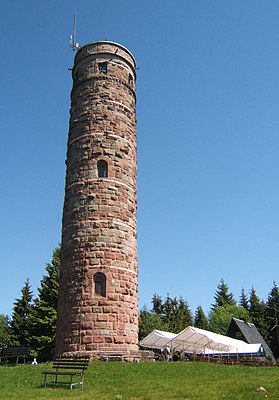
Lookout tower and mountain hut |
||
| height | 849.9 m above sea level NHN | |
| location | near Suhl , Thuringia , Germany | |
| Mountains | Thuringian Forest | |
| Dominance | 0.45 km → Schüßlers Höhe | |
| Notch height | 23.6 m | |
| Coordinates | 50 ° 35 '28 " N , 10 ° 45' 59" E | |
|
|
||
| particularities | Adlersberg Tower ( AT ) | |

The Adlersberg is 849.9 m above sea level. NHN high mountain near Suhl in the Thuringian Forest .
description
At 849.9 m , the Adlersberg is lower than some of its northern neighbors (its "side" peaks Neuhäuser Hügel (890.6 m), Großer Eisenberg (907.4 m), Großer Finsterberg (944.1 m), Schneekopf ( 978 m), Großer Beerberg (982.9 m)), but it towers above all mountains that connect to the south by 200 to 300 m.
If visibility is reasonably clear, the Adlersberg, which is very wide with its immediate secondary peaks, is already visible from a distance of 20 km from the federal motorway 73 near Eisfeld together with the Great Eisenberg, which is separated by a valley.
Location, surroundings and secondary peaks
The Adlersberg lies between Suhl , Schmiedefeld am Rennsteig , Vesser and Hirschbach in the area of the town of Schleusingen , district of Hildburghausen .
The Adlersberg massif with its various (secondary) peaks has the shape of a horseshoe open to the south, within which the alder flowing south rises on the saddle between Großem Erleshügel and Neuhauser Hügel (see below) at a height of almost 780.
To the north, the Adlersberg goes almost directly into the slightly higher Schüßlers Höhe (859 m) and, after an only moderately deep valley, into the Neuhaus hill , which is 891 m higher , to the west of which the Great Erleshügel (839 m) follows south to the Beerberg (809 m) passes, continue finally the Great Dröhberg adjoins the south (about 730 meters) - each with notch depths of meters below the 30th The three last-mentioned mountains are already - like the 746 m high Ringberg with the hotel of the same name, which connects to the Erleshügel as a western pre-peak - (eastern) Suhler Stadtberge.
The Adlersberg massif is bounded to the north by a series of deeper valleys ( Schollengrund, Pfanntal, upper Galgental ), which merge to the north into the valley of the Lauter tributary, Lange Lauter , which flows to Suhl , behind which with the Großer Beerberg (983 m) and the Schneekopf (978 m) are the two highest mountains in Thuringia, while to the northwest the 820 m high saddle between Neuhauser Hügel and Großem Eisenberg forms the border.
The western border is the city of Suhl, the eastern border is the Vesser , while the massif gradually flattens towards the south until the confluence of the Vesser and the Alder in St. Kilian .
Routes to the summit
Representing the many paths from the surrounding villages, here are the two best-known ones : a path that is almost flat except for the last ascent leads from the Wegscheide car park to the Adlersberg, an even shorter but slightly steeper path from the Stutenhaus near Vesser.
Adlersberg Tower
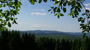
In the years 1884 to 1892 a 22 meter high observation tower was built on the Adlersberg : the Adlersberg Tower . The building material was local porphyry . Extensive repair work took place in 1929 and 1971 to 1972. The tower can usually be climbed daily except Mondays and on Father's Day for a small fee via a spiral staircase made up of 91 steps. The view from the tower extends to the mountains of the Hohe Rhön ( Kreuzberg , Heidelstein , Wasserkuppe ), in front of it lies the Dolmar and even closer to Suhl with the nearby Friedberg industrial area. Following the course of the federal motorway 73 , you can see the Gleichberge . At the foot of the tower a Finnhütte was built in the mid-1970s , called "Bergbaude Adlersberg", where souvenirs were sold and small meals were offered. After the reunification , the building was privatized and operated as a mountain restaurant; the landlord also takes care of the locking service for the tower.
Individual evidence
- ↑ a b Map services of the Federal Agency for Nature Conservation ( information )
- ↑ Eagle Mountain on www.schmiedefeld.de ( Memento from 1 May 2009 at the Internet Archive ), originally accessed 25 November 2011
Web links
- www.panorama-photo.net - View from the observation tower on the Adlersberg


