
Finsterwalde district
| Basic data (as of 1993) | |
|---|---|
| Existing period: | 1952-1993 |
| District : | cottbus |
| Administrative headquarters : | Finsterwalde |
| Area : | 645 km² |
| Residents: | 55,248 (1989) |
| Population density: | 86 inhabitants per km² |
| License plate : | Z (1953–1990) ZF (1974–1990) FI (1991–1993) |
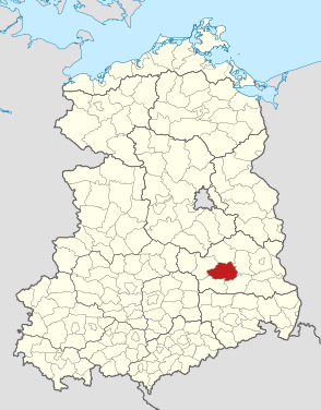
| Location of the district in the GDR | |
  |
|
The Finsterwalde district was a district in the GDR and existed as part of the Cottbus district between 1952 and 1990. It emerged from the Luckau district . From 1990 to 1993 it existed as the Finsterwalde district in the state of Brandenburg . His area is now in the Elbe-Elster district in Brandenburg. The seat of the district administration was in Finsterwalde .
geography
Neighboring areas
The Finsterwalde district bordered clockwise in the north, starting with the Luckau , Calau , Senftenberg , Bad Liebenwerda and Herzberg districts .
history
In the course of the administrative reform of the GDR on July 25, 1952, the Finsterwalde district was rebuilt from parts of the previous Luckau district . This district division remained stable until the end of the GDR. On May 17, 1990, the district was renamed the Finsterwalde district. With the reunification in 1990, the Finsterwalde district became a district under German municipal law . On December 6, 1993, the Finsterwalde district went up in the course of the district reform in Brandenburg with the Herzberg and Bad Liebenwerda districts in the Elbe-Elster district .
politics
Administrative structure
Chairman of the council of the district
- First Deputy Chairman of the Council
- Deputy Chairman of the Council and Chairman of the District Planning Commission
- Deputy Chairman of the Council and Chairman of the Council for Agriculture and Food Production
- Deputy Chairman of the Home Affairs Council
- Deputy Chairman of the Trade and Supply Council
- Secretary to the Council
- Council members
- for finance and prices
- District Construction Director
- for housing policy and the housing industry
- for work
- for local utilities
- for energy
- for traffic and communications
- for environmental protection, water management and recreation
- District School Board
- for culture
- for youth issues, physical culture and sport
- District doctor
Chair of the district council and district administrators (selection)
| Term of office | Surname |
|---|---|
| 1990-1994 | Diethard Haas |
Municipalities of the district
In 1952 the Finsterwalde district had 60 communities and cities. The number will decrease through incorporations and community amalgamations until 1990.
- Arenzhain
- Babben
- beds
- Birkwalde (since October 1, 1973 district of Breitenau)
- Breitenau (October 1, 1973: incorporation of Birkwalde and Möllendorf into Breitenau)
- Brenitz
- Buchhain
- Crinitz
- Dabern (since January 1, 1978 part of Goßmar)
- Doberlug-Kirchhain
- Dollenchen (since May 19, 1974 with the Zürchel district)
- Drößig (since May 19, 1974: district of Eichholz-Drößig)
- Throats
- Eichholz (May 19, 1974: Eichholz and Drößig merged to form Eichholz-Drößig , since then a district of Eichholz-Drößig)
- Finsterwalde (with the district of Nehesdorf (since 1925), January 1, 1988: incorporation of the district of the devastated Bergheide community )
- Fishing water
- Frankena
- Friedersdorf (since October 1, 1973 district of Rückersdorf)
- Gahro
- Göllnitz
- Goßmar (January 1, 1978: incorporation of Dabern and Pießig in Goßmar)
- Groebitz
- Large stretchers (July 1, 1977: merger of large and small stretchers to form stretchers )
- Großkrausnik
- Gruhno
- Hennersdorf
- Small stretchers (July 1, 1977: merger of large and small stretchers to form stretchers)
- Kleinkrausnik
- Lichtena (since May 19, 1974 part of Trebbus)
- Lights field
- Lieskau
- Lindena
- Lindthal (October 1, 1973: incorporation of Rehain in Lindthal)
- Lugau
- Massen (May 19, 1974: incorporation of Tanneberg)
- Möllendorf (district of Breitenau since October 1, 1973)
- Münchhausen (October 1, 1973: incorporation of Ossak in Münchhausen)
- Nexdorf
- Oppelhain
- Ossak (since October 1, 1973 district of Münchhausen)
- Pahlsdorf
- Pießig (since January 1, 1978 part of Goßmar)
- Ponnsdorf
- Prießen
- Rehain (since October 1, 1973 district of Lindthal)
- Rückersdorf (October 1, 1973: incorporation of Friedersdorf near Oppelhain into Rückersdorf)
- Sallgast (since January 1, 1933 with the Klingmühl district )
- Schacksdorf
- Schadewitz
- Schilda
- Schönborn
- Schönewalde
- Sonnewalde
- Sorno
- Staupitz
- Tanneberg (since May 19, 1974: district of Massen)
- Trebbus (May 19, 1974: incorporation of Lichtena into Trebbus)
- Trobitz
- Werenzhain
- Zeckerin
- Zürchel (May 19, 1974: incorporation of Zürchel into Dollenchen)
License Plate
Motor vehicles (with the exception of motorcycles) and trailers were assigned three-letter distinctive signs from around 1974 to the end of 1990, beginning with the pair of letters ZF . The last number plate series used for motorcycles was ZT 50-01 to ZT 99-99 .
At the beginning of 1991 the district received the distinctive sign FI . It was issued until the end of 1993. It has been available in the Elbe-Elster district since April 2, 2013 ( license plate liberalization ).
Web links
- Ponnsdorf in the RBB program Landschleicher on November 9, 2008
Individual evidence
- ↑ a b Federal Statistical Office (ed.): Municipalities 1994 and their changes since 01.01.1948 in the new federal states . Metzler-Poeschel, Stuttgart 1995, ISBN 3-8246-0321-7 .
- ↑ Law on the self-administration of municipalities and districts in the GDR (municipal constitution) of May 17, 1990
- ↑ An overview of the administrative and archive history of the Brandenburg districts since 1815. From Wolfgang Blöß
- ↑ State Office for Data Processing and Statistics State of Brandenburg Historical community directory of the State of Brandenburg 1875 to 2005 19.4 District Elbe-Elster PDF
- ↑ Andreas Herzfeld: The history of the German license plate . 4th edition. German Flag Society V., Berlin 2010, ISBN 978-3-935131-11-7 , pp. 303 .
- ↑ Andreas Herzfeld: The history of the German license plate . 4th edition. German Flag Society V., Berlin 2010, ISBN 978-3-935131-11-7 , pp. 494 .