Zeckerin
|
Zeckerin
City of Sonnewalde
Coordinates: 51 ° 42 ′ 42 " N , 13 ° 37 ′ 56" E
|
||
|---|---|---|
| Incorporation : | May 1, 2002 | |
| Postal code : | 03249 | |
| Area code : | 035323 | |
|
Location of Zeckerin in Brandenburg |
||
|
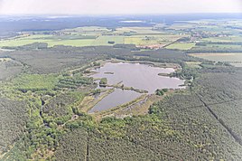
in the foreground the Lugkteich, in the background the Sonnewald district of Zeckerin (June 2013)
|
||
Zeckerin ( Lower Sorbian Zagorin ) is a district of the town of Sonnewalde in the Elbe-Elster district in Brandenburg .
Geography and transport links
Zeckerin located north of the city core Sonnenwalde at the county road K 6234. East extends the B 96 , southern the country road L 701 and southwest the L extends around the west 703. 328 ha large protected area Lugkteichgebiet with the Lugkteich . Not far to the north is the border with the Dahme-Spreewald district .
history
Zeckerin was incorporated into Sonnewalde on May 1st, 2002.
Attractions
- In the list of architectural monuments in Sonnewalde , the village church , a half-timbered church , is listed as the only architectural monument for Zeckerin .
- In the list of natural monuments in the Elbe-Elster district , a pedunculate oak is listed as a natural monument for Zeckerin .
Web links
Commons : Zeckerin - Collection of images, videos and audio files

