Tanneberg (Massen-Niederlausitz)
|
Tanneberg
Municipality mass Niederlausitz
Coordinates: 51 ° 39 ′ 52 ″ N , 13 ° 44 ′ 3 ″ E
|
|
|---|---|
| Height : | 105 m above sea level NHN |
| Incorporation : | May 19, 1974 |
| Incorporated into: | Crowds |
| Postal code : | 03238 |
| Area code : | 03531 |
|
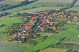
Aerial view
|
|
Tanneberg is a residential area in Massen , a district of the official community of Massen-Niederlausitz in the Elbe-Elster district in Brandenburg . The place belongs to the Amt Kleine Elster (Niederlausitz) .
location
Tanneberg is located in Niederlausitz , about four kilometers as the crow flies northeast of the town of Finsterwalde . Surrounding villages are the district of Breitenau in the north, which belongs to the city of Sonnewalde , Babben in the northeast, Lindthal in the east, Massen in the south, Gröbitz in the west and Möllendorf in the northwest, which in turn belongs to Sonnewalde .
Tanneberg is on the district road 6228, which leads from Sonnewalde to Massen. County road 6229 runs west of the village. Tanneberg is located on the Kleine Elster . The Tanneberger Sumpf-Gröbitzer Busch nature reserve is located southwest of the village .
history
The street village of Tanneberg was first mentioned in 1424 with the name "Tannenberg", the place name means "village on a mountain overgrown with fir trees". For 1538 the place is recorded with the name Tannebergk.
Before the Congress of Vienna and the cession of territory from the Kingdom of Saxony to the Kingdom of Prussia, Tanneberg belonged to Saxony. From 1816 the place belonged to the district of Luckau in the Prussian province of Brandenburg . In 1824 there were 29 houses with 185 inhabitants in Tanneberg, the village also had a water mill (today's Buschmühle residential area ) and two windmills . The village was historically characterized by agriculture, 26 farms were run by farmers . There were also three meetinghouses. Tanneberg was a member of the Dobrilugk Rent Office and belonged to the masses of the church. In 1840, according to the topographical-statistical overview of the administrative district of Frankfurt adO, Tanneberg had 42 residential buildings with 219 inhabitants. By 1864, the number of inhabitants in Tanneberg rose to 261, at that time the place was part of the Finsterwalde office in the Dobrilugk registry.
Tanneberg belonged to the Luckau District until 1815 , which was converted into the Luckau district after the changes in area at the Congress of Vienna. After the Second World War , the community was initially in the Soviet occupation zone and then in the GDR . During the district reform carried out in the GDR on July 25, 1952, Tanneberg was incorporated into the Finsterwalde district in the Cottbus district. On May 19, 1974 it was incorporated into the neighboring community of Massen. After the reunification , the Finsterwalde district was renamed the Finsterwalde district and finally dissolved, the municipality of Massen with the Tanneberg district was assigned to the Elbe-Elster district and joined the Kleine Elster (Niederlausitz) office . On December 31, 1997, the community of Massen merged with three other communities to form the new community of Massen-Niederlausitz . Since then, Tanneberg has been a residential area of this community.
Population development
| Population development in Tanneberg from 1875 to 1971 | |||||||||||||
|---|---|---|---|---|---|---|---|---|---|---|---|---|---|
| year | Residents | year | Residents | year | Residents | year | Residents | year | Residents | ||||
| 1875 | 297 | 1910 | 249 | 1933 | 247 | 1946 | 348 | 1964 | 270 | ||||
| 1890 | 252 | 1925 | 249 | 1939 | 250 | 1950 | 325 | 1971 | 281 | ||||
Web links
Individual evidence
- ↑ Reinhard E. Fischer : The place names of the states of Brandenburg and Berlin: age - origin - meaning . be.bra Wissenschaft, 2005, p. 167 .
- ↑ Ernst Eichler : The place names of Niederlausitz. 1st edition. VEB Domowina publishing house, Bautzen 1975, p. 111.
- ↑ August Schumann: Complete state, postal and newspaper encyclopedia of Saxony, Vol. 11. Schweitz to Trebishayn. Gebr. Schumann, Zwickau 1824 Online at Google Books , pp. 574-575
- ↑ Topographical-statistical overview of the government district of Frankfurt ad O. Gustav Harnecker's bookstore, Frankfurt a. O. 1844 Online at Google Books , p. 163.
- ↑ Topographical-statistical manual of the government district of Frankfurt a. O. Verlag von Gustav Harnecker u. Co., 1867 Online at Google Books , p. 187.
- ^ Historical register of the state of Brandenburg from 1875 to 2005. (PDF; 331 KB) Elbe-Elster district. State Office for Data Processing and Statistics State of Brandenburg, December 2006, accessed on August 26, 2018 .
