
Lower Lusatia


The Lower Lusatia ( Lower Sorbian Dolna Łužyca , Upper Sorbian Delnja Łužica , Polish Dolne Łużyce ) is a region and a former territory in the south of Brandenburg , in northern Saxony and in western Poland . Its center is the city of Cottbus .
It is the northern part of the Lausitz . The West Slavic people of the Sorbs are at home in Lower Lusatia, as in Upper Lusatia , which borders on the south .
coat of arms
Since 1363, Niederlausitz has had its own coat of arms with a bull in silver, sometimes standing, sometimes walking. After the death of Emperor Charles IV in 1387, the bull was depicted in red with a tail crossed over the back in silver. It is thus similar to the coat of arms of the city of Luckau , which was one of the seven important cities of Niederlausitz in the Middle Ages. In contrast to the Luckau bull, the "reinforcement" (horns and claws) of the Lower Lusatian bull is not gold-tinged. It is still valid today.
history
The former margraviate "Mark Lausitz", which emerged during the eastern expansion of the Holy Roman Empire , has been known as "Niederlausitz" since around the 14th century.
Geography and nature

location
The territory of Niederlausitz is limited by the rivers Spree in the north, Bober in the east, Schwarze Elster in the south and Dahme in the west.
The northern border of Niederlausitz runs north from Golßen to Hartmannsdorf, follows the Spreebogen or the Spree via Schlepzig , Pretschen to the north of Zaue to Schwielochsee . From there it goes north of Friedland and Mixdorf in the Ziltendorfer lowlands on the Oder and finally eastwards to Niemaschkleba (Polish: Chlebowo ), part of the rural community of Gubin , in Poland. In Poland, the eastern border runs roughly along the Niemaschkleba – Sommerfeld line. The place Sommerfeld (Polish: Lubsko ) itself does not belong to Niederlausitz. It then follows the Bober from Legel (Polish Lagoda) to Christianstadt (Polish Krzystkowice ) and turns west of the Bober to Kunzendorf (Polish Kunice Żarskie), a south-eastern district of Sorau (Polish Żary ).
In the southeast the line from Kunzendorf to Groß Särchen (Polish: Żarki Wielkie ) on the Lausitzer Neisse forms the border and follows from there along the former Brandenburg-Saxon border until 1952 to the Schwarzen Elster, then to Lauchhammer (formerly Mückenberg). In the south-west, the border for Niederlausitz as an administrative area (including margraviate) changed several times. Finsterwalde, Senftenberg, Doberlug-Kirchhain and Sonnewalde belonged to Saxon territory in different epochs, the border between the Dobrilugk dominion, now Doberlug-Kirchhain and the Brehna county can be seen as the most stable. The Elbe-Elster district has existed since 1993 , derived from the Elbe-Elster-Land , with which you can see the western border either of the old Buchhain line via Trebbus and Luckau to Schenkendorf (west of Golßen ) or along the Oberspreewald-Lausitz district .
geology

The German part of Niederlausitz belongs to the north German lowlands . The Lausitz border wall runs through it , part of the southern ridge that continues northwest in the Lower Fläming . It is the main terminal moraine of the Warthestadium of the Saale Ice Age . The highest elevation of the Lusatian border wall and thus the Lower Lusatia is the 227 m high ridge mountain ( Góra Żarska in Polish ) near Żary . The southern land ridge represents a watershed here . Small rivers such as the Kleine Elster and streams, which mostly flow northwards and flow into the Spree in the Spreewald, arise along a broad parallel line through Finsterwalde to Calau ( Calau Switzerland ) . The Dahme , Spree and Neisse rivers coming from the south created breakthroughs . South of the Lusatian border wall is the glacial valley of the Black Elster .
In the time of the early Vistula high glacial , only the northern Lower Lusatia was glaciated during the Brandenburg stage (approx. 19,600 to 19,000 years ago). The remnants of the heavily weathered and partially completely eroded terminal moraine of this stage and the associated sand areas are located north of the Spreewald. The Glogau-Baruther Urstromtal belongs to this younger glacial series as a drainage channel , whose bed in Niederlausitz is used by the Malxe and the Spree , which branches off into the Spreewald here .
The surface of the Lower Lusatia was fundamentally created in the late Middle Pleistocene around 150,000 years ago and formed in the following epochs of the New Pleistocene and the Holocene in a glacial, but above all periglacial way through weathering, erosion, washing out and drifting as well as through aeolian and fluvial sedimentation .
In addition to lignite and gravel, there are also deep-lying deposits of copper, which extend from Spremberg and Weißwasser to Lubin in Poland .
The last far-reaching changes in the landscape began in the 1930s, and this was increasingly the case during the GDR era when large open- cast lignite mines were built , to which over 100 villages fell victim . Places are being destroyed up to the present day, such as Horno , Lakoma or Kausche .
Waters and landscapes


→ See also: Lausitzer Seenland
Rivers
Landscapes and natural spaces
- Lusatian border wall
- Niederlausitzer Heidelandschaft nature park , partly in today's Elbe-Elster-Land
- Niederlausitzer Landrücke Nature Park
- Schlaubetal Nature Park
- Spreewald
- Mehßower landscape
climate

Niederlausitz is one of the regions with the lowest rainfall in Germany. In just three to four months per year, a monthly rainfall of more than 50 mm is achieved.
Urban development


Urban centers were and are Cottbus (Chóśebuz) as the largest city, the historical capitals of the state Lübben / Spreewald (Lubin) and Luckau (Łukow) as well as Guben (Gubin), Calau (Kalawa), Finsterwalde (Grabin), Forst (Baršć), Senftenberg (Zły Komorow) Spremberg (Grodk), Lübbenau / Spreewald (Lubnjow) Vetschau (Wětošow) and southwest Doberlug-Kirchhain (formerly Dobrilugk) and Lauchhammer (Luchow; Upper Sorbian : Železarnje), see also the Elbe-Elster-land , and in the Polish part of the city of Żary (Žarow; German : Sorau).
Currently, the Lower Lusatia area is divided into several districts within the state of Brandenburg.
Counties and urban districts
- Cottbus (independent city) (CB)
- Elbe-Elster district (EE), partially
- District of Dahme-Spreewald (LDS), partially
- District Oberspreewald-Lausitz (OSL)
- Oder-Spree district (LOS), partially
- District of Spree-Neisse (SPN)
Regardless of the relatively sparse settlement, Niederlausitz, like all regions of Central Europe, is a cultural landscape that has been intensively designed by the people. It is characterized by pine forests , heaths and alluvial forest- like alder forests , but also by agricultural areas, grasslands and fields .
economy
Industry

After the reunification of Germany in 1990, the German part of Niederlausitz was largely de-industrialized in the first few years. There are only small remnants of the formerly important glass industry , textile industry and wood processing . Due to the lack of capital and the much more efficient technology, especially in the main branch of energy generation, a large number of employees have left Niederlausitz again. The lignite is three lignite power plants are still the largest employer, the export of electrical energy into the German power grid main industry. Renewable energies alone are intended to cover the electricity demand in some regions. Accordingly, there are also small and medium-sized companies in metal processing and mechanical engineering in the region. Research and development is carried out in the biotechnology (Lausitz University of Applied Sciences) and chemical industry (BASF). In addition, several of the largest solar parks such as the Finsterwalde solar park and the Lieberose solar park have been in operation since the mid-2000s .
A problem in the development of renewable energy sources to check out the line capacity and the sluggish expansion of the pipeline network in the south of Germany. During the economic redefinition initially also projects failed as the production of airships ( Cargo Lifter ), but were by other today as the holiday park Tropical Islands compensated.
Around Spremberg and Weißwasser, around 200 million tons of copper ore are to be mined from a depth of 1500 m from around 2015.
In the Lusatian Lakeland, tourism has been established as a new branch of the economy since the 2000s and is growing in importance.
wage
After 22 years in reunified Germany, there is also a shortage of skilled workers in Niederlausitz, which is due, among other things, to the aging population, but also lower wages at a similar price level compared to other regions in Germany. On February 21, 2012, the fuel price for super gasoline (E5) of 1.669 € was roughly the same as the daily average for the whole of Germany (1.675 €).
Infrastructure

Due to the transport of the lignite, the railway network is very well developed, every city with more than 8,000 inhabitants offers connections to the surrounding cities of Berlin, Cottbus, Dresden and Leipzig. Since the late 1980s, all of the routes operated, with the exception of the Cottbus – Görlitz main line, have been double-tracked and electrified. The connection to the Polish network is only possible on single-track lines. The exception is the route via Hoyerswerda and Kohlfurth (Węgliniec) to Breslau (Wrocław).
Rail connections
- Berlin – Zossen – Luckau / Uckro – Doberlug – Kirchhain – Elsterwerda – Großenhain – Dresden
- Berlin – Lübben (Spreewald) –Lübbenau / Spreewald – Cottbus – Spremberg – Weißwasser – Görlitz
- Cottbus – Forst (Lausitz)
- Cottbus – Guben and Guben – Frankfurt (Oder)
- Leipzig / Halle-Torgau-Falkenberg / Elster-Doberlug-Kirchhain-Finsterwalde-Calau-Cottbus
- Kamenz (Upper Lusatia) –Senftenberg – Calau – Lübbenau
- Węgliniec in Poland – Hoyerswerda – Ruhland – Senftenberg – Lauchhammer – Elsterwerda – Bad Liebenwerda – Falkenberg / Elster Lower Silesian Freight Highway
- Dresden – Großenhain – Senftenberg – Cottbus
Streets
The road network is made up of the federal highways 87 , 96 , 97 , 102 , 112 , 115 , 156 , 169 , 179 and 320 , with plans to expand the B 169 according to the 2 + 1 system . In order to achieve better connections to the north and west, the 2 + 1 expansion of the B 87 from Leipzig to Frankfurt (Oder) is required. Motorways 13 and 15 run in north-south-east directions .
Education and health
The educational and supply facilities are well developed with the Brandenburg Technical University of Cottbus , the Lausitz University of Applied Sciences and, for example, the Carl-Thiem-Klinikum Cottbus and the Klinikum Niederlausitz , whereby the increasing shortage of general practitioners is a major problem.
Agriculture
The agriculture on relatively poor soil in Germany niederschlagsärmstem air is limited productive. Mainly flax for linseed oil , corn , rapeseed and asparagus are grown around Calau. Some agricultural products from Niederlausitz, especially from the Spreewald, have a very good reputation throughout Germany.
tourism
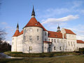
Fürstlich Drehna Castle between Crinitz and Luckau
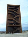
The Rostiger Nagel observation tower on the Sorno Canal made of COR-TEN steel

Geierswalder See
IBA terraces


The Spreewald is traditionally of touristic importance . The city of Cottbus as well as the parks of Prince Pückler , the Branitzer Park in (Cottbus-) Branitz and the Fürst-Pückler-Park Bad Muskau , which are important from a garden architecture point of view, are also significant . Due to the renaturation and flooding of the former opencast mines , the Lusatian Lake District tourist region is also emerging.
The Niederlausitz is developed by long-distance and regional cycle paths. The Oder-Neisse cycle path borders the region in the east. It is crossed centrally by the Spreeradweg . The Froschradweg and the Niederlausitzer Bergbautour (cross-border Brandenburg and Saxony ) are ideal regional routes . In the north in the Spreewald area, the Gurken Cycle Path and the Fürst-Pückler Tour follow. In the southwest, the Elster cycle path leads to the Elbe cycle path .
Culture
In terms of entertainment, there are several theaters and ensembles in Cottbus, such as the Cottbus State Theater with the Cottbus Philharmonic Orchestra, the New Stage in Senftenberg, and the more than 100-year-old functional cinema buildings, two of the oldest, the Weltspiegel Cottbus and Weltspiegel Finsterwalde.
Regarding the Niederlausitzer customs and rituals are particularly enshrined in the Lausitz Sorbian to mention traditions, such as the Zampern (camprowanje) , rooster plucking (kokot) , how to decorate Easter eggs or bird wedding . The Sorbian costumes also represent a part of the folk culture - in particular the Spreewald costumes - which today are almost only worn on festive days and for tourist purposes.
language

In Lower Lusatia, the Lower Lusatian dialect of German is mainly spoken today, and Lower Sorbian (also known as Wendish ) is spoken by around 7-10,000 people . In the 18th century, the entire area of Lower Lusatia, with the exception of the German cities, was monolingual Sorbian. In most places, the rural population hardly spoke any German. This still applied to the central part of Niederlausitz until the second half of the 19th century, whereas in the periphery, v. a. in the areas east of Neisse and Oder, in the Luckau district and in the area around Doberlug-Kirchhain, the language change to German had already taken place due to an active Germanization policy in schools and churches. According to statistics from Arnošt Muka from the 1880s, 59.3% of the inhabitants of the Cottbus district spoke Lower Sorbian at that time; in the Spremberg district it was 42.1% and in the Calau district about 20%. In his detailed reports from the towns, especially in the Cottbus district, Muka explicitly pointed out that in many villages there are hardly any residents who speak German.
In the course of the 20th century, Lower Sorbian came to an end due to the increased Germanization efforts on the part of the state in the first five decades, due to the massive influx of workers v. a. in the lignite industry and on the other hand by German-speaking resettlers from the former eastern areas after 1945 as well as through other assimilation factors also in the central Lower Lusatian districts finally in the role of the minority language. In 1956 it was the language of the majority in 24 communities in the Cottbus district, but the proportion of the district's total population had shrunk to 29%. In many villages the language change took place within only two to three generations. Today the Lower Sorbian language is a minority language in all places and is mostly still in use in the communities north of Cottbus ( Dissen-Striesow , Schmogrow-Fehrow , Teichland , Turnow-Preilack etc.).
See also:
See also
literature
- Settlement of Lausitz in early history and in the Middle Ages
- Günter Wetzel : Germans - Slavs - Germans in Lower Lusatia. In: Report of the Roman-Germanic Commission . Volume 83, 2002, pp. 206-242.
- travel Guide
- Anja Pohontsch, Mirko Pohontsch, Rafael Ledschbor, Guido Erbrich: Where the Wendenkönig has hidden his treasures - on the move in the Sorbian Lower Lusatia. Domowina-Verlag, Bautzen 2011, ISBN 978-3-7420-1985-1 .
- Recent history
- Günter Bayerl : Periphery as fate and opportunity - studies on the recent history of Niederlausitz. (Lower Lusatia at the beginning of the 21st century - past and present, vol. 1). Waxmann, Münster / New York / Munich / Berlin 2011, ISBN 978-3-8309-2365-7 . (online at: books.google.de )
- Rudolf Lehmann : History of Niederlausitz. de Gruyter, Berlin 1963, DNB 452752043 .
- Culture
- Anne Gehrmann, Dirk Schumann (ed.): Village churches in Niederlausitz. History - architecture - monument preservation. Lucas-Verlag, Berlin 2011, ISBN 978-3-86732-054-2 .
- Encyclopedic Articles
- Lausitz , encyclopedia entry, in: Meyers Großes Konversations-Lexikon . 6th edition, Volume 12, Leipzig / Vienna 1908, pp. 254-257 ( Zeno.org ).
Web links
- Information about Niederlausitz
- German-Sorbian place name dictionary of Niederlausitz
- Archive of disappeared places
- interesting and worth seeing points in Niederlausitz
Individual evidence
- ↑ Simone Wendler : Wind power in Elbe-Elster does not get into the grid. In: Lausitzer Rundschau . Lausitzer VerlagsService GmbH, February 23, 2012, accessed on January 7, 2014 .
- ↑ The treasure of Spremberg. on: time online. April 15, 2010.
- ↑ Copper ore deposits in the Saxon-Brandenburg Lausitz. ( Memento of the original from September 26, 2011 in the Internet Archive ) Info: The archive link was inserted automatically and has not yet been checked. Please check the original and archive link according to the instructions and then remove this notice. on: sachsen.de
- ↑ The lunar landscape of Lausitz should bloom again. on: The world. online, July 21, 2010.
- ↑ Low wages drive out skilled workers in the OSL district. In: Lausitzer Rundschau. March 2, 2012.
- ↑ The increasing need for skilled workers in the electrical industry offers numerous opportunities for those looking for work and training. Press release from the city administration of Cottbus.
- ↑ Fuel prices remain at record levels. on: greenpeace-magazin.de , accessed on April 30, 2012.
- ↑ New record prices at Lausitz fuel pumps. In: Lausitzer Rundschau. February 21, 2012, accessed April 30, 2012.
- ↑ Three years of congestion stress: B 169 will be expanded from 2013. In: Lausitzer Rundschau. August 18, 2009.
- ↑ After the stop for the four-lane B 87: Regional companies are calling for expansion in the planned form. In: Leipziger Internet Zeitung March 3, 2011.
- ↑ Ernst Tschernik: The development of the Sorbian population. Akademie-Verlag, Berlin 1954, p. 138
- ↑ Information from Ernst Tschernik's Sorbian statistics in: Ludwig Elle: Sprachpolitik in der Lausitz. Domowina-Verlag, Bautzen 1995, p. 259
- ↑ For Horno on the eastern edge of the Lower Sorbian language area, Arnošt Muka stated in 1884 that almost all residents speak Sorbian, but many do not speak German. Only 70 years later, Ernst Tschernik still has 71 of 674 inhabitants with active Sorbian language skills, including only four children and young people.
Coordinates: 51 ° 45 ′ 0 ″ N , 14 ° 30 ′ 0 ″ E