
Fürst-Pückler-Weg
| Fürst-Pückler-Weg | |
|---|---|

|
|
| overall length | approx. 500 km |
| location |
|
| Starting point |
Luckau 51 ° 51 ′ 10 ″ N , 13 ° 42 ′ 57 ″ E |
| Target point |
Luckau 51 ° 51 ′ 10 ″ N , 13 ° 42 ′ 57 ″ E |
| Flooring | 75% paved |
| Height difference | Total ascent: 2047 m, total gradient 1994 m |
| Traffic volume | mostly low |
| Connection to |
Gurken-Radweg , Niederlausitzer Bergbautour , Oder-Neisse-Radweg , Schwarze-Elster-Radweg , Seenlandroute , Spreeradweg , Tour Brandenburg |
| ADFC certification | 4 out of 5 stars |
| Website URL | fuerst-pueckler-radweg.de |

Fürst-Pückler-Weg is the name for a cycle path in the south of Brandenburg and, on short sections, in the north of Saxony . It was officially opened in 2005. The 500 km long cycle path has been included in the project list of the International Building Exhibition Fürst-Pückler-Land under the motto 500 kilometers through time . In 2006, the cycle path was the first long-distance cycle path in Germany to be certified with a seal of approval according to the criteria of the ADFC .
course
The long-distance cycle path touches the following places in an anti-clockwise direction:
Luckau - Altdöbern - Großräschen - Finsterwalde - Doberlug-Kirchhain - Bad Liebenwerda - Elsterwerda - Plessa - Lauchhammer - Senftenberg - Großkoschen - Spremberg - Forst (Lausitz) - Cottbus - Werben (Spreewald) - Burg (Spreewald) - Raddusch - Calau
Route sign
The Fürst-Pückler-Weg is continuously marked with a symbol, which consists of a blue square on top and a stylized small white Fürst-Pückler pyramid .
Attractions
The long-distance cycle path leads past traditional settlements and villages, castles and parks in Lusatia, which is characterized by lignite mining; affects, among other things, almost all IBA projects in the Brandenburg and Saxon parts:
Branitzer Park - Forster Rosengarten - Glashütte Döbern - Fürst-Pückler-Park Bad Muskau - Kromlauer Park - Muskau fold arch - viewpoint open pit Welzow - Lusatian Lakeland with floating houses - Garden City Marga - Artistic Casting Museum Lauchhammer - Biotowers Lauchhammerda - Power Plant Plessa - Post windmill and miniature windmills - Briquette factory Louise - visitor mine overburden conveyor bridge F60 - IBA terraces - art barn Pritzen - palace and park Fürstlich Drehna - Heinz Sielmann nature park center Wanninchen - Slavic castle Raddusch - Peitz with fishing museum and iron and steel works.
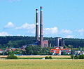
Plessa adventure power plant
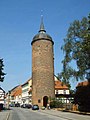
Red Tower Luckau

Princely Drehna Castle

Water pyramid in the Branitzer Park in Cottbus


Literature and maps
- Tour book: Experience the landscape Experience the landscape - cycling on the Fürst-Pückler-Weg with a map (scale: 1: 100,000), International Building Exhibition Fürst-Pückler-Land, ISBN 3-9809844-0-0
- Cycling and leisure map of South Brandenburg
- IBA mid-term documentation , ISBN 3-9809844-1-9
- Fürst-Pückler-Weg . Verlag Esterbauer GmbH, A-Rodingersdorf, 2009, ISBN 978-3-85000-258-5
Web links
- The Fürst-Pückler-Weg on the IBA Fürst-Pückler-Land homepage , accessed on October 29, 2017.
- The Fürst-Pückler-Weg at www.reiseland-brandenburg.de , accessed on October 29, 2017.
- Fürst-Pückler-Weg at www.niederlausitz.de , accessed on October 29, 2017.
- Fürst-Pückler-Weg in the ADFC tour portal ( Memento from March 4, 2016 in the Internet Archive )
Individual evidence
- ↑ a b Fürst-Pückler-Weg ( Memento from March 4, 2016 in the Internet Archive ), at www.adfc-tourenportal.de, accessed on October 29, 2017
- ↑ 500 kilometers through time , on iba-see2010.de, accessed on October 29, 2017