
Schwarze-Elster cycle path
| Schwarze-Elster cycle path | |||||||||||||||||||||||||||||||||||||||||||||||||||||||||||||||||||||||||||||||||||||||||||||||||||||||||
|---|---|---|---|---|---|---|---|---|---|---|---|---|---|---|---|---|---|---|---|---|---|---|---|---|---|---|---|---|---|---|---|---|---|---|---|---|---|---|---|---|---|---|---|---|---|---|---|---|---|---|---|---|---|---|---|---|---|---|---|---|---|---|---|---|---|---|---|---|---|---|---|---|---|---|---|---|---|---|---|---|---|---|---|---|---|---|---|---|---|---|---|---|---|---|---|---|---|---|---|---|---|---|---|---|---|
| overall length | 190 km | ||||||||||||||||||||||||||||||||||||||||||||||||||||||||||||||||||||||||||||||||||||||||||||||||||||||||
| location |
|
||||||||||||||||||||||||||||||||||||||||||||||||||||||||||||||||||||||||||||||||||||||||||||||||||||||||
| Flooring | mostly paved | ||||||||||||||||||||||||||||||||||||||||||||||||||||||||||||||||||||||||||||||||||||||||||||||||||||||||
| Traffic volume | little | ||||||||||||||||||||||||||||||||||||||||||||||||||||||||||||||||||||||||||||||||||||||||||||||||||||||||
| Connection to |
Schradeln , Elsterradtour , historical city center cycle routes 5 , historical city center cycle routes 6 |
||||||||||||||||||||||||||||||||||||||||||||||||||||||||||||||||||||||||||||||||||||||||||||||||||||||||
|
Route
|
|||||||||||||||||||||||||||||||||||||||||||||||||||||||||||||||||||||||||||||||||||||||||||||||||||||||||


The Schwarze-Elster-Radweg is a 190-kilometer long -distance cycle path in the south of Brandenburg and north of Saxony, as well as short sections in the east of Saxony-Anhalt . The cycle path runs from the source of the Black Elster at 317 m above sea level. NHN to its confluence with the Elbe at 69 m above sea level. NHN through the foothills of the Lusatian mountains near Kamenz and later mostly directly on the dike of the Black Elster . It is marked with a picture of a magpie .
course
The long-distance cycle path affects the following places, among others:
Elstra - Kamenz - Milstrich - Wittichenau - Hoyerswerda - Großkoschen - Senftenberg - Ruhland - Lauchhammer - Plessa - Kahla - Elsterwerda - Saathain - Würdenhain - Haida - Zeischa - Bad Liebenwerda - Wahrenbrück - Falkenberg / Elster - Uebigau - Munich - Herzberg (Elster) - Jessen (Elster) - Elster (Elbe)
Attractions
The long-distance cycle path leads past traditional settlements and villages, castles and parks in Lusatia, which is characterized by lignite mining :
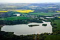
Lausitzer Bergland - Lausitzer Seenland - Senftenberger See - Garden City Marga - Artistic Casting Museum Lauchhammer - Bio Towers Lauchhammer - Elster Mill Plessa - Power Plant Plessa - Post windmill and Miniature Park Elsterwerda - Lubwart Tower Bad Liebenwerda - Little Spreewald in Wahrenbrück
At the eastern entrance to Jessen , a vineyard with a historic wine press can be visited, and a historic wine press is also set up in Schweinitz .
photos
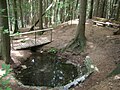
Source of the Black Elster at Kindisch

View of downtown Kamenz
View of the large pond of Deutschbaselitz

Krabat column in Wittichenau
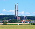
Plessa adventure power plant

Market and church in Jessen (Elster)


Literature and maps
- Niederlausitzer Heidelandschaft nature park, spa town Bad Liebenwerda, Mühlberg, Schradenland , Sachsen-Kartographie, ISBN 3-932281-63-2
- District town of Herzberg, Schliebener Land and the surrounding area , 1: 50,000, Saxony cartography, ISBN 3-932281-61-6
- Bicycle tours in the Elbe-Elster-Land , 1: 50,000, Saxony-Kartographie, ISBN 3-932281-84-5
- Adventure map Elbe-Elster-Land with cycle path network , Saxony cartography
- Cycling and leisure map of South Brandenburg
- ADFC regional map of Dresden and the surrounding area , ADFC , ISBN 978-3-87073-643-9
Web links
- The Schwarze-Elster-Radweg on www.reiseland-brandenburg.de
- The Schwarze-Elster-Radweg on www.regionalverein-jessen.de
- Schwarze-Elster-Radweg on www.schoene-radwege.de
Individual evidence
- ↑ a b Schwarze-Elster-Radweg , on reiseland-brandenburg.de, accessed on May 23, 2019