Mixdorf
| coat of arms | Germany map | |
|---|---|---|

|
Coordinates: 52 ° 12 ' N , 14 ° 24' E |
|
| Basic data | ||
| State : | Brandenburg | |
| County : | Oder-Spree | |
| Office : | Schlaubetal | |
| Height : | 61 m above sea level NHN | |
| Area : | 13.22 km 2 | |
| Residents: | 902 (Dec. 31, 2019) | |
| Population density : | 68 inhabitants per km 2 | |
| Postal code : | 15299 | |
| Area code : | 033655 | |
| License plate : | LOS, BSK, EH, FW | |
| Community key : | 12 0 67 324 | |
| Office administration address: | Bahnhofstrasse 40 15296 Müllrose |
|
| Mayor : | Dieter-Lothar Mutke | |
| Location of the community Mixdorf in the Oder-Spree district | ||
Mixdorf ( Mikošojce in Lower Sorbian ) is a municipality in the Oder-Spree district in Brandenburg . It belongs to the office of Schlaubetal based in the city of Müllrose .
Community structure
The residential area Kupferhammer belongs to the municipality of Mixdorf .
history
Mixdorf has belonged to the Lübben (Spreewald) district in the province of Brandenburg since 1836 and to the Eisenhüttenstadt-Land district in the GDR district of Frankfurt (Oder) from 1952 . The community has been in the Oder-Spree district in Brandenburg since 1993.
Population development
|
|
|
|
|
Territory of the respective year, number of inhabitants: as of December 31 (from 1991), from 2011 based on the 2011 census
politics
Community representation
The community council of Mixdorf consists of 10 community representatives and the honorary mayor with the following distribution of seats:
| Voter group | Seats |
|---|---|
| Common mix village | 6th |
| Community of voters against wind power in Mixdorf | 4th |
mayor
- 1998–2014: Karl-Friedrich Rubach
- 2014–2109: Marlies Janisch
- since 2019: Dieter-Lothar Mutke
Mutke was elected in the mayoral election on May 26, 2019 with 79.2% of the valid votes for a term of five years.
coat of arms
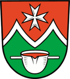
The coat of arms was approved on December 18, 2012.
Blazon : “Divided by red and green by a curved silver double rafter; above an eight-pointed silver (Johanniter) cross, below a red filled silver crucible with two handles. "
The coat of arms was designed by the heraldist Uwe Reipert.
Attractions
The list of architectural monuments in Mixdorf and the list of ground monuments in Mixdorf contain the cultural monuments entered in the list of monuments of the state of Brandenburg.
- The Mixdorf village church was built in 1719/1720 and was restored in 1965. In the interior there is a pulpit altar from 1725.
traffic
Mixdorf is on Landesstraße 435, which connects the place with Müllrose.
The Mixdorf stop is on the Königs Wusterhausen – Frankfurt (Oder) railway line . It is served by the regional train line 36 Königs Wusterhausen - Frankfurt (Oder) .
The community is part of the Berlin-Brandenburg transport association . The BOS bus 400 runs between Beeskow and Eisenhüttenstadt and connects Mixdorf with these two cities.
In the neighboring village of Siehdichum is located airfield Eisenhüttenstadt-Frankfurt (Oder) .
Individual evidence
- ↑ Population in the State of Brandenburg according to municipalities, offices and municipalities not subject to official registration on December 31, 2019 (XLSX file; 223 KB) (updated official population figures) ( help on this ).
- ^ Service portal of the state administration Brandenburg. Mixdorf municipality
- ^ Historical municipality register of the state of Brandenburg 1875 to 2005. Landkreis Oder-Spree . Pp. 18-21
- ↑ Population in the state of Brandenburg from 1991 to 2017 according to independent cities, districts and municipalities , Table 7
- ^ Office for Statistics Berlin-Brandenburg (Ed.): Statistical report AI 7, A II 3, A III 3. Population development and population status in the state of Brandenburg (respective editions of the month of December)
- ↑ Results of the municipal elections in 1998 (mayoral elections) for the Oder-Spree district ( Memento of the original from April 12, 2018 in the Internet Archive ) Info: The archive link was automatically inserted and not yet checked. Please check the original and archive link according to the instructions and then remove this notice.
- ^ Result of the mayoral election on May 25, 2014
- ↑ Brandenburg Local Election Act, Section 73 (1)
- ^ Result of the mayoral election on May 26, 2019
- ↑ Coat of arms information on the service portal of the state administration of Brandenburg


