
District of Lübben (Spreewald)

The district of Lübben (Spreewald) , originally the district of Lübben or Lübbenscher district , was a district in Brandenburg . It existed in Prussia , in the Soviet occupation zone and in the GDR until 1952. In 1949 the district comprised the three cities of Friedland (Niederlausitz) , Lieberose and Lübben (Spreewald) and 76 other communities . The former district area is now largely part of the Dahme-Spreewald district .
Administrative history
Kingdom of Prussia
As one of the results of the Congress of Vienna , the Kingdom of Saxony had to cede Niederlausitz to Prussia in 1815. One of the five historical districts of Niederlausitz was the Lübben district or the district of Lübben. Niederlausitz became part of the new administrative district of Frankfurt , in which a comprehensive district reform was carried out in 1816. The old Lübben district was significantly enlarged:
- The Beeskow rule , until then part of the Kurmark , was incorporated into the Lübben district.
- The places Mochlitz , Niewisch , Pieskow , Speichrow , Trebitz and Ullersdorf changed from the Guben district to the Lübben district.
- The place Frauenberg moved from the Luckau district to the Lübben district.
- The places Gosda , Missen , Säritz and Werchow moved from the district of Lübben to the district of Calau .
On January 1, 1836 the former rule Beeskow retired again from the circle and was part of the new district Beeskow-Storkow in the administrative district of Potsdam province Brandenburg.
North German Confederation / German Empire
Since July 1, 1867, the district belonged to the North German Confederation and from January 1, 1871 to the German Empire .
On April 1, 1882, the rural community Amalienhof and the Amalienhof estate from the Beeskow-Storkow district were incorporated into the Lübben district, while the Kossenblatt rural community and parts of the Kossenblatt estate and the Kossenblatt forest protection district moved from the Lübben district to the Beeskow-Storkow district.
The Lübben district has been known as Lübben (Spreewald) since 1928. On September 30, 1929, a regional reform took place in the district of Lübben (Spreewald) in line with developments in the rest of the Free State of Prussia , in which all manor districts except two were dissolved and assigned to neighboring rural communities. On January 1, 1939, the district of Lübben (Spreewald) carried the designation district in accordance with the now uniformly empire regulation .
In the spring of 1945 the district was occupied by the Red Army .
German Democratic Republic
The law on the amendment to improve the district and municipal boundaries of April 28, 1950 resulted in a number of territorial changes on July 1, 1950:
- The municipalities of Alt-Schadow , Birkholz , Briescht , Giesensdorf , Groß Wasserburg , Hohenbrück , Kossenblatt , Köthen , Krausnick , Leibsch , Märkisch Buchholz , Neu Lübbenau , Neu Schadow , Neuendorf am See , Ranzig , Sabrodt , moved from the dissolved Beeskow-Storkow district . Sawall , Stremmen , Trebatsch , Werder / Spree and Wulfersdorf in the Lübben district.
- From the district Calau the communities changed Bischdorf , Boblitz , Dubrau , Eisdorf , diligence village , Göritz b. Vetschau , Groß Beuchow , Groß Klessow , Groß Lübbenau , Hindenberg , Kahnsdorf , Kittlitz , Klein Beuchow , Krimnitz , Kückebusch , Lehde , Leipe , Lübbenau , Märkischheide , Naundorf b. Vetschau , Raddusch , Ragow , Schönfeld , Stradow , Suschow , Terpt , Tornow , Vetschau , Vorberg and Zerkwitz in the Lübben district.
- The communities Babow , Briesen , Burg , Burg-Kauper , Burg-Kolonie , Fehrow , Guhrow , Müschen , Ruben , Saccasne , Schmogrow , Striesow and Werben moved from the district of Cottbus to the district of Lübben.
- From the district Luckau communities changed Briesen , Freienwalde , United Lubolz , United Radden , Kaden , small Radden , Neuendorf , Niewitz , Oderin and Schönwalde in the county Lubben.
- The communities Pinnow and Staakow moved from the district of Lübben to the district of Cottbus .
- The town of Friedland (Nd. Lausitz) and the communities of Chossewitz , Dammendorf , Groß Briesen , Groß Muckrow , Grunow , Günthersdorf , Karras , Klein Briesen , Klein Muckrow , Leeskow , Leißnitz , Lindow , Mixdorf , Niewisch , Oelsen , moved from the district of Lübben . Reicherskreuz , Reudnitz , Trebitz , Ullersdorf , Weichensdorf and Zeust in the new district of Frankfurt (Oder) .
In 1952 there was another comprehensive regional reform in the GDR :
- The communities Blasdorf , Briescht, Doberburg , Giesensdorf, Goschen , Jamlitz , Kossenblatt, Lieberose , Mittweide , Mochlitz , Pieskow , Plattkow , Ranzig, Sabrodt, Sawall, Schadow , Speichrow , Stremmen, Trebatsch, Werder and Wulfersdorf came to the new district of Beeskow .
- All municipalities that were added from the Calau district in 1950, as well as Groß Radden and Klein Radden, became part of the new Calau district .
- All of the communities that were added from the Cottbus district in 1950 became part of the new Cottbus district .
- The communities Birkholz, Briesen, Köthen, Märkisch Buchholz and Oderin came to the new district of Königs Wusterhausen .
- The municipality of Kaden came to the new Luckau district .
- The remaining communities formed the Lübben district . The communities Friedrichshof , Rietzneuendorf , Staakow and Waldow / Brand from the Luckau district also joined this district. The Lübben district was assigned to the newly formed Cottbus district .
Population development
| year | Residents | source |
|---|---|---|
| 1816 | 31,363 | |
| 1840 | 27,590 | |
| 1871 | 34,228 | |
| 1890 | 38,861 | |
| 1900 | 33,712 | |
| 1910 | 34,661 | |
| 1925 | 33,595 | |
| 1933 | 32,873 | |
| 1939 | 32,068 | |
| 1946 | 43,896 |
District administrators
- 1817–1827 Ewald von Trosky
- 1827–1845 Bernhard von Patow
- 1845–1871 Karl von Houwald
- 1872–1881 Jesco von Puttkamer
- 1881–1887 Ernst von Houwald
- 1887–1899 Dietrich von der Schulenburg
- 1899–1905 Friedrich von Falkenhausen
- 1905–1917 Edgar Loehrs
- 1917–1933 Erich von Reden
- 1933–1935 Udo von Alvensleben
- 1935–1937 Rudolf Kriele
- 1937–1945 Paul Martin

Ewald von Trosky,
District Administrator 1817–1827
Bernhard von Patow,
District Administrator 1827–1845
Karl von Houwald,
District Administrator 1845–1871
Jesko von Puttkamer,
District Administrator 1872–1881
Ernst von Houwald,
District Administrator 1881–1887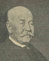
Dietrich von der Schulenburg,
District Administrator 1887–1899
Friedrich von Falkenhausen,
District Administrator 1899–1905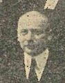
Edgar Loehrs,
District Administrator 1905–1917
Erich von Reden,
District Administrator 1917–1933
2.jpg&filetimestamp=20140926174736&)
3.jpg&filetimestamp=20140926175304&)
3.jpg&filetimestamp=20140926180021&)
2.jpg&filetimestamp=20140926180739&)
3.jpg&filetimestamp=20140926181412&)
4.jpg&filetimestamp=20140926181837&)
2.jpg&filetimestamp=20140926182525&)
.jpg&filetimestamp=20140926183851&)
2.jpg)
cities and communes
As of 1949
In 1949 the following cities and communities belonged to the district of Lübben:
Municipalities dissolved before 1939
- Behlow , 1921 on Lieberose
- Frauenberg , 1928 in Lübben
- Möllen , 1938 to Niewisch
- Mühlendorf , 1938 to Byhleguhre (then Geroburg )
- Münchhofe , 1939 on Lieberose
- New Byhleguhre , 1938 to Byhleguhre (then Geroburg )
- Sarkow , in Leißnitz in 1939
- Steinkirchen , 1939 in Lübben
- Schuhlen and Wiese , 1938 Schuhlen meadow together
Name changes
In some cases, place names of Sorbian origin under National Socialist rule in 1937 were verbally adjusted, translated or completely reinvented for ideological reasons, for example:
- Byhleguhre → Geroburg
- Byhlen → Waldseedorf
- Dobberbus → Doberburg
- Goyatz → callous hole
- Goschzschen → Goschen
- Sglietz → Glietz
- Skuhlen → Schuhlen
- Syckadel → Siegadel
- Wusswergk → Wußwerk .
The renaming of Byhleguhre, Byhlen and Goyatz was reversed after the Second World War.
literature
- Gustav Neumann : Geography of the Prussian State. 2nd edition, Volume 2, Berlin 1874, pp. 102-103, item 11.
- Royal Statistical Bureau: The municipalities and manor districts of the Prussian state and their population . Part II: Province of Brandenburg , Berlin 1873, pp. 192-199.
- Topographical-statistical manual of the government district of Frankfurt a. O. Verlag von Gustav Harnecker u. Co., 1867, pp. 191-205.
- Heinrich Berghaus : Land book of the Mark Brandenburg and the Markgrafthum Nieder-Lausitz , Volume 3, Brandenburg 1856, pp. 646-676 ( online ).
- Topographical-statistical overview of the government district of Frankfurt ad Oder. Compiled from official sources . Frankfurt ad cit. 1844, pp. 166-175.
- W. Riehl and J. Scheu (eds.): Berlin and the Mark Brandenburg with the Margraviate Nieder-Lausitz in their history and in their present existence . Berlin 1861, pp. 622-639.
- Walther Hubatsch (editor), Werner Vogel (editor Volume 5): Outline of German administrative history. Row A: Prussia. Volume 5: Brandenburg. Johann Gottfried Herder Institute, Marburg / Lahn 1975, ISBN 3-87969-117-7 , pp. 171-173.
- Michael Rademacher: German administrative history from the unification of the empire in 1871 to the reunification in 1990. Lübben district. (Online material for the dissertation, Osnabrück 2006).
Web links
- District of Lübben (Spreewald) - Territorial (Rolf Jehke, 2010).
Individual evidence
- ↑ a b c d e f g h Michael Rademacher: German administrative history: Landkreis Lübben. (No longer available online.) Archived from the original on March 25, 2016 ; Retrieved April 2, 2016 . Info: The archive link was inserted automatically and has not yet been checked. Please check the original and archive link according to the instructions and then remove this notice.
- ↑ a b Federal Statistical Office (ed.): Municipalities 1994 and their changes since 01.01.1948 in the new federal states . Metzler-Poeschel, Stuttgart 1995, ISBN 3-8246-0321-7 .
- ↑ a b Historical municipality register of the state of Brandenburg 1875 to 2000: Dahme-Spreewald district
- ^ Heinrich Berghaus: Land book of the Mark Brandenburg and the Markgrafthum Niederlausitz in the middle of the 19th century . Adolph Müller, Brandenburg 1854, chap. 3 VI., P. 44 ( digitized version [accessed on May 5, 2016]).
- ^ Carl Heinrich Ludwig Pölitz: History and Statistics of the Kingdom of Saxony . Hinrichs, Leipzig 1809, chap. State Constitution, p. 257 ( digitized version [accessed on May 5, 2016]).
- ^ Official Journal of the Royal Prussian Government in Frankfurt ad Oder . No. 12 , 1816, p. 107 ( digitized version [accessed on May 5, 2016]).
- ↑ genealogy.net: Lübben district
- ^ Christian Gottfried Daniel Stein: Handbook of Geography and Statistics of the Prussian State . Vossische Buchhandlung, Berlin 1819, The administrative district of Frankfurt, p. 210 ( digitized version [accessed on May 5, 2016]).
- ↑ Topographical-statistical overview of the administrative district of Frankfurt ad O., Harnecker, 1844, p. 30
- ^ The municipalities and manor districts of the Province of Brandenburg and their population in 1871
- ↑ 1946 census

Administrative districts: Frankfurt administrative district | Potsdam administrative district
City districts: Brandenburg an der Havel | Cottbus | Eberswalde | Forst (Lausitz) | Frankfurt (Oder) | Guben | Landsberg (Warthe) | Potsdam | Rathenow | Wittenberg
Districts: Angermünde | Beeskow-Storkow | Calau | Cottbus | Cross | Guben | Jüterbog-Luckenwalde | Königsberg Nm. | Landsberg (Warthe) | Lebus | Luebben | Luckau | Meseritz | Niederbarnim | Oberbarnim | East Havelland | Ostprignitz | Oststernberg | Prenzlau | Ruppin | Schwerin (Warta) | Soldin | Sorau | Spremberg | Teltow | Templin | West Havelland | Westprignitz | Weststernberg | Zauch-Belzig | Züllichau-Schwiebus
Dissolved in 1825 : Spremberg-Hoyerswerda , dissolved in 1827 : Frankfurt , dissolved in 1836 : Cüstrin | Teltow-Storkow , dissolved in 1873 : Sternberg , retired in 1881 : Berlin , in 1938 to the province of Pomerania : Arnswalde | Friedeberg Nm.