Schadow (Friedland)
|
Schadow
City of Friedland
Coordinates: 52 ° 2 ′ 43 ″ N , 14 ° 16 ′ 22 ″ E
|
|
|---|---|
| Height : | 75 m above sea level NHN |
| Area : | 4.48 km² |
| Residents : | 142 (December 31, 2016) |
| Population density : | 32 inhabitants / km² |
| Incorporation : | March 31, 2001 |
| Postal code : | 15848 |
| Area code : | 033671 |
|
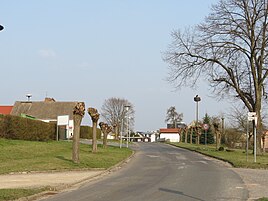
Dorfstrasse in Schadow
|
|
Schadow ( Lower Sorbian Škódow ) is a district of the city of Friedland in the Oder-Spree district in Brandenburg . Until it was incorporated into Friedland on March 31, 2001, Schadow was an independent municipality administered by the Friedland (Niederlausitz) office.
location
The village of Schadow is located in Niederlausitz , about seven kilometers north of Lieberose and south of Friedland. Surrounding villages are Karras in the north, the districts of Trebitz in the east, Goschen in the southeast and Doberburg in the south , which belong to the town of Lieberose in the district of Dahme-Spreewald , the district of Speichrow in the Schwielochsee municipality in the southwest, Pieskow in the west and Niewisch and Möllen in the northwest.
State road 434 runs through Schadow, via which the village is connected to federal road 168 to Cottbus, which runs about one kilometer to the east . The Pieskower Torfgraben flows south of Schadow .
history
Schadow was first mentioned in a document in 1388, although the place was already then called Schadow . The place name comes from Sorbian , but the meaning is unclear. Presumably it means bad meadow . In 1519 the Lieberose estate was sold by the von Köckritz family to the von Schulenburg family . The village of Schadow is also recorded as the place of this rule in the corresponding deed of purchase. In the following years the rule was inherited more and more until the von Schulenburg family was expropriated in 1945.
The topographical-statistical overview of the administrative district of Frankfurt ad O. from 1844 recorded 89 inhabitants in 13 residential buildings in Schadow for this year. The place had and does not have its own church and is parish in Niewisch . In 1867 there were 104 inhabitants in 14 buildings in the village.
Before 1815 Schadow belonged to the historical Krummspreeischen Kreis . As a result of the Congress of Vienna , Lower Lusatia, which previously belonged to the Kingdom of Saxony , came to the Kingdom of Prussia . Then the historical Krummspreeische Kreis was transformed into the district of Lübben and became part of the administrative district of Frankfurt in the province of Brandenburg . When the district was newly formed in the GDR on July 25, 1952, the Lübben district was greatly reduced in size, large parts of the district, including the Schadow community, were added to the Beeskow district in the Frankfurt (Oder) district. After the fall of the Berlin Wall , the Beeskow district was renamed the Beeskow district . During the district reform on December 6, 1993, the community of Schadow was assigned to the Oder-Spree district and administered there by the Friedland (Niederlausitz) office. This office was dissolved on March 31, 2001 and Schadow was incorporated into the city of Friedland together with the twelve other municipalities of the office .
Monuments
For Schadow there is a ground monument in the list of monuments of the state of Brandenburg :
- No. 90766 Corridor 1: German Middle Ages village center, Modern village center
Population development
| Population development in Schadow from 1875 to 2000 | |||||||||||||
|---|---|---|---|---|---|---|---|---|---|---|---|---|---|
| year | Residents | year | Residents | year | Residents | ||||||||
| 1875 | 93 | 1939 | 79 | 1981 | 111 | ||||||||
| 1890 | 89 | 1946 | 106 | 1985 | 123 | ||||||||
| 1910 | 83 | 1950 | 93 | 1989 | 137 | ||||||||
| 1925 | 84 | 1964 | 78 | 1995 | 137 | ||||||||
| 1933 | 81 | 1971 | 85 | 2000 | 139 | ||||||||
Web links
- Schadow on the side of the city of Friedland
- Schadow in the RBB program Landschleicher on September 10, 2000
Individual evidence
- ↑ Community and district directory of the state of Brandenburg. Land surveying and geographic base information Brandenburg (LGB), accessed on June 21, 2020.
- ^ Entry "Škódow" in the Lower Sorbian place name database on dolnoserbski.de
- ↑ Reinhard E. Fischer : The place names of the states of Brandenburg and Berlin: age - origin - meaning . be.bra Wissenschaft, 2005, p. 149 .
- ↑ Topographical-statistical overview of the administrative district of Frankfurt ad O. 1844, p. 173 ( bsb-muenchen.de ).
- ↑ Statistical Bureau of the Royal Government of Frankfurt a. O .: Topographical-statistical manual of the government district of Frankfurt a. O. Verlag von Gustav Harnecker u. Co., Frankfurt ad O. 1867, online at Google Books , p. 202
- ^ Schadow in the historical index of places. Retrieved June 14, 2018 .
- ↑ List of monuments of the state of Brandenburg: Landkreis Oder-Spree (PDF) Brandenburg State Office for Monument Preservation and State Archaeological Museum, accessed on June 14, 2018
- ^ Historical municipality register of the state of Brandenburg 1875 to 2005. (PDF; 331 KB) Landkreis Oder-Spree. State Office for Data Processing and Statistics State of Brandenburg, December 2006, accessed on June 1, 2018 .
