Göritz (Vetschau / Spreewald)
|
Göritz
Chórice City of Vetschau / Spreewald
Coordinates: 51 ° 48 ′ 6 ″ N , 14 ° 2 ′ 49 ″ E
|
|
|---|---|
| Height : | 64 m above sea level NN |
| Area : | 3.22 km² |
| Residents : | 186 (December 31, 2017) |
| Population density : | 58 inhabitants / km² |
| Incorporation : | December 31, 2001 |
| Postal code : | 03226 |
| Area code : | 035433 |
|
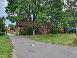
Historic farm buildings of the Göritz estate
|
|
Göritz , Chórice in Lower Sorbian , is a district of the town of Vetschau / Spreewald in the northeast of the Oberspreewald-Lausitz district in southern Brandenburg . Göritz is part of the official settlement area of the Sorbs / Wends .
location
Göritz is located in Lower Lusatia in the Spreewald . The place is surrounded by districts of Vetschau. In the northwest and north is Raddusch with his congregation parts Radduscher Buschmühlenteich and Radduscher Kaupen . Stradow and the Stradower ponds follow in the northeast . In the east lies the city of Vetschau / Spreewald. In the south are Koßwig and the former Dubrau desert .
history
Göritz was first mentioned in 1452 as Goritz . In 1484 it was called again as Goritz . The translation is accepted with a small mountain . However, this translation is not considered safe, as the Lower Sorbian name variant begins with ch . This was called Chorize in 1761 . The Sorbian name also allows a connection to the Old Sorbian Chorici with a connection to the personal name choir . The place name was mentioned in 1816 as Göritz and in 1880 as Chórice . The village was shaped by the Göritz manor . On the northern border of the village there was a water mill on the Göritzer Mühlenfließ.
After the Congress of Vienna Göritz came with the entire Lower Lusatia to the Kingdom of Prussia and belonged to the district of Calau . In 1880 at least 33.7 percent Sorbs lived in the village. After the Second World War, Göritz belonged to the Calau district, which was newly founded in 1952 . The site was partially devastated in 1986 by the Seese-Ost opencast mine . Three families, ten people, moved within the town due to the demolition. The place belongs to the church district Niederlausitz . On December 31, 2001, the village was incorporated into Vetschau together with the towns of Naundorf , Repten and Stradow .
Population development
| Population development in Göritz from 1875 to 2000 | |||||||||||||||||
|---|---|---|---|---|---|---|---|---|---|---|---|---|---|---|---|---|---|
| year | Residents | year | Residents | year | Residents | year | Residents | year | Residents | year | Residents | ||||||
| 1875 | 175 | 1933 | 150 | 1964 | 251 | 1989 | 182 | 1993 | 200 | 1997 | 197 | ||||||
| 1890 | 172 | 1939 | 134 | 1971 | 191 | 1990 | 178 | 1994 | 200 | 1998 | 199 | ||||||
| 1910 | 162 | 1946 | 216 | 1981 | 194 | 1991 | 194 | 1995 | 201 | 1999 | 214 | ||||||
| 1925 | 145 | 1950 | 211 | 1985 | 193 | 1992 | 193 | 1996 | 205 | 2000 | 200 | ||||||
Economy and Infrastructure
Federal autobahn 15 and state road 49 as well as the Berlin – Görlitz railway line run through Göritz . The nearest train stations are in Raddusch and Vetschau / Spreewald.
literature
- Frank Förster : Disappeared Villages - The demolitions of the Lusatian lignite mining area until 1993 . Domowina-Verlag, Bautzen 1995.
- Ernst Eichler : The place names of Niederlausitz . VEB Domowina-Verlag, Bautzen 1975.
Web links
- Homepage of the city of Vetschau / Spreewald - representation of the district of Göritz , accessed on November 30, 2009.
- Göritz in the RBB program Landschleicher on January 1, 2006
Individual evidence
- ↑ Development of the population of the city of Vetschau / Spreewald. In: vetschau.de. City of Vetschau, accessed on May 10, 2018 .
- ↑ StBA: Changes in the municipalities in Germany, see 2001
- ↑ Brandenburg Statistics (PDF)


