
Dammendorf (Grunow-Dammendorf)
|
Dammendorf
Community of Grunow-Dammendorf
Coordinates: 52 ° 8 ′ 33 ″ N , 14 ° 24 ′ 59 ″ E
|
|
|---|---|
| Height : | 66 m above sea level NN |
| Residents : | 236 (Dec. 31, 2006) |
| Incorporation : | October 26, 2003 |
| Postal code : | 15299 |
| Area code : | 033655 |
Dammendorf ( Lower Sorbian Domašojce ) is part of the municipality of Grunow-Dammendorf . The place is in the Oder-Spree district .
geography
Dammendorf is located in the heather and lake area of East Brandenburg, almost entirely in the Schlaubetal Nature Park . The area includes a network of meltwater channels in which the Schlaube , Oelse , Dorche and Demnitz flow. There are several lakes around Dammendorf: the Oelsener See , the Hammersee , the Kleine Schinkensee , the Große Schinkensee , the Langesee , the Große Treppelsee and the Kleine Treppelsee . There are bogs and swamps in the river's canyons.
The residential areas belonged to the district of Dammendorf:
- Forsthaus Wirchensee, 1 inhabitant in 2006
- Fulling mill , 3 residents in 2006
These living spaces now also belong to Grunow-Dammendorf, while the Jakobsee forester's house has been assigned to the community of Schlaubetal since the merger of the communities .
history
The first mention of dammendorff was on October 4, 1486 in a loan letter from Elector Johann von Brandenburg . The interpretation of the name Dammo is possible, but the Wendish origin is more likely : dam = oak. Place names like five oaks nearby seem to confirm this assumption. The spelling Domendorff can also be found in the 16th century.
The forest area in the former Friedländische Heide is decisive for the development of the Angerdorf and so Dammendorf including Heydereiterei were mentioned in a Pfandbrief as early as 1518 , when the guardians of Kaspars von Köckritz Castle and the city of Friedland and the associated villages to the order master of the Johanniter Georg von Schlabrendorff pledge. In 1533 the Friedland dominion was finally sold to the Johanniterordensmeister Veit von Thümen . Dammendorf and the forest district changed hands.
In 1542 there were already three whole farmers with three Hufen land each . Mention of Heidereiters Schwedler in 1563, who was killed in a box by a wood thief that year . The following Thirty Years' War devastated the village, from 1642 it was desolate and it was not until 1660 that the Schulzenamt was occupied again. The Heidereiterei was also practically unoccupied from 1631 to 1666.
In 1700 the office built a brick factory and in 1752 the first chief forestry was built. It was sacked by the Cossacks in 1759 during the Seven Years' War . School lessons took place around 1774 in neighboring Grunow . The existing village inn received a new half-timbered building in 1799 .
The replacement of all official residents took place due to the secularization in 1810 and in 1815 the Heidereiterei became a Prussian chief forester . Around 1820 there were 132 people living in the village, seven people in the watermill and the brickworks mentioned. In 1830, because of the large amount of windbreak , they were looking for wooden clubs for the district; the weekly wage that year was ten groschen for every fathom of pine , ten groschen and six pfennigs for every fathom oak . The old pine seed kiln was replaced by a new one in 1842 and a royal Prussian kiln master was used for quality assurance.
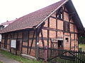
at the Dammendorf pine seed kiln
New building in 1842, Dammendorf pine seed kiln
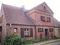
former school, today the heather and forest museum


In 1853 the place had a size of 2574 acres , the Dammendorfer forest area 11359 acres 162 square rods . The royal rent and police office and the forest treasury were located in the castle of the former Friedland office. The office and its castle went back to the time of the Friedland order. A brickyard and a forester's house also belonged to the town and district. In 1854 there was also an established tea oven . The population in Dammendorf including the forester's house Schakobsee (Jakobsee) had risen to 263 in 1856 and to ten people in the forester's house.
In 1870/1874 a daily wage of 1.10 marks was paid in the forestry office. A new construction of the forestry building became necessary in 1882. In 1905 the Protestant school was rebuilt and is now used as a heather and forest museum. In 1913 a two-family house was built for the forest workers . The Prussian Forestry Office building received a new building in 1927/1928, during the same period the pine seed kiln was converted into a house for forest workers.
With the end of the Second World War , the use of the forestry office building as a chief forester's location came to an end. The first female forest workers were trained in the Dammendorfer Revier in 1952/1953. In the forestry area, a state hunting ground for foreign originated diplomats and local officials . In 1989, the site was given a forest ranger's office again, and a new building was built for this.
The children were still taught in the same room from first to fourth grade in the 1905 school building. The older children ran to Grunow on foot. The town's school history only ended when a newly built elementary school opened in Fünfeichen in 1960 . From 1960 to 1972 a kindergarten was housed in the building. During this time an extension took place. In the fall of 1972 opened consumption , This lasted until about 1991, from 1995 the church now used the localities as mayor office. She renovated the building and had apartments built on the upper floor. After the construction of a new community center, the old community office remained unused. The Heimatverein was founded in 2008, and the Heidereiterei- and Forest Museum in the vacant rooms opened in June 2009.
Administrative history
Originally belonging to the district of Lübben (Spreewald) , Dammendorf was incorporated into the district of Frankfurt (Oder) from July 1, 1950 to July 24, 1952 . From July 25, 1952 to December 5, 1993, Dammendorf was a municipality in the Fürstenberg district, which was later renamed the Eisenhüttenstadt-Land district .
With the establishment of the office Schlaubetal , Dammendorf became a municipality of this office on June 23, 1992. Since October 26, 2003, the place is part of the community Grunow-Dammendorf.
Tourism and sightseeing
In addition to the Schlaubetal nature experience and excursions in the region, holidaymakers can use the Dammendorf trail riding base for trail riding with forest rangers. There are forest nature trails for those interested in the history of old professions. The designated hiking trails lead through a very varied terrain, overnight accommodation and restaurants are plentiful.
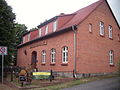
A forester's house and the former Dorfkrug are under monument protection .
Economy and Infrastructure
Schools are mainly used in Eisenhüttenstadt and Beeskow , further facilities are available in the neighboring town of Grunow.
Dammendorf is on the federal highway 246 , which connects Eisenhüttenstadt and Beeskow.
Grunow-Dammendorf is part of the Berlin-Brandenburg transport association . The BOS bus 400 is available for public transport . In the neighboring district of Grunow is the station of the same name, from which the regional train RB36 goes to Königs Wusterhausen or Frankfurt .
Personalities
- Max Kienitz (1849–1931), forest botanist and pioneer of nature conservation , completed a practical apprenticeship in the Dammendorf forest ranger's office from 1869–1870.
See also
Web links
- Dammendorf in the RBB program Landschleicher on November 6, 2016
Individual evidence
- ↑ VerfGBbg, decision of 21 April 2005 - VfGBbg 184/03 - [1] Constitutional Court of the Land Brandenburg
- ^ State government of Brandenburg [2] Territorial status: January 1, 2009
- ↑ Adolph Friedrich Riedel : Codex diplomaticus Brandenburgensis , collection of documents, chronicles and other sources for the history of the Mark Brandenburg and its rulers, main part 2, collection of documents on the history of the foreign relations of the Mark Brandenburg and its regents. Volume 5, Morin, Berlin 1848, p. 428
- ↑ Ernst Eichler : The place names of Niederlausitz. Domowina-Verlag, Bautzen 1975, p. 37
- ^ Siegfried Körner: Book of place names in Niederlausitz, studies on the toponymy of the Beeskow, Calau, Cottbus, Eisenhüttenstadt, Finsterwalde, Forst, Guben, Lübben, Luckau and Spremberg districts (= German-Slavic research on namology and settlement history, Volume 36). Akademie-Verlag December 1, 1993, ISBN 3050008369 , pp. 84, 86, 139
- ↑ Oskar Helpap: On the morphology of Niederlausitz (= Berlin geographical work, issue 8). J. Engelhorns Nach., Stuttgart 1935, p. 30
- ^ Adolph Friedrich Johann Riedel: Codex diplomaticus Brandenburgensis. Collection of documents, chronicles and other sources for the history of the Mark Brandenburg and its rulers, continued at the event of the Association for the History of the Mark Brandenburg, the first main part or the document collection for the local and special regional history, twentieth volume. G. Reimer, Berlin 1861, p. 335
- ↑ Rudolf Lehmann : The Lords in Lower Lusatia, Investigations into the Origin and History (= Central German Research, Volume 40). Böhlau, Cologne, Graz 1966, p. 40
- ↑ Götz von Houwald : The Niederlausitzer manors and their owners. Volume 3: District of Lübben. Degener & Co. Inh. Manfred Dreiss 1984, ISBN 3768641090 , p. 78
- ^ Association for the history of the Mark Brandenburg: Research on Brandenburg and Prussian history. Delivery by G. Kunze Bernburg, Berlin-Dahlem 1938, p. 189 Personalia of Heidereiter since 1563
- ↑ Julius Theodor Grunert: Forstliche Blätter, magazine for forest and hunting. Booklet 13 (About the preservation and breeding of oak in the Dammendorf forestry inspectorate, Forest Inspectorate Frankfurt-Lübben. A cultural-historical sketch. From Royal Prussia. Upper forester Brehmer zu Dammendorf near Friedland in Nieder-Lausitz), Julius Springer, Monbijouplatz 3, Berlin 1867 , P. 49
- ↑ Winfried Bliss: The planning chamber of the Frankfurt / Oder government, special inventory 1670 to 1870 (= publications from the archives of Prussian cultural property, volume 15). Böhlau, Cologne, Vienna 1978, ISBN 3412005789 , pp. 67, 98
- ↑ Alexander August Mützell, Dr. Leopold Krug: New topographical-statistical-geographical dictionary of the Prussian state. Volume 1: A-F. Karl August Kümmel, Halle 1821, p. 250
- ^ Official gazette of the Royal Liegnitz government in Silesia. Twentieth year 1830, printed in the Royal Court Printing House at E. Doench, Liegnitz 1830, p. 236 (notices from other authorities)
- ^ Heinrich Berghaus : Land book of the Mark Brandenburg and the Markgrafthum Nieder-Lausitz in the middle of the 19th century or a geographical-historical statistical description of the province of Brandenburg. Brandenburg 1854-1856, Volume 3, pp. 654, 655, 658
- ↑ Topographical overview of the localities in the department of the royal court. Decker, Berlin 1854, pp. 27, 86, 115
- ↑ Chancellery Güthlein: Topographical overview of the appellate court department Frankfurt a / O. Gustav Harnecker & Co, Frankfurt a / O 1856, p. XXXIII
- ^ Mark Spoerer: Tax burden, tax incidence and tax competition. Akademie-Verlag, 2004, ISBN 3050040882 , p. 213
- ↑ A dream comes true. In: Märkische Oderzeitung. December 6, 2008
- ↑ Law on the change to improve the district and community boundaries of April 28, 1950 of the People's Chamber of the GDR
- ↑ Municipalities 1994 and their changes since January 1, 1948 in the new federal states , Metzler-Poeschel publishing house, Stuttgart, 1995, ISBN 3-8246-0321-7 , publisher: Federal Statistical Office
- ^ StBA: Changes in the municipalities in Germany, see 2003
- ↑ The ride through the Schlaubetal. In: Märkische Oderzeitung. July 17, 2010
- ↑ BRAFONA edition 135, May / June / July 2008, rubric “Public Relations / Forest Education”, p. 30