
Rough
| coat of arms | Germany map | |
|---|---|---|

|
Coordinates: 52 ° 20 ' N , 14 ° 1' E |
|
| Basic data | ||
| State : | Brandenburg | |
| County : | Oder-Spree | |
| Office : | Spreenhagen | |
| Height : | 73 m above sea level NHN | |
| Area : | 21.59 km 2 | |
| Residents: | 2014 (Dec. 31, 2019) | |
| Population density : | 93 inhabitants per km 2 | |
| Postal code : | 15518 | |
| Area code : | 03361 | |
| License plate : | LOS, BSK, EH, FW | |
| Community key : | 12 0 67 408 | |
| Office administration address: | Hauptstrasse 13 15528 Spreenhagen |
|
| Mayor : | Sven Sprunghofer | |
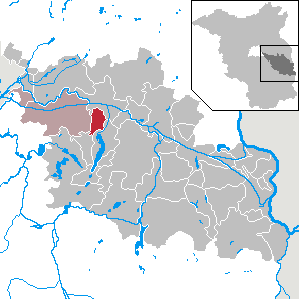
| Location of the municipality of Rauen in the Oder-Spree district | ||
  |
||

Rauen is a municipality in the Oder-Spree district in Brandenburg . She belongs to the Spreenhagen office .
geography
Rauen is an anger village and is located on the Rauener Mountains .
South of the town are known as natural monument protected, even Markgraf stones called Rauener stones . They are considered to be the largest erratic boulders in the Mark Brandenburg .
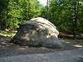
Rough stones

in the year 2005


Community structure
The inhabited part of the municipality Grauer Esel and the residential areas Forsthaus Rauen, Fuchsbau, Heidehof, Karlshöhe, Kiesweg, Stadtberg and Westend belong to Rauen.
history
The place was first mentioned in 1285. The name Rauen (from Ruwen ) means on the mountain slope and also a quiet, holy place .
Until the 18th century, the village was dominated by the fortified church and the farmsteads around the Anger . Due to its massive construction, the church served as a refuge and defense bastion. 14 farmers and one kötter lived in Rauen in 1518 ; Charges were only paid to the church. From 1631 to 1633, in the Thirty Years' War , the village was devastated and looted. In 1770 the first Büdner houses were built next to the Anger. Day laborers lived in them who ran a small farm as a sideline. From 1827 to 1829, brown coal fields were discovered in Rauen . The mining since 1842 and the settlement of miners from the Harz region largely determined the further development of Rauens. The coal mines were shut down in 1905 due to cheap railway tariffs and favorable hard coal prices. The land reform in 1945/1946 expropriated three large farmers . The land was distributed to resettlers and new farmers. By 1960 all farms joined the LPG .
Rauen belonged to the Beeskow-Storkow district in the province of Brandenburg since 1836 and to the Fürstenwalde district in the GDR district of Frankfurt (Oder) from 1952 . The community has been in the Oder-Spree district in Brandenburg since 1993.
Population development
|
|
|
|
|
Territory of the respective year, number of inhabitants: as of December 31 (from 1991), from 2011 based on the 2011 census
politics
Community representation
The community council of Rauen consists of 12 community representatives and the honorary mayor. The local election on May 26, 2019 resulted in the following distribution of seats:
| Party / group of voters | Seats |
|---|---|
| Lively rough | 4th |
| Movement for the rough | 4th |
| Rauen-Stadtberg-Westend-Kiesweg | 2 |
| SPD | 1 |
| Future rough | 1 |
mayor
- 1998-2003: Rosemarie Arenstedt
- 2003–2008: Eckart Kultus
- since 2008: Sven Sprunghofer
Sprunghofer was elected in the mayoral election on June 16, 2019 with 52.5% of the valid votes for a further term of five years.
coat of arms
The coat of arms was approved on November 17, 2000.
Blazon : "In silver, a green bar accompanied by a black granite bowl with three feet at the top and a green three-mountain at the bottom, topped with a tinned, golden church spire topped with black crosses."
The coat of arms was designed by the heraldist Frank Diemar .
Attractions

In the list of architectural monuments in Rauen and in the list of ground monuments in Rauen are the cultural monuments entered in the list of monuments of the state of Brandenburg.
- Rauen village church , field stone church from the first half of the 15th century, four carved figures in the interior from an altar from around 1480/1490
traffic
Rauen is on the L 361 state road between Storkow and Fürstenwalde .
Personalities
- Egon Wagenknecht (1908–2005), forest scientist, born in Rauen
literature
- Konrad Kilper: Where the big stones are. A rough man remembers. Verlag Die Furt, 2010, ISBN 978-3-939960-11-9 .
Web links
- Rough home & lookout tower club
- The geotope Markgrafensteine (pdf) ( Memento from January 11, 2006 in the Internet Archive )
- Office Spreenhagen
- Contribution to the RBB program Landschleicher on June 28, 2009
Individual evidence
- ↑ Population in the State of Brandenburg according to municipalities, offices and municipalities not subject to official registration on December 31, 2019 (XLSX file; 223 KB) (updated official population figures) ( help on this ).
- ^ Service portal of the state administration Brandenburg. Rauen community
- ^ Historical municipality register of the state of Brandenburg 1875 to 2005. Landkreis Oder-Spree , pp. 22-25.
- ↑ Population in the state of Brandenburg from 1991 to 2017 according to independent cities, districts and municipalities , Table 7
- ^ Office for Statistics Berlin-Brandenburg (Ed.): Statistical report AI 7, A II 3, A III 3. Population development and population status in the state of Brandenburg (respective editions of the month of December)
- ^ Result of the local election on May 26, 2019
- ↑ Results of the municipal elections in 1998 (mayoral elections) for the Oder-Spree district ( Memento of the original from April 12, 2018 in the Internet Archive ) Info: The archive link was automatically inserted and not yet checked. Please check the original and archive link according to the instructions and then remove this notice.
- ↑ Local elections October 26, 2003. Mayoral elections , p. 28.
- ↑ Local elections in the state of Brandenburg on September 28, 2008. Mayoral elections , p. 10.
- ↑ Brandenburg Local Election Act, Section 73 (1)
- ^ Result of the mayoral election on June 16, 2019
- ↑ Coat of arms information on the service portal of the state administration of Brandenburg
Bad Saarow | Beeskow | Berkenbrück | Briesen (Mark) | Brieskow-Finkenheerd | Diensdorf-Radlow | Eisenhüttenstadt | Erkner | Friedland | Fürstenwalde / Spree | Gosen-Neu Zittau | Gross Lindow | Grünheide (Mark) | Grunow-Dammendorf | Jacobsdorf | Long choice | Lawitz | Mixdorf | Garbage rose | Neißemünde | Neuzelle | Ragow-Merz | Rough | Reichenwalde | Rietz-Neuendorf | Schlaubetal | Schöneiche near Berlin | See you | Spreenhagen | Steinhöfel | Storkow (Mark) | Dive | Vogelsang | Wendisch Rietz | Wiesenau | Woltersdorf | Ziltendorf