Rough mountains
| Rough mountains | ||
|---|---|---|
|
Rauensche Berge, view from the north |
||
| Highest peak | nameless elevation ( 153 m above sea level ) | |
| location | Rauen , Fürstenwalde / Spree ( Brandenburg , Germany ) | |
|
|
||
| Coordinates | 52 ° 19 ′ N , 14 ° 2 ′ E | |
| rock | predominantly glacial material ( sand , gravel , bedload and boulders , boulder clay ), interspersed with late Tertiary clods and periglacial deposits | |
| Age of the rock | Saale Ice Age (approx. 140,000 years), overformed in the Vistula Ice Age (approx. 20,000 years), tertiary rocks older than 5 million years | |
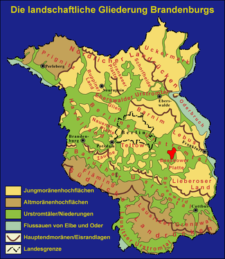
The Rauenschen Berge (also called Rauener Berge ) are named after the town of Rauen in Brandenburg . They are located south of Fürstenwalde / Spree and their highest point is 153 meters high. The Rauenschen Berge are famous and well known for the Margrave stones . The Rauenschen Berge are located in a wooded landscape and are located south of the Autobahn 12 (from Berlin to Frankfurt (Oder) and on to Poland ). In the Oder-Spree district , only the Hutberg is higher. South of Fürstenwalde / Spree is the former Fuchsbau bunker , which was the Bundeswehr base until 1994.
Geography and origin
The Rauenschen Berge are just south of the Berlin glacial valley . Like all of Brandenburg, they were formed during the Ice Age by the inland ice advancing from Scandinavia . It is true that they therefore mainly consist of glacial deposits (meltwater sand and glacial till ); a special feature, however, is the frequent occurrence of sediments from the Tertiary (sand and lignite ). They are evidence that the material from which the Rauenschen Mountains are made was intensely disturbed (compressed) by the pressure of the advancing glaciers, since deposits of the Tertiary are usually much deeper. According to the results of the boreholes, it is currently relatively certain that the Rauenschen Berge were decisively shaped as early as the penultimate Ice Age, the Saale Ice Age . The youngest ice, the soft ice age, has indeed passed over and reshaped the mountains; but the effect remained behind the ice from the time of the Saale. Therefore, the Rauenschen Berge cannot simply be called terminal moraine . The term compression moraine is more appropriate.
The margrave stones
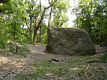
The Margrave Stones are located within the Rauenschen Mountains . It is about two boulders or debris that came from Scandinavia with the inland ice during the Ice Age . They are a popular attraction for day trippers and are known far beyond the region. In 2006 the margrave stones were included in the list of 77 awarded National Geotopes .
Mining
In the 18th century, several brown coal deposits were discovered in the Rauenen Mountains. After more detailed explorations in 1829 in the Schlangengrund and at the Teufelssee, mining began in 1842. The master bricklayer F. Schilling made the first prospecting application on April 26, 1841 at the Royal Mining Authority in Rüdersdorf. In the following years Conrad von Rappard took over this mine field . When the dismantling began, many Berliners moved to Rauen and the town's population doubled. From 1843 to 1874, 1,740,000 m³ of brown coal was mined in the Rauenschen Mountains. Mining in the Simon tunnel took place until 1924. After the Second World War, another mining area was opened in Petersdorf. This was operated until 1950. In the Rauenschen Mountains not only coal was mined, but also molding sand and clay. The pit lake and the clay pits in Bad Saarow are the legacies of this mining.
The Fuchsbau bunker in the northeastern part of the Rauenschen Berge was partially built over the tunnel systems from the time of lignite mining.
First order trigonometric point
Rauen, Rauener Berg (formerly "Colpiner Forst I"), is a first order definition of the German Main Triangle Network (DHDN). The first indications of the existence of a triangulation point on the Rauener Berg come from a newspaper report from the “Fürstenwalder Wochenblatt” from 1879. This report provides information about the existence of a heavily dilapidated tower. This temporal connection and the favorable geographical location indicate that the tower in question is a signal tower, the trigonometric point "Rauener Berg".
The survey-based proof of the origin of the Rauener Berg point shows that the 1st order point created in 1909 is identical to the earlier 2nd order point “Colpiner Forst I”. It is therefore undisputed that a second order triangulation point already existed in the same place before 1909. In the years 1908 to 1913, the triangulation point "Colpiner Forst I" was included in the triangulation of the connection chain Berlin-Schubin, used as an observation point and subsequently raised to point I. For this purpose a signal tower was erected from which the directions to Seefeld (today Poland), Treppeln (Hutberg), Biebersdorf (Marienberg), Stülpe (Golmberg), Torgelow (Dannenberg) and Berlin (town hall) were observed.
The center of the station Rauen "Colpiner Forst I" is the main point of the trigonometric network of the first order and became part of the Reich triangle network (RDN).
The point has retained its special significance in the more recent past. From 1945 to 1947, the former Institute for Earth Measurement in Bamberg calculated the Central European Network (ZEN). The ZEN is a frame network made up of selected triangular chains. The Reich triangular network provided the German share . The point "Colpiner Forst I" was the main point in the ZEN from 1950. Since the signal tower used in 1909 no longer existed, the necessary observations were carried out from the eccentric fire watchtower that was built for observation purposes.
In 1963, the observations and the set of directions from 1909 were related to the eccentric and used in a new network adjustment . In the course of this work, the trigonometric point "Colpiner Forst I" was renamed to "Rauen, Rauener Berg" .
In 1967 further angle measurements were carried out from the Rauener Berg as part of the German-Polish connection. In 1971 and 1974 astronomical observations to determine the azimuth according to "Dannenberg, Torgelow" were carried out using two different methods. The trigonometric point "Rauener Berg" was the main point of the first order in the Astronomical Geodetic Network (AGN) of 1983, the uniform network of the Eastern European countries. The importance of the point is undisputed to this day, so that its continuation remains indispensable. For this reason, the first order fixed points will also be maintained in the state of Brandenburg in the future.
Observation towers at the trigonometric point
In the Rauenen Mountains there were towers at different times that were often used as lookout points. The purpose of their establishment, however, lies in other causes; it is often the task of land surveying . A report in the “Fürstenwalder Wochenblatt” mentioned a badly dilapidated tower as early as 1879. The exposed location and the fact that signal towers for national surveying have been erected since around 1860 suggest that it was used for surveying purposes. This knowledge is not certain.
In 1907 the military treasury erected a 44 m high observation tower above the trigonometric point "Rauener Berg". The elaborate wooden construction consisted of twelve wooden pillars and contained an observation platform at a height of 28 m. From this observation tower, trigonometric measurements were carried out between 1908 and 1913 on the Berlin – Schubin link. The tower was released to the public as a lookout tower.
Since the beginning of the 20th century, there have been intensive efforts to build a Bismarck tower in the Rauenen Mountains. A citizens' association in Rauen planned the construction of a massive Bismarck tower made of stone, which was never realized due to lack of money. The trigonometric signal tower is sometimes referred to as the Bismarck tower in illustrations.
After the tower had become impassable due to a lightning strike in 1920, a new wooden tower was built on August 20, 1922. Although often referred to as a lookout tower, it was again used for triangulation . The tower had six pillars. The construction consisted of two three-sided pyramids; on the tips of which the signal and instrument platforms were anchored. It is not known how long this 21 m high observation and signal tower was used.
During the Second World War , there was evidence of a 35 m high wooden watchtower, which was provided with a pulpit for air space observation at a height of 30 m. Later a log house and a 50 to 60 m high square steel tower secured by tension ropes were added at the foot of the tower.
After the war, local wagoners cut the wire ropes. The steel tower collapsed after a storm in 1946. The wooden tower burned down from the pulpit.
The tower for forest fire observation erected in 1954 was demonstrably also used as an observation and signal tower for the national survey from 1955. The wooden tower with a fire watch had a height of 28 m. The increased use of the “Fuchsbaus” bunker in the Rauenschen Mountains (from 1960 by the Berlin air raid, from 1963 by the National People's Army ) led to the abandonment of forest fire observations. There were then structural changes to the tower.
The state survey documents show that observations from the fire watchtower, which is eccentric to the trigonometric point, have been carried out for various measurement campaigns since 1962. The wooden tower consisted of separate constructions for the lowest possible vibration construction of the surveying instrument on the one hand and the observer or the signal on the other. The observation platform was at a height of 22 m.
On 29 April 2000, this last existing in Brandenburg 25-meter observation tower was prepared by the Technical Relief blown up because it had no significance for the state survey and structural damage posed a growing threat.
After a development association in Rauen tried for several years to build a new lookout tower above the axis of the trigonometric point "Rauener Berg", the symbolic laying of the foundation stone took place on July 6, 2011 , although the work had already begun. The publicly accessible observation tower with a 39.70 meter high, uncovered steel structure was opened in September 2011.
literature
- Anna Plothow : The Rough Mountains . In: Märkische sketches . Berlin: Schall & Rentel n.d., pp. 150–162.
- K. Lemke & H. Müller: Natural monuments. Trees, rocks, waterfalls. 1st edition. Tourist guide. Berlin / Leipzig 1988, ISBN 3-350-00284-6 , 340 pp.
- W. Zwenger: The historical lignite mining in the Rauener Mountains near Fürstenwalde (Spree). In: Beeskower nat.wiss.Abh. 2. 1988, pp. 35-42.
- Local history of Heimatstube Rauen, as of May 2008
- Regina Scheer : Dealing with the monuments. A research in Brandenburg. Brandenburg State Center for Political Education, 1st edition 2003.
- Bernd Sorge: The observation tower in the Rauener Mountains was blown up. In: Measurement Brandenburg 02/2000
Web links
- Lookout tower & mining & ski hut in the Rauener Berge, Rauen-Heimatverein
- On the trail of mining in the Rauener Mountains
- Lookout and observation tower Rauener Berge (video)
Individual evidence
- ↑ Dieter Göllnitz: A Brandenburg wonder of the world - the boulder "Kleiner Markgrafenstein" near Fürstenwalde / Spree . In: Ernst-Rüdiger Look, Ludger Feldmann (Ed.): Fascination Geology. The most important geotopes in Germany , E. Schweizerbart'sche Verlagsbuchhandlung, Stuttgart 2006, ISBN 3-510-65219-3 , p. 34f.


