
Ziltendorf
| coat of arms | Germany map | |
|---|---|---|

|
Coordinates: 52 ° 12 ' N , 14 ° 37' E |
|
| Basic data | ||
| State : | Brandenburg | |
| County : | Oder-Spree | |
| Office : | Brieskow-Finkenheerd | |
| Height : | 29 m above sea level NHN | |
| Area : | 28.78 km 2 | |
| Residents: | 1478 (Dec. 31, 2019) | |
| Population density : | 51 inhabitants per km 2 | |
| Postal code : | 15295 | |
| Area code : | 033653 | |
| License plate : | LOS, BSK, EH, FW | |
| Community key : | 12 0 67 552 | |
| Community structure: | 3 districts | |
| Office administration address: | August-Bebel-Strasse 18a 15295 Brieskow-Finkenheerd |
|
| Website : | ||
| Mayor : | Danny Langhagel ( CDU ) | |
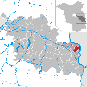
| Location of the community of Ziltendorf in the Oder-Spree district | ||
  |
||

Ziltendorf is a municipality in southeast Brandenburg in the Oder-Spree district . She belongs to the Brieskow-Finkenheerd office .
geography
The community lies on the edge of the Ziltendorfer Niederung , which is located in the Oder floodplain between the Oder-Spree Canal and the Oder . When the Oder floods in 1997 , large parts of the municipality were flooded, causing considerable damage.
Community structure
The Aurith and Ernst-Thälmann-Siedlung residential areas belong to the community .
history
The community was first mentioned in 1316 under the name Tzuluttendorph . From the old place names can be a high proportion of Sorbian peasants and Zeidler be closed at the medieval settlement. From 1406 to 1817 (with the exception of a six-year lease period) the village was owned by the Neuzelle Monastery , after which it belonged to the Guben district in the Prussian province of Brandenburg and from 1952 to the Fürstenberg (Oder) district - later Eisenhüttenstadt-Land in the GDR district Frankfurt (Oder) .
Population development

|
|
|
|
|
Territory of the respective year, number of inhabitants: as of December 31 (from 1991), from 2011 based on the 2011 census
politics
Community representation
The community council of Ziltendorf consists of 11 community representatives and the honorary mayor.
| Party / group of voters | Seats |
|---|---|
| CDU | 5 |
| Ziltendorfer Niederung voters' association | 2 |
| Individual applicant Stefan Lehmann | 1 |
| Individual applicant Axel Borchert | 1 |
| Individual applicant Marko Schäfer: 1 seat | 1 |
| SPD : 1 seat | 1 |
(As of: local election on May 26, 2019)
Stefan Lehmann's share of the vote corresponds to two seats. Therefore, according to § 48 (6) of the Brandenburg Local Election Act, a seat in the municipal council remains vacant.
mayor
- 1998-2014: Frank-Reiner Vierling (CDU)
- since 2014: Danny Langhagel (CDU)
Langhagel was elected in the mayoral election on May 26, 2019 with 68.0% of the valid votes for a further term of five years.
coat of arms
The coat of arms was approved on May 18, 1998.
Blazon : "In blue under a silver wavy bar a golden sheaf of corn, accompanied on the right by a golden trefoil cross and on the left by a golden double hook."
Sights and culture
In the list of monuments in Ziltendorf are the monuments entered in the list of monuments of the state of Brandenburg.
One of the sights of the village is the Protestant village church with its two church bells from the 14th and 16th centuries, which was rebuilt in the late 1990s after being completely destroyed in the Second World War .
In the community center, Bahnhofstr. 2, there is an exhibition on the Oder flood in 1997 .
- music
Ziltendorf brass band
Economy and Infrastructure
Ziltendorf has a developed commercial area in which further commercial settlements are possible. In addition, Ziltendorf is characterized by the agricultural use of the Ziltendorfer lowland.
Companies
- FeroTherm Thermolux GmbH
- SET up Computersysteme GmbH
traffic
Ziltendorf is located on the federal highway 112 between Frankfurt (Oder) and Eisenhüttenstadt and on the state road L 371 between Ziltendorf and the district of Aurith.
The station Ziltendorf is located on the railway line Frankfurt (Oder) -Guben-Cottbus and run by the local train line RB 11 ( Frankfurt (Oder) - Cottbus in) hourly operated. In addition, on the outskirts of the village there is the ArcelorMittal Eisenhüttenstadt work station with 16 tracks, which operates an integrated steelworks in neighboring Eisenhüttenstadt .
education
- Ziltendorf primary school
Sons and daughters of the church
- Erich Krüger (1894 – after 1945), politician (NSDAP)
- Georg Stein (1897–1976), zoologist
Web links
Individual evidence
- ↑ Population in the State of Brandenburg according to municipalities, offices and municipalities not subject to official registration on December 31, 2019 (XLSX file; 223 KB) (updated official population figures) ( help on this ).
- ^ Service portal of the state administration Brandenburg
- ^ Historical municipality register of the state of Brandenburg 1875 to 2005. Landkreis Oder-Spree (PDF) pp. 30–33
- ↑ Population in the state of Brandenburg from 1991 to 2015 according to independent cities, districts and municipalities , Table 7
- ^ Office for Statistics Berlin-Brandenburg (Ed.): Statistical report AI 7, A II 3, A III 3. Population development and population status in the state of Brandenburg (respective editions of the month of December)
- ^ Result of the local election on May 26, 2019
- ↑ Brandenburg Local Election Act, Section 48
- ↑ Results of the municipal elections in 1998 (mayoral elections) for the Oder-Spree district ( Memento of the original from April 12, 2018 in the Internet Archive ) Info: The archive link was automatically inserted and not yet checked. Please check the original and archive link according to the instructions and then remove this notice.
- ^ Result of the mayoral election on May 25, 2014
- ↑ Brandenburg Local Election Act, Section 73 (1)
- ^ Result of the mayoral election on May 26, 2019
- ↑ Coat of arms information on the service portal of the state administration of Brandenburg
Bad Saarow | Beeskow | Berkenbrück | Briesen (Mark) | Brieskow-Finkenheerd | Diensdorf-Radlow | Eisenhüttenstadt | Erkner | Friedland | Fürstenwalde / Spree | Gosen-Neu Zittau | Gross Lindow | Grünheide (Mark) | Grunow-Dammendorf | Jacobsdorf | Long choice | Lawitz | Mixdorf | Garbage rose | Neißemünde | Neuzelle | Ragow-Merz | Rough | Reichenwalde | Rietz-Neuendorf | Schlaubetal | Schöneiche near Berlin | See you | Spreenhagen | Steinhöfel | Storkow (Mark) | Dive | Vogelsang | Wendisch Rietz | Wiesenau | Woltersdorf | Ziltendorf