
Elbe-Elster-Land


The Elbe-Elster-Land (also Elbe-Elster-Area ) is a region in the triangle of the German federal states Brandenburg , Saxony-Anhalt and Saxony . It is part of the North German lowlands .
In older sources, northwestern parts of today's Elbe-Elster-Land are called Mezumroka - "land between the rivers". It was part of the Gau Nizizi and hardly populated.
A first written mention was the region as a "Elbe and Elster" on April 14, 1312 Frederick the free digestion in contract Tangermünde after his capture in Hayn , the Margrave Waldemar of Brandenburg 32,000 marks in silver to pay within three days promised . He also promised to cede his claims to the “land between Elbe and Elster”, the Lausitz region and the cities of Hayn and Torgau to the Brandenburg citizen.
At the time, the “land between the Elbe and Elster” was primarily understood to mean an area that included parts of the later Electoral Saxon offices of Mühlberg , Liebenwerda , Schweinitz and Lochau .
At the present time, mainly the area of the Elbe-Elster district, established in 1993, is being marketed and advertised for tourism as the Elbe-Elster-Land travel region , which also includes parts of Lower Lusatia around Finsterwalde to the west and the Schraden area.
Geography and natural space

Geographical location
The Elbe-Elster area is located in the triangle of the federal states Brandenburg, Saxony and Saxony-Anhalt. In its core area, it mainly comprises the eponymous lowland between the rivers Elbe and Schwarze Elster up to their confluence. In the present, parts of Niederlausitz around Finsterwalde and Sonnewalde (Altkreis Finsterwalde) as well as the Schraden area are included in the region due to the creation of the Elbe-Elster district in 1993 and its subsequent tourist marketing . Their borders are relatively fluid and merge into the neighboring regions, as the meaning of the term has been subject to constant change over the past centuries due to various changes in administrative borders.
The largest cities in the comparatively sparsely populated area are Finsterwalde, Lauchhammer and Jessen, but they do not go beyond small-town status. Other cities here include the district town of the Elbe-Elster Herzberg (Elster) district , the spa town of Bad Liebenwerda and Doberlug-Kirchhain , Elsterwerda , Falkenberg / Elster , Mühlberg / Elbe and Uebigau-Wahrenbrück .
Geology and surface shape

The surface shape of the region is characterized by a relatively flat landscape with smaller chains of hills, rivers and lakes, which were mainly formed in the Quaternary . The ice masses of the penultimate ice age left a typical moraine landscape . The region is therefore essentially divided into the two spatial units Elbe-Elster-Tiefland and the Lausitz basin and heathland . The Elbe-Elster lowland extends to the west of the region in the Lausitz glacial valley , part of the Breslau-Magdeburg-Bremer glacial valley , which was formed in the Saale Ice Age and which reaches its narrowest point in the Schraden valley between Elsterwerda and Merzdorf with a width of seven kilometers then swings to the northwest. Divided into three sections (Elbe-Elster area, east-west Elbe section, Magdeburg Elbe section), the Elbe-Elster lowland covers an area of around 1970 km². It extends in the area from the Elbe-Elster lowlands between Riesa on the Elbe in the south and Lauchhammer on the Schwarzen-Elster to south of the Saxony-Anhalt capital Magdeburg in the northwest. This cultural landscape is mainly characterized by open arable land, which is criss-crossed by the floodplains of the Elbe and Black Elster rivers, rich in forests and meadows. The Lusatian basin and heathland shape the eastern part of the region with their natural spaces "Kirchhain-Finsterwalder basin" and "Niederlausitzer Randhügel" (geologically speaking, the sands of the Lausitz land ridge ). In the north of the area, in the area of the town of Schönewalde , the administrative association Elbaue-Fläming and in the north of the office of Schlieben, foothills of the Fläming , a mountain range formed during the Ice Age , can be found as a natural boundary.
The highest natural elevation in the region is at 206.1 m above sea level. NN in the southeast, near the municipality of Val Gardena . This is a so-called geodetic point located directly behind the Brandenburg-Saxon border on the Heideberg . Here is with the heather height 201.4 m above sea level. NN also the highest natural elevation in the German state of Brandenburg . A geological peculiarity is the Rothsteiner Felsen , located about five kilometers north of Bad Liebenwerda , which is also Brandenburg's only larger natural stone cliff . During the most recent Ice Age , deep rock from the Cambrian period was exposed over a large area here. The rock, which essentially consists of silica sinter and chert , can be found in the region, in addition to Rothstein , in neighboring Prestewitz and in fish water on the surface of the earth.
Geotopes worthy of protection in the area of the Elbe-Elster-Land

The State Office for Geosciences and Raw Materials Brandenburg (today State Office for Mining, Geology and Raw Materials , LBGR) listed the following geotopes worthy of protection for the Elbe-Elster area in its "Atlas zur Geologie von Brandenburg" published in 2002 :
- Rothsteiner Felsen (natural outcrop of rock)
- Quartzite from Lugau / Fischwasser (natural outcrop of rock)
- Grauwacke Großthiemig (natural exposure of rock)
- Heideberg ( compression moraine )
- Silicified quartz sand in the Gotthold mine near Hohenleipisch (disused lignite mine)
- Briquette factory Louise (monument with geological reference)
- Parabolic dune north of Oppelhain
- Headwaters Kraupa
- Stream shrinkage near Kraupa
Natural resources

As in the entire area of southern Brandenburg, lignite is also widespread in the Elbe-Elster region and, alongside sand and gravel, is a frequently occurring mineral resource . It is present across the board both in the lowlands and in the higher parts of the lignite seams in varying thicknesses and depths . Until the fall of the Wall , a lot was obtained in open-cast mining and, in earlier times, also in civil engineering and then used for briquetting , coking , gas generation and power generation , the raw material hardly plays a role economically today.
Other important resources are near-surface mineral resources such as peat and clay as well as gravel and sand , which are extracted in active open-cast mining. The Mühlberg / Elbe site, where the Elbe gravel is extracted, is the most important nationwide . The size and quality make transport to more distant areas profitable. Other locations for gravel extraction include Haida and Zeischa on the Black Elster.
In the lowland areas there are also deposits of lawn iron stone , the larger deposits of which were already exploited in earlier times, especially for the operation of the Lauchhammer ironworks , which was built in 1725 .
The Doberlug-Kirchhain anthracite deposit is worth mentioning among the deep-lying mineral resources . This hard coal deposit of the highest quality coal is located at a depth of more than 200 meters and has an ash content of over 30 percent. Due to the limited size of the deposit, it is currently not worth mining, and future use by more modern mining technologies cannot be ruled out. There is also a uranium ore deposit not far from Herzberg (Elster) , which is currently not worth mining either.
Hydrography

The largest bodies of water in the area are the eponymous rivers Elbe and their tributary the Black Elster . Above all, the water system of the Black Elster, which flows into the Elbe 15 kilometers southeast of Wittenberg, dominates the region with its tributaries Pulsnitz , Große Röder , Kleine Elster , Schweinitzer Fließ and Kremitz and the associated extensive groundwater catchment area, both in the lowlands in the southwest as well as the higher areas in the northeast. The almost completely diked river, which once consisted of numerous rivers , is now one of the most narrowed rivers in Central Europe due to the massive river straightening that took place in the 19th century . In the 18th century the Elbe and Black Elster were connected by the Elsterwerda-Grödel-Raft Canal, which flows into the Neue Pulsnitz at Elsterwerda , shortly before it reaches 88.6 m above sea level. NN enters the Black Elster at river kilometer 71.09.
The mouth of the Pulsnitz, which is also known as Schraden, represents the border to Upper and Lower Lusatia in the southeast of the region and used to be very similar to today's Spreewald because of the numerous rivers that existed here at that time and the associated heavy swamp . With an area discharge of less than 150 millimeters per year, the Schraden is one of the poorest areas in Europe.
Other notable waters of the region are amongst others caused by gravel mining and erstwhile lignite mining emerged lakes in Bad Erna , in Green Lauch , Haida , lapwing , Zeischa , Mühlberg and Rückersdorf , and those being in the development located on Lusatian Lakeland belonging Bergheider lake in Lichterfeld .
Flora and fauna

The Elbe-Elster-Land is characterized by floodplain landscapes in the river basins of the Elbe and Schwarzer Elster water systems and extensive forest areas, of which the Liebenwerdaer Heide in the east and the Annaburger Heide in the northwest of the region are the most important due to their size.
Once used intensively for military purposes and thus largely shielded from the outside world, some of these have still been able to retain their original character. Characteristic animals of the region are, for example, cranes , gray geese, Elbe beavers, otters and various water birds that inhabit the floodplains and lake areas. In addition, wolf activities have recently been detected again in the Annaburg Heath . In the Liebenwerdaer Heide there are intensive efforts, which here until the 1980s existing capercaillie to resettle. As part of a pilot project led by the biologist Uwe Lindner, 27 female animals were released into the wild in May 2012 in the Forsthaus Prösa nature reserve .
Protected areas


The largest protected area in the area is the Niederlausitzer Heidelandschaft nature park with 484 square kilometers . It extends to around 95% in the Elbe-Elster district and also includes parts of the Oberspreewald-Lausitz district to the east . The heart of the nature park is the former military training area in the Liebenwerdaer Heide, which is characterized by stands of sessile oak, extensive heather areas and silver grass. Among other things, it serves the uniform maintenance and preservation of the near-natural landscape areas and the historically grown cultural landscape in this area. The area's post-mining landscapes are to be reclaimed for nature conservation and recreational use.
The Elsteraue conservation area, which covers around 6011 hectares, is located on the course of the Black Elster . It is divided into three ecological units and covers almost the entire Elsteraue between Lauchhammer and Herzberg (Elster). Likewise, a large part of the lower reaches of the Black Elster from Jessen to the confluence through the nature reserve "Untere Black Elster" (442 ha), which is part of the Middle Elbe Biosphere Reserve, and a large part of the floodplain landscape on the Elbe in Saxony-Anhalt are protected.
In the far south, in the Schraden area, lies the Merzdorf - Hirschfelder Waldhöhen landscape protection area, which has existed since 1968 . It serves to protect and maintain the terminal moraine between the places Merzdorf and Hirschfeld, in which Brandenburg's highest elevation, the 201.4 meter high heath is located.
Other landscape protection areas include the LSG Nexdorf-Kirchhainer forest landscape (4253 ha), which is characterized by the old mining around Tröbitz and Domsdorf, the LSG Rückersdorf-Drößiger Heide (3253 ha) on the southern edge of the Kirchhain-Finsterwald basin (3253 ha) and the LSG Hohenleipisch Sornoer old moraine landscape (10,510 ha), which places a large part of the landscape of the Liebenwerdaer Heide with the Hohenleipischer plateau, the moorland Loben and the post-mining landscapes in the Plessaer Heide under protection.
There are also numerous nature reserves in the region, 13 of them in the Niederlausitzer Heidelandschaft nature park. Protected areas worth mentioning here are, for example, the Alte Röder nature reserve near Prieschka , which among other things serves to preserve and develop this area as a habitat for the Elbe beaver , the Loben bog near Hohenleipisch or the Forsthaus Prösa nature reserve with one of the largest contiguous sessile oak forests in Central Europe.

climate
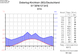
Climate diagram of Doberlug-Kirchhain

Climate diagram of Torgau
-Deutschland.png)
-Deutschland.png)
With its humid climate , the Elbe-Elster-Land lies in the cool, temperate climate zone , but a transition to the continental climate is noticeable.
Weather stations are located in Doberlug-Kirchhain and in Torgau on the Elbe . The month with the least rainfall is February, the wettest month in Doberlug-Kirchhain is July with an average of 69 millimeters, in Torgau it is August, where an average of 64 millimeters of precipitation falls. The average annual rainfall in Doberlug-Kirchhain is 561 millimeters, in Torgau 541 millimeters. The mean annual air temperature is 8.5 ° C in Doberlug-Kirchhain and 8.7 ° C in Torgau. The temperature difference between the coldest month of January and the warmest month of July is 18.4 ° C in Doberlug-Kirchhain and 18.7 ° C in Torgau.
history


Prehistory and early history
For the Elbe-Elster-Land it is assumed that there was only a moderate population density during the Stone Age. There are archaeological finds for about the area of Malitschkendorf, in which, among other things, stem tips from the end of the Old Stone Age (approx. 8000 BC) have been preserved. Smaller sites from the Mesolithic are near the Black Elster near Herzberg , Zeischa and in Schraden .
For the Bronze Age , there was evidence of a high density of settlements and burial mounds for the region along the rivers. So only in 2006 were new finds at the train station and in 2010 at a primary school in Doberlug-Kirchhain from the time 1000 BC. Made during the Lausitz culture . Only a few are still visible on the surface, as most of them were destroyed by agriculture. In addition to the ramparts at Falkenberg , Gerbisbach and Kosilenzien , the “Schweinert” barrow field at Uebigau is still preserved. The castle wall near Malitschkendorf was probably only built in the Early Iron Age , although there are traces of the Early Bronze Age in addition to the castle wall.
Settlement history
At the time of Charlemagne , the Franconian Empire extended to the Saale and Elbe . The country east of the Elbe and the Black Elster was sporadically inhabited by Slavs . With the successful campaigns of Gero against the Slavs, the Saxon East Mark was created . The Elbe-Elster-Land made up a large part of the Gau Nizizi, which is located in the Ostmark . Until then, the area was also called Mezumroka (Old Sorbian: between the marshes, borderland).
In the second half of the 10th century, the Elbe-Elster area became part of the Ostmark and thus incorporated into the German Empire. At that time only smaller Slavic tribes lived mostly in the outskirts of the area. The heartland was barely inhabited. With the creation of Burgwart centers, German settlers came to the country. The first castles were often built on old Slavic castles, such as the castles Klöden (965), Prettin (981), Zwethau (1004) and on the archaeologically secured castle wall Mühlberg / Elbe, mentioned in the imperial documents . With the later state expansion in the 12th century, these Burgwart centers lost their importance and now functioned as village ministerial seats. However, Mühlberg Castle was able to retain its importance as an originally margravial castle.
After the fall of Henry the Lion in 1180, the land around Wittenberg became part of the Duchy of Saxony , which was connected to the Reichsmarschallamt . About Bernhard III. it now belonged to the domain of the Ascanians . Further north, Albrecht the Bear, as Margrave of Brandenburg and Bishop Wichmann , had previously advertised farmers and citizens in the Rhineland , Flanders , Saxony and Franconia for settlement areas in the East Elbe.
The trade on the long-distance trade routes from Magdeburg and Zerbst via Wittenberg led to the area of the Black Elster and further to Niederlausitz or Meißen . Market towns and villages now grew quickly. Proof of this are, among other things, the Nikolaikirchen , named after the patron saint of traveling merchants , which can often be found along the streets.
In the south, the Naumburg bishops began to expand their rule in the Elbe-Elster area. The basis for this was a donation in 1064 and 1065 by King Heinrich IV , which included the castle watchdog in Strehla , Gröba and Boritz . After Otto's death (1190) the king took over the Mark Meissen as a settled imperial fief (1195), with which the area south of the Elbe-Elster-Land was now administered by royal officials. At the same time, this area became part of the Central German Reich territory, which probably extended to Lower Lusatia. Central power had thus triumphed over particular forces. But with the sudden death of the king in 1197, the Wettins managed to gain considerable power after a short time. For example, the Wettin Dietrich der Bedretztte took over the Lower Lusatia region in 1210 after another line of the Wettins died out with the death of Konrad II . The originally agreed payment of 15,000 marks was reduced by a third. The Wettiner now began hurriedly expand the area in which they did in the Bailiwick districts broke down. This usually resulted in a castle next to a fortified city, which was the seat of the sovereign bailiff. Trade, traffic and the expansion of new roads and paths were promoted, as was the founding of new cities.
The regulations in the Upper Lusatian border document also extend to the Elbe-Elster region. At this time, German settlements emerged around Dobrilugk. For example, 1228 Lugau and Lindenau, 1229 Frankena and Münchhausen, 1231 Gruhno and 1234 others. Already under Dietrich II , i.e. between 1165 and 1184, monks from the Thuringian monastery of Volkenroda founded the monastery Dobrilugk .
Around 1200 castles were built in Mückenberg , Elsterwerda , Saathain , Liebenwerda , Würdenhain , Wahrenbrück and Uebigau on the left bank of the Black Elster within a few decades . The only surviving watch tower from this period is the Lubwart Tower in Bad Liebenwerda. The castles served to secure the river crossings, but also to protect and control the military and trade routes that ran parallel to the Black Elster .


The nobility, which was under the rule of Wettin, tried to found a town. For example Messrs. Ileburg (later also Eulenburg), who in 1295 owned coins and Jews from their cities Mühlberg and Liebenwerda. This noble family, commissioned by the Wettins, took over the administration and management of numerous places between Eilenburg and Niederlausitz as a family of ministers . The Ileburgers succeeded in inheriting the managed goods in their possession. Due to the strategic location of the Elbe-Elster-Land between the Brandenburg and Meißen brands, their loyalty sometimes belonged to one margrave, sometimes to the other. The Counts of Brehna played an important role in the settlement of the northern part of the Elbe-Elster region . Around 1200, the Counts of Brehna resided first in Löben , later in Herzberg .
In 1290 Rudolf I received the County of Brehna, with which the Elbe-Elster-Land was now also transferred to the Duchy of Saxony-Wittenberg , which was to become the home of the later Electorate of Saxony . The Elbe-Elster-Land was first mentioned in a document on April 14, 1312, when Frederick the Freidige promised to pay 32,000 silver marks within three days after his capture with Hayn , Margrave Waldemar of Brandenburg , in the Treaty of Tangermünde . He also promised the Lausitz mark to cede the land between the Elbe and Elster (also Osterland) and the cities of Hayn and Torgau to the Brandenburg citizen. At the time, Elbe-Elster-Land was primarily understood to mean the area of the later Electoral Saxon offices of Mühlberg , Liebenwerda , Schweinitz , Lochau and Schlieben . The Lower Lausitz was not counted with the Elbe-Elster-Land.
The last Ascanian was Albrecht III. (Albrecht the Poor) , who died of his injuries in 1422 after a fire in his accommodation in the Lochauer Heide . His widow, Euphemia von Oels , moved into her Wittum in Liebenwerda Castle and expanded it in the following years to include the pre-castle. Wahrenbrück and other villages, such as Hohenleipisch , Lausitz and Berga bei Schlieben , from which they received taxes and natural deliveries, also belonged to their Wittum .
The Leipzig division in 1485 also divided the Elbe-Elster-Land. The areas around Mühlberg and Elsterwerda became part of the areas ruled by the Albertines , everything north of Liebenwerda to Wittenberg were now part of the lands ruled by the Ernestines .
reformation

The Electorate of Saxony was then transferred in 1423 by the Roman-German King Sigismund to the Wettin Margrave Friedrich the Warrior of Meissen and Thuringia for his fight against the Hussites as a fief. Only a few years earlier had Schliebener John of Drändorf , one of the most active supporters of the German Hussitism, his fight for the reformed faith begun. Martin Luther and Philipp Melanchthon later recalled his martyrdom and viewed him as a pioneer of the Reformation.
The proximity to Wittenberg also brought a proximity to the Reformation. After an escaped nun had married the pastor Hartmann Ibach from Sonnewalde, signs of disintegration soon appeared in the Mühlberg nunnery. The requested extradition of the two was refused in 1524 by the von Minkwitz brothers. The Sonnewald lords of Minkwitz were supporters of the modern doctrine. In 1525 Luther wrote to him about the reorganization of the divine service. The Mühlberg provost Georg Koeler also left the monastery to take up a pastor's post in Ernestine Liebenwerda. In 1526 Koeler asked for leave of absence to begin studying the Bible in Wittenberg . Luther himself repeatedly pushed ahead with the filling of the pastorate. In 1524 he recommended Johannes Buchner (Heller) as a deacon in Jessen, and in 1544 he introduced Martinus Gilbert de Spaignarts, a French Lutheran , as superintendent in Liebenwerda. Luther met Karl von Miltitz twice in the Elbe-Elster-Land, in October 1519 in Liebenwerda and a year later in the Antoniterkloster Lichtenberg near Prettin . In Herzberg / Elster, the Protestant church service in German was introduced by Johannes Wagner as early as 1522. Martin Luther took part in the school and church visits in Herzberg in 1522 and 1533. Two full-length portraits from the end of the 16th century by Martin Luther and Philipp Melanchthon are still in the possession of the Marienkirche today . Melanchthon wrote school regulations for the Herzberger Gymnasium in 1538, which were adopted throughout Germany in the course of the 16th century. Johannes Clajus , from Herzberg, wrote the “Grammatica Germanicae Linguae” in 1578, a pioneer of German grammar .
In the 16th century the Elbe-Elster-Land gained importance as an electoral hunting area. Signs of this are the construction of the Annaburg hunting lodge and the renovation of the castle in Liebenwerda . More locks followed.
Schmalkaldic War

The Schmalkaldic War came to an end with the outcome of the Battle of Mühlberg , during which the Protestant leader, Elector Johann Friedrich von Sachsen , was taken prisoner in the Elbe-Elster-Land near Falkenberg on April 24, 1547 . After the Wittenberg surrender , the Ernestine part of the Elbe-Elster country fell to Moritz von Sachsen , who already owned the areas between Mühlberg and Elsterwerda. The electoral dignity was also passed on to Moritz, as the office of arch marshal was connected with the takeover of the Duke of Saxony's home territory .
Moritz now began to redistribute his empire, and so the Kurkreis with its capital Wittenberg was created . The districts also included the Liebenwerda , Pretzsch , Seyda , Schlieben , Schweinitz and the Sonnewalde and Baruth authorities . On the other hand, the southern and eastern parts of the Elbe-Elster country were found in the Meißnischer Kreis , namely in the offices of Hayn , Mühlberg , Senftenberg and Finsterwalde .
Thirty Years' War

Until the Swedish War , the Elbe-Elster-Land was spared direct effects of the war. The army taxes, equipment and arms deliveries that were demanded from the towns and villages, however, were a great burden, and the troops passing through had to be supplied. Liebenwerda had to set up a team as early as 1614, whose equipment cost 750 guilders. When the city had to send the team to Bautzen and Sonnewalde in 1623, the council paid a further 1132 guilders wages. So now many cities had to pay for the formation and equipment of teams, in Torgau, for example, 1235 guilders for the pay. In addition to the normal state taxes, there were constant new delivery orders for bread, grain and oats. For example, the city of Liebenwerda once had to deliver over one hundred hundredweight of bread within three days. In addition, the council was instructed to take the bread away from the citizens in order to be able to bring the required amount at all. The cities had to borrow more and more money, for example from the churches, to meet the demands. Nevertheless, they owed taxes to their sovereigns.
With the Swedish War in the summer of 1631, a Croatian troop from Lusatia invaded the Elbe-Elster-Land for the first time, plundered villages and burned the village of Wiederau and the town of Uebigau. Wahrenbrück was also robbed and largely cremated. The military leader of the Catholic League, Johann t'Serclaes von Tilly , moved from Ortrand to Finsterwalde in the same year and left behind a looted land. Also in 1631 Schlieben was destroyed by the troops of Emperor Ferdinand II.
Herzberg, which was protected at that time by an extensive river and rift system, is one of the few German cities that could not be conquered during the Thirty Years' War . However, the region suffered severe devastation from wandering war people. The Elbe-Elster area was particularly hard hit in 1637 when the Swedish troops of General Johan Banér captured Torgau in January and camped there until early summer. They roamed the neighboring Elbe-Elster-Land, plundered the places and set them on fire. The traces of the Thirty Years' War were still visible in the towns and villages for a long time.
In addition to Herzberg, the city of Sonnewalde also withstood the sieges of various troops for a long time, around 1635 the siege of General Baner. People fled with their belongings, especially with their cattle, from the areas around Finsterwalde, Dobrilugk and Liebenwerda to Sonnewalde. It was not until April 1642 that the defenders under Kottwitz had to give up the city because of treason. The Sallgast castle was besieged by Swedish troops, but was not taken.
In addition to the consequences of the war, the residents of the area also suffered from the plague , which struck the region in several major epidemics . At the end of the war, some villages fell desolate , in all other places many Hufen lay desolate for decades and were only gradually taken over by local and newly immigrated settlers.
Seven Years War

The years of marching through the troops , billeting and looting of large parts of the Elbe-Elster region, especially by Prussian troops, led to great tensions. Since 1758 it was the troops of Friedrich August von Finck who in the villages around Mühlberg often only left the clothes that they wore on the body. The church treasury was also stolen.
The forced recruitment of the Prussians was often dramatic. While around 1753 30 farmer sons could still be forcibly recruited in Hohenleipisch, the recruiting in 1763 was less successful, as all sons capable of military service fled to the heath. The Prussians took their fathers and mothers hostage and tortured them. Often people fled as soon as the Prussian troops came, which the military replied with arson . In October 1760, parts of the Austrian Stampa regiment and Croats from General Ried's corps were encamped in the town of Uebigau . The arable citizens and farmers lost all hay and grain to the occupiers. An officer had the mayor and respected citizens publicly ill-treated. On February 20, 1760, the Prussian 4th Cuirassier Regiment met Austrian troops near Koßdorf. In the same year, the Battle of Torgau took place, in which the Prussians won after heavy losses. Thereafter, until the peace in 1763, the occupied territories continued to be plagued by Prussian troops with high demands for contributions .
Wars of Liberation

During the Wars of Liberation , large units of troops camped here again and again or passed through. After the failed Russian campaign in 1812 , Napoleon's soldiers were retreating through the country. In Liebenwerda, the French grave, a burial mound on the outskirts of the city at that time, reminds of this time. Shortly before the Battle of the Nations near Leipzig , the corps of Generals Dobschütz and Tauentzien with 30,000 men took quarters for ten days in the city of Liebenwerda. Around the same time, from September 28 to 30, 1813, Gebhard Leberecht von Blücher's corps with 30,000 men was encamped in nearby Elsterwerda and Kotschka. In October 1813 the headquarters of Blücher , Yorck and Tauentzien were in Jessen Castle. On January 13, 1814, the storming of Wittenberg by Allied troops began.
Prussian time


In the spring of 1815, due to the regulations made at the Congress of Vienna , the Elbe-Elster-Land was placed under Prussian rule . In 1816 the Liebenwerda , Mühlberg and parts of the Hayn office became the Prussian district of Liebenwerda , while the offices of Schlieben , Seyda , Schweinitz , Annaburg and Pretzsch became the Schweinitz district . Both districts were subordinate to the administrative district of Merseburg of the province of Saxony . The Niederlausitz offices of Dobrilugk , Finsterwalde and Sonnewalde were assigned to the district of Luckau , which belonged to the administrative district of Frankfurt in the province of Brandenburg .
In the middle of the 19th century, industrialization also began in the Elbe-Elster-Land . Above all, the lignite deposits discovered in the region around Plessa / Lauchhammer and Tröbitz quickly gained in importance, which with a stronger connection to the surrounding area and to industrial centers such as Berlin, Dresden , Leipzig and Wittenberg in the form of the expansion of the country roads, the construction of the railway lines and others Improvements in infrastructure went hand in hand .
One project that affected the entire region was initially the straightening of the Black Elster , which began near Zeischa in 1852 . Within eleven years, the river, which until then consisted of numerous rivers , was completely re-diked over a length of 90 kilometers. Through this measure, in which up to 1,200 workers were deployed at times, the Black Elster is still one of the most narrowed rivers in Central Europe .
Shortly thereafter, railway construction shaped the region. The railway line from Riesa to Jüterbog had already been built by the Berlin-Anhaltische Eisenbahn-Gesellschaft in 1848 , creating a connection to the Leipzig – Dresden line , which is considered the first German long-distance railway. From 1871, the Falkenberg / Elster-Cottbus (1871), Halle-Eilenburg-Falkenberg / Elster (1872), Falkenberg / Elster-Kohlfurt (1874), Falkenberg / Elster-Wittenberg (1875), Berlin-Dresden and Falkenberg / Elster-Wittenberg routes followed within a very short time Elsterwerda-Riesa (1875). Railway junctions were built in Falkenberg / Elster, Doberlug-Kirchhain and Elsterwerda / Biehla, whereby Falkenberg / Elster was to become one of the most important railway crossings in Germany. Five, with the railway line to Uckro opened in 1898, even six, railway lines were connected with one another. It finally brought the former village town charter , as the town experienced steady growth due to the railroad through the influx of residents and the settlement of industrial companies. The historical connection from the Black Elster to the Elbe, the Elsterwerda-Grödel raft canal built in the middle of the 18th century , lost its importance due to the construction of the railway. Several plans to build a large shipping canal from the Elbe via the Schwarze Elster and Spree to the Oder, including the raft canal, were never implemented.
In many other places in the region, too, but especially in the cities, the number of inhabitants has now increased. In the drapery town of Finsterwalde, for example, the population increased from 7,690 to 16,456 in the period from 1879 to 1933, in Elsterwerda from 3,193 to 8,738, in Bad Liebenwerda from 3,025 to 3,571 and in Herzberg from 4,009 to 4,263. This development affected most of those in the Far East of the Elbe-Elster-Land, the town of Mückenberg , which is characterized by lignite mining, is now Lauchhammer. Here the population grew from 4627 inhabitants by the beginning of National Socialism in 1933 to 19,734. The two cities of Doberlug and Kirchhain, where the white tanning industry was established, also saw strong growth in population (Doberlug grew from 1696 to 2149 inhabitants and Kirchhain from 3264 to 5627), which later led to the merger of the two cities into today's Doberlug-Kirchhain led.
While places such as Mückenberg, Finsterwalde, Falkenberg / Elster and Elsterwerda developed into industrial centers in the largely agricultural region, the spa system began to develop in Liebenwerda and Herzberg. In both cities, spa houses were built in which moor, steam, water and shower baths were administered. The moor required for this was brought in by means of horse and carts from nearby storage sites in “Loben” near Hohenleipisch or Kolochau and Polzen. Liebenwerda has been able to call itself " Bad " since 1925 .
The emerging regional economy achieved pioneering achievements, such as the construction of the first high-voltage line with an operating voltage of over 100 kV in Europe in 1912 , the 110-kV line from Lauchhammer to Riesa . The construction of the world's first overburden conveyor bridge in 1924 in the “Agnes” lignite mine in Plessa based on plans by the mine director Friedrich von Delius revolutionized mining. Three years later, one of the most modern peak load power plants of the time went into operation in the immediate vicinity .
National Socialism and World War II


The seizure of power by the National Socialists in 1933 initially went hand in hand with the appointment of people and functionaries loyal to the regime to key positions in politics, administration, industry and public life. Rigorous action was taken against the Jewish population, such as the Finsterwald merchant family Galliner, who had to sell their department store after harassment and slander , communists and other opponents of the regime and critics. The Saathain pastor Wolfgang Bastian fell victim to a denunciation and the Domsdorf socialist Max Borrack was executed in the Brandenburg-Görden prison for alleged high treason . Others were deported to prisons and concentration camps, where they served long sentences or died.
In the run-up to the Second World War, the construction and expansion of regional military facilities took place. In Hohenleipisch , for example, in the protection of the vast forests of the Liebenwerdaer Heide, an air ammunition plant was built from 1936 to supply the military airfields in the area in Finsterwalde , Großenhain and Alt-Lönnewitz with ammunition and bomb supplies.
In 1939 the Deutschlandsender III was put into operation in Herzberg . The associated antenna mast was at that time with a total height of 337 meters after the Empire State Building the second tallest structure on earth . Concentration and prisoner-of-war camps were set up, such as in Schlieben, where from 1938 a subcamp of the Buchenwald concentration camp existed in the Berga district , which served the armaments company "Hasag Hugo Schneider AG" as a supplier of prisoners for forced labor . 217 prisoners lost their lives until the camp was closed in April 1945. In 1939 the Wehrmacht set up the prisoner-of-war camp, main camp IV B near Neuburxdorf , which was prepared for 16,000 men at the same time and in which 3,000 people died by the end of the Second World War. Forced laborers were soon deployed in the industrial and agricultural enterprises too, some of whom had to replace the workers who had been drafted into military service. In Annaburg, Indian prisoners of war began to be recruited for the Free India Legion, which was subordinate to the Wehrmacht .
The end of the Second World War was accompanied by Allied bombing raids on industrial companies and infrastructure. The cities and railway systems were particularly affected. In the last days of the war, the region became an intermediate land between the fronts rolling towards each other from the west and east. The miners' community Plessa im Schraden was hit badly in those days , in which the advancing Red Army burned 724 buildings after heavy resistance from the forces of the 10th SS Panzer Division "Frundsberg" moving through the town . 155 inhabitants of the village died between April 22 and 25, 1945.
During this time stranded in the municipality Tröbitz after an odyssey through still unoccupied parts of Germany also over 2,000 so-called " exchange Jews occupied" train from the concentration camp Bergen-Belsen . On April 23, 1945, advancing Red Army troops found the train, which later became known as the Lost Train , and freed the prisoners, over 200 of whom had not survived the journey. In the weeks that followed, another 320 people died from the aftermath of transporting deaths from an epidemic .

Two days later, US and Soviet troops first met on German soil a few kilometers to the south . On the morning of April 25, 1945, an American patrol led by Lieutenant Albert Kotzebue crossed the Elbe near Lorenzkirch , where they met the Soviet troops. In the midst of around two to three hundred corpses of German civilians who had been killed by scattered artillery fire, they met on the Elbe meadows the Russian Lieutenant Colonel Alexander Gordejew, commander of the 175th Rifle Regiment of the 58th Guards Infantry Division, and other members of the Red Army Army . Since the location of this meeting was not considered suitable for heroic photos because of the corpse field, the meeting was broken off and an appointment was made for further meetings on the same day in the villages of Kreinitz and Burxdorf near Mühlberg , which were officially the first on the Russian side Meeting was logged. Photographs were later taken here, which received attention from the world press. Two days later, a scene that took place a little later on the same day in Torgau was recreated with the symbolic handshake of the American lieutenant Robertson and the Soviet lieutenant Silwaschko.
Post-war period and GDR


The post-war period was characterized, among other things, by reforms, reconstruction and the migration and influx of displaced persons from the German eastern regions, which resulted in another population growth . As at the beginning of National Socialist rule, this time too there was political cleansing, with the courts sometimes imposing draconian punishments. For example, the prisoner-of-war camp near Mühlberg became the special camp No. 1 of the NKVD / MWD in the Soviet occupation zone , where, among other things, alleged war criminals, former members of the NSDAP, the Hitler Youth , the BDM, the military, as well as manufacturers, large landowners and arbitrarily denounced people are imprisoned were.
In February 1947 the Allied Control Council ordered the formal dissolution of Prussia. The districts of Liebenwerda and Schweinitz now belonged to the newly founded state of Saxony-Anhalt , the district of Luckau to the state of Brandenburg . In 1952, however, both countries were dissolved again as part of the administrative reform in the GDR , which was formed in 1949, and districts are now formed. The districts subordinate to the administrative level were also restructured, so that the Liebenwerda, Finsterwalde, Herzberg and Jessen districts belonging to the Cottbus district were created. The towns of Lauchhammer and Ortrand belonged to the Senftenberg district from then on. The Cottbus district became the so-called energy district of the GDR because of the abundant brown coal . In the Elbe-Elster-Land, this development mainly affected the eastern part of the Lauchhammer and Plessa region, as well as the area from Schönborn to Tröbitz and Domsdorf, where the mineral wealth was extracted in open-cast mining, which unmistakably changed the local landscape and also tied workers.
In the early 1950s, the first agricultural production cooperatives were established in the region. Many of the small farms that emerged from the land reform that took place in 1945 have now been merged into large farms, sometimes under considerable pressure, in order to make agriculture more productive. Among other things, due to the steadily deteriorating living conditions of the population, the first popular uprising occurred on June 17, 1953 , which affected the whole of the GDR and was accompanied by curfews and assembly bans. The unrest ended with the violent crackdown by the Soviet Army and the barracked People's Police . It remained relatively quiet in the region, but workers also stopped working in cities like Herzberg and Finsterwalde. Social-political projects, such as the “ Nationale Aufbauwerk ”, which relied primarily on voluntary, non-profit and unpaid work, or various housing construction programs, which in some cases led to large housing complexes built in the cities and municipalities, should improve the situation help improve.
During the GDR era there was a high density of military objects in the Elbe-Elster-Land. The Group of the Soviet Armed Forces in Germany (GSSD) operated the airfields in Falkenberg / Elster and Finsterwalde and the ammunition store in Hohenleipisch . In addition to the two permanent special weapons storage facilities in Finsterwalde and Stolzenhain , nuclear weapons were also temporarily stored at the Falkenberg airfield. At the beginning of the 1970s, the NVA built one of the most modern and largest military airfields in the GDR in Holzdorf / Schönewalde , which is still used today after the merger with the Federal Republic. In Doberlug-Kirchhain there was initially a tank battalion and the paratrooper battalion 373 until 2007. Large military training areas for the NVA were in the Annaburger- and Liebenwerdaer Heide , an important warehouse for fuel and lubricants was in Schlieben-Berga, for spare parts for tanks in Doberlug-Kirchhain. Other restricted areas existed for state hunting and for smaller maneuvers by the GSSD.
Wende and German reunification

Letter from District Administrator Andreas Buschbacher
|

In the 1980s, the economic situation in the GDR worsened and problems arose in the Elbe-Elster region. The resident companies had to struggle with a lack of labor and a lack of modernization due to a lack of foreign exchange . The population suffered from a stagnation in the development of living standards of poor supply of consumer goods and food. During the fall of the Wall , many residents from the Elbe-Elster area also drove to the Monday demonstrations in Leipzig . But there were also protests in the local cities. For example, weekly prayers for peace took place in the St. Marien Church in Herzberg and in the Nikolaikirche in Bad Liebenwerda. In Elsterwerda citizens marched through the streets with the slogan “We are the people” and so-called round tables were formed at which the various groups of the protest movement came together.
As a result of which came in the GDR on 17 May 1990 in force "law on self-government of municipalities and districts in the GDR (municipal constitution)" were circles back to counties . The period after the reunification brought with it numerous restructuring in politics, economy and administration. These, public life and also the population had to realign themselves.
The in July 1990 by the People's Chamber adopted ländereinführungsgesetz presented the 1952 abolished countries in the DDR restore. Since the districts of Jessen, Herzberg and Bad Liebenwerda belonged to Saxony-Anhalt until 1952, they now had the opportunity to return there. This had to be decided by the respective district assemblies, for their decision-making, citizens' surveys took place in advance. The Council of Ministers decision of June 6th provided Brandenburg and Saxony-Anhalt as options. While the Jessen district opted for Saxony-Anhalt, the Herzbergers voted for Brandenburg. In the public survey in the Bad Liebenwerda district, Saxony was also included on the ballot papers due to public pressure and despite the relatively low chances of feasibility. Ultimately, on July 21, 1990, the district council decided against the will of the population (around 53.1 percent of the population had voted for Saxony or Saxony-Anhalt) to belong to the state of Brandenburg.
Recent past


The now Saxony-Anhalt district of Jessen was dissolved in the district of Wittenberg in July 1994 as part of the first district reform in Saxony-Anhalt . A good six months earlier, during the district reform in Brandenburg in December 1993, the districts of Bad Liebenwerda , Herzberg and Finsterwalde had merged to form the district of Elbe-Elster , whose district town now became Herzberg. This began to be marketed to tourists under the historical term Elbe-Elster-Land , which also includes the areas of Lower Lusatia around Finsterwalde that were added in 1993 and parts of the Fläming region in the far north.
Shortly after the turn of the last millennium , natural disasters in the Elbe-Elster-Land took center stage. In the summer of 2002, the flood of the Elbe and its tributaries , which went down in history as the flood of the century, flooded large parts of the Elbe-Elster lowlands. In particular, the events surrounding the town of Mühlberg, which is threatened by flooding, made headlines in the media. The hurricane Kyrill left 2007 big damage. In addition to wind breaks , numerous roofs suffered major damage and important overhead line masts were destroyed.
On Whit Monday 2010 there was another natural disaster in and around Mühlberg. A tornado , which caused enormous damage on its way towards Grossenhain, devastated over 300 buildings in the city alone. In the same year, after persistent rainfalls, the Schwarze Elster overflowing its banks and its tributaries ensured that alert level 4 was raised in the neighboring communities throughout the region.
Culture and tourism
language
As everywhere east of the Elbe and Saale, Germanic peoples, mostly East Germanic peoples, are the oldest tangible population, but they left the region during the migration at the latest. After that, Slavs settled. During the German colonization in the east in the 13th century, settlers came from what was then Germany. It emerged ostniederdeutsche dialects of the Slavic population assimilated soon. According to today's classification, this would probably be assigned to the Middle Mark for the first few centuries , because the East Central German influence, which later led to the emergence of the South Mark , did not yet take hold. In the late Middle Ages, however, East Central German dialects were used. The result was North Saxon , which is characterized by its Low German substratum . The region is thus one of the few in which the Benrath line , which separates Low and High German, has shifted over the centuries.
Traditions, manners and customs

In the Elbe-Elster-Land, some traditional customs and traditions have been preserved up to the present day or have been revived after the fall of the Wall . At the end of February, many places are still trying to figure out what should drive away winter and welcome spring. Groups dressed up in funny disguises follow this old Sorbian tradition and move from house to house to ask the residents for donations of money and material by presenting small cultural contributions. There are carnival clubs in many places in the region and numerous events are organized during the carnival season . More traditional customs in the region in addition to the church highlights Easter , Pentecost and Christmas , the stripping of feathers , the maypole , Thanksgiving and parish fairs , youth carnival and the Ruprechten called giving gifts during the festive season. Traditional dishes typical of the region include, among other things, Klemmkuchen , poppy seed games or the jacket potatoes with quark with linseed oil, which is also very popular in neighboring Lausitz .
The biggest and best-known folk festivals that take place every year in the Elbe-Elster-Land are the Schliebener Moienmarkt (weekend before the first weekend in July), the Rothsteiner Felsenfest (second weekend in July), the zoo festival in Herzberg / Elster and the Oktoberfest in Uebigau-Wahrenbrücker district of Munich . Further cultural highlights of supraregional importance are the International Music Festival in Hirschfeld and the Graun Festival. In addition, there are numerous other festivals that take place regularly in the cities and towns of the region, which traditionally enjoy great popularity. The tradition of the praise dance in Bönitz goes back to the Thirty Years War.
The Elbe-Elster-Land, a cradle of the Saxon traveling puppet theater

The Elbe-Elster-Land is considered to be the cradle of the Saxon traveling puppet theater . Resident representatives of this art can be found in Saathain since the beginning of the 19th century . The best-known Saathainer puppeteer families are Bille (1803), Gassmann, Gierhold, Hähnel and Richter (since 1832). There were also puppeteers in many other places in the area. Well-known former locations are Dobra , Dreska , Kotschka , Kraupa , Rückersdorf and Zobersdorf . In the Elsterwerda district of Biehla , it was August Richter at the end of the 19th century who pursued this craft. The Richters were also based in vineyards near Liebenwerda and Burxdorf. The Walter group of players has been identified for Thalberg , who had lived here since 1910 and who later turned to personal theater. Through marriages between the individual families, family ties developed between almost all Saxon puppeteer families. They were on the move for most of the year and only came to their hometowns to spend the winter with their relatives. With the advent of cinema and television in the 20th century, the individual gaming companies largely ceased to exist.
A permanent exhibition in the Bad Liebenwerda district museum has been dealing with the history of the puppet theater in the Elbe-Elster area since 1998. In addition, the “ International Puppet Theater Festival ” takes place every year in autumn , which was originally intended to frame the Liebenwerda exhibition in 1998. The festival begins with a week-long party in the Finsterwalde district museum . Invited puppeteers travel through the region and perform in the various localities.
Cultural institutions

Visitor mine conveyor bridge F60

Briquette Factory Louise
White Tanner Museum Doberlug-Kirchhain

Drandorfhof Schlieben


There are a number of cultural institutions in the Elbe-Elster-Land. While z. For example, the nature park house in Bad Liebenwerda, the Elster-Natoureum in Maasdorf and the nature conservation center Kleinrössen mainly deal with the regional landscape and its natural history features as well as nature conservation, there are also several museums and local parlors.
The region has a distinct industrial history to offer. That is why two projects from the International Building Exhibition Fürst-Pückler-Land (IBA), which ran from 2000 to 2010, are based here. The center of the visitor mine overburden conveyor bridge F60 near Lichterfeld is the last of five conveyor bridges with the serial number F60 built in the VEB TAKRAF in Lauchhammer, which with a conveyor length of 502 meters is considered to be the largest moving machine in the world. In Plessa, where mine director Friedrich von Delius had the world's first conveyor bridge built in 1924, there is another former IBA project, the Plessa power plant . The oldest briquette factory in Europe can be found with the briquette factory Louise in Domsdorf. The factory was shut down in 1992 and is now a technical monument. With the bio towers , the last relics of local coke production have been preserved in Lauchhammer. In the Lauchhammeraner Kunstgussmuseum you can find out about the long history of traditional art and bell casting .
The White Tanning Museum in Doberlug-Kirchhain , which is the only one of its kind in Europe, deals with the history of tannery . The traditional local porcelain production is part of the Annaburg Porcelain Museum and the Brandenburg Railway Museum is located in Falkenberg / Elster .
District museums can be found in Bad Liebenwerda, Herzberg and Finsterwalde, city museums in Mühlberg and Annaburg and also local parlors can be found in several places in the region, such as in Uebigau and Wahrenbrück . There is a local history museum in Schliebener Drandorfhof and a farmer's museum in the Schönborn district of Lindena .
Buildings
Castles and parks (selection)


→ See also: List of castles, palaces and mansions in Berlin and Brandenburg, Elbe-Elster district
In Bad Liebenwerda there are the remains of an old castle and palace complex that was built around the beginning of the 13th century , the floor plan of which is still clearly visible. Around 1420, the castle and town of Liebenwerda were given to the widow of Elector Albrecht III. the poor , Euphemia von Oels as Wittum , who initiated several building measures, within which the front castle was built four years later. Later, several fires largely destroyed the old palace complex, and in 1888 the front palace also fell victim to a serious fire. As a particularly striking building of the castle, the Lubwart Tower has been preserved, a keep that was built around 1207 and now serves as a lookout tower.
Baron Woldemar von Löwendal acquired Elsterwerda Castle in 1708 and had it converted to its present form. With the demolition of large parts of the four-wing complex, today's three-wing complex, open to the east, with short side wings was created. Löwendal financially ruined this construction project. August the Strong gave Elsterwerda Castle to his daughter-in-law and wife of the Crown Prince, Maria Josepha of Austria . Today the castle houses the Elsterschloss-Gymnasium .
The Uebigau Castle , built in 1868 by the manor owner Paul Beskow, is located in the historic center of the city. It was built in the neo-baroque style and has elements of Art Nouveau . In 1945, after the Second World War, Rittmeister a. D. expropriated from Bomhardt. A youth hostel has been located here since 1951 . Behind the building is a two-hectare castle park in the form of a landscape park from the 19th century.
In the Martinskirchen district of Mühlberg, located on the Elbe, there is a baroque palace, which was built in 1754 in just two years by the electoral tax collector Count Friedrich Wilhelm von Brühl and served as a hunting and pleasure palace. There is also a castle in Mühlberg on the Elbe . The four-wing complex, which originally dates back to a Slavic fortification and is decorated with Renaissance gables, was built from a castle complex in the 16th century under the Saxon Elector Moritz von Sachsen . It was devastated in 1545 during a devastating city fire. The castle served as the Saxon official seat and hunting residence until 1815.
The former Lochau hunting lodge , which Elector August of Saxony had built, stands in Annaburg . It served his wife Princess Anna of Denmark as a residence and as a destination during the hunt in the Lochauer Heide, which was very popular with the Elector. In honor of the Electress, the city of Lochau was renamed Annaburg in 1573. The castle was the official seat of the Office of Annaburg until its final dissolution in 1821 . The Annaburg administrative area went into the newly created district of Schweinitz , whose district town was Herzberg .
In Herzberg there are Grochwitz Castle and Park. The castle was built at the end of the 18th century including the remains of a previous building that burned down during the Seven Years' War, which was built from 1732 to 1738 under Heinrich von Brühl according to plans by Johann Christoph Knöffel . The four-hectare palace park was transformed into a landscape park in the 19th century.
In the Jessen district of Hemsendorf , directly on the Schwarzen Elster, there is a four-winged palace built in the 17th century with an approximately 5-hectare landscape park. The focus of numerous cultural events today is the castle in Stechau in the Schliebener Land, built in 1757, and the associated 1.5 hectare castle park. The palace park in Saathain has been used as a rose garden with more than 70 types of roses and around 5000 rose bushes since 1972. The castle in Neudeck , built in 1521 , previously served as a police school. Other former palace and park complexes and manor houses have been preserved in Doberlug-Kirchhain, Finsterwalde, Falkenberg / Elster , Jagsal , Maasdorf , Prestewitz , Prieschka , Sonnewalde and Theisa , among others .
The most important castles in the eastern, Lower Lusatian part of today's Elbe-Elster-Land are in Finsterwalde, Sallgast and Doberlug-Kirchhain. The Castle Finsterwalde is a Renaissance complex, which for many decades owned by the families of Maltitz , von Minckwitz and Dieskau was.
In 1623, Elector Johann Georg I of Saxony bought Dobrilugk for 300,000 thalers and two years later had Doberlug Castle expanded. His son, Duke Christian I of Saxe-Merseburg, inherited the castle and town of Dobrilugk, with both of them falling to the sidelines of Saxony-Merseburg . The Sallgast Castle was built in the 12th century as Wasserburg. Today Sallgast Castle is used, among other things, by the municipal administration and as a restaurant.
Churches (selection)
.JPG)

The striking complex of the former Cistercian convent "Marienstern" , which was founded in 1228 by the brothers Otto and Bodo von Ileburg, is located in Mühlberg . During the Reformation the monastery was dissolved in 1540; from 1546 an attempt was made to settle again. In 1559, however, it was closed again and the extensive property of the monastery largely disintegrated except for a core area called “Gut Güldenstern”. Since the year 2000 the order of the Claretians tries to revive the monastery.
The church " St. Nikolai " in Uebigau probably dates back to the 12th century . In 1251 it was a branch church of the Altbelgern patronage , which was subordinate to the “Marienthron” nunnery in Torgau. In 1298 a people priest was mentioned in a document ("dominus plebanus in Ubegowe"). His name Albertus appears in another document a year later. The church's sacristy was built in the 16th century. In addition, the patron's box was added at this time and the early Gothic eastern, oldest part of the church was raised. The pulpit probably dates from 1690. A first organ was mentioned in 1640. The instrument, which has been preserved to the present day, was built in 1895 by the Eilenburg organ builder Conrad Geißler . The Marienkirche in Herzberg dates from around 1350 .
The Protestant parish church St. Nikolai am Markt in Bad Liebenwerda was laid in ashes by the Swedes in 1637 during the Thirty Years War. The church tower, which was rebuilt after a lightning strike, dates from 1894.
The parish church of St. Marien in the listed old town of Schweinitz is a single-nave brick building from the 13th century.
There are also numerous village churches in the Elbe-Elster-Land, such as the low village church in the Uebigau-Wahrenbrücker district of Drasdo , a field stone building from the 15th century, or the Saxdorf village church from 1230, inside of which there is a carved altar from around 1500, it is the center of numerous cultural events. The field stone church in Krassig and the lawn iron stone building of the village church in Beyern date from the 13th century; the village church in Werchau from the 14th century.
Historical monuments


Many monuments in the Elbe-Elster-Land commemorate the fallen of the two world wars, but there are also places of remembrance for the Unification and Liberation Wars , such as the war memorial on Bahnsdorfer Berg or the Biehla water tower , the facade of which was modeled on the Völkerschlachtdenkmal in Leipzig . Not far from the “Schweinert” nature reserve near Uebigau , a memorial commemorates the capture of the Saxon Elector Johann Friedrich I after the battle of Mühlberg during the Schmalkaldic War in April 1547. In Bad Liebenwerda and Zeischa monuments keep the memory of Liebenwerda mayor Elias Borßdorf alive who was dragged to death by Swedish troops tied to horses during the Thirty Years War. The memorial fountain , which was originally intended to commemorate the Battle of Sedan , is also located on the market square in Liebenwerda . In 1943 the bronze figure depicting the German Michel was melted down for war purposes. The now decaying monument was later redesigned into today's Barbara fountain. On the corridor border between Prestewitz and Schadewitz is a copy of the " Prestewitz ridicule column ", which Adolph Lehmann, the head of the district of Theisa, had erected at the beginning of the 20th century because the Luckau district administrator wanted to continue the road expansion on the district border with the narrow-minded justification "so that Money stay in the country ”, refused.
Other memorials include: the memorial in memory of the prisoner-of-war camp Stalag IV-B and the special camp No. 1 Mühlberg near Neuburxdorf that follows it , the Jewish cemetery and memorials in Tröbitz , Langennaundorf and Wildgrube to the victims of the lost train , the memorial for Remembrance of the Schlieben subcamp of the Buchenwald concentration camp as well as monuments in Bad Liebenwerda, Kreinitz and Burxdorf to commemorate the first meeting of American and Soviet troops on the Elbe. Public commemorative events with representatives from politics take place here regularly with the interest of the regional media.
Personalities (selection)

- Euphemia von Oels (* around 1390, † 1444) was the wife of Elector Albrecht III. of Saxony-Wittenberg.
- Philipp Melanchthon (1497–1560), developed the first school regulations for the Latin high school in Herzberg in 1538
- Johann Friedrich von Schönberg , author of the Schildbürgerbuch
- Johann Gottlieb Graun (* 1702 in Wahrenbrück; † 1771), composer
- Carl Heinrich Graun (* 1704 in Wahrenbrück; † 1759), composer
- Gotthard Daniel Fritzsche (* July 20, 1797 in Liebenwerda; † October 26, 1863 in Lobethal Australia), theologian and founder of the Evangelical Lutheran Church in Australia
- Ernst Theodor Echtermeyer (born August 12, 1805 in Liebenwerda; † May 6, 1844 in Dresden), writer, literary historian, esthete and philosopher
- Wilhelm Hasemann (1850–1913), Black Forest painter
- Heinrich Nebelsieck (1861–1950), Protestant pastor and local history researcher, Superintendent from 1903 to 1917 in Liebenwerda
- Louise von François (1817–1893), storyteller and writer
- Friedrich Stoy (1887–1978), local history researcher and teacher
- Karl Fitzkow (1900–1970), monument protector and local researcher
- Joseph Polowsky (1916–1983), American soldier and peace activist
- Steffen Zesner (* 1967), world class swimmer
Literature and media (selection)


Individual works
- Oskar Brachwitz: Historical pictures from South Fleming and from the Elbe-Elster area . 1926.
- Author collective of the MUG Brandenburg e. V .: Heimatbuch Landkreis Elbe-Elster . Herzberg 1996.
- Monuments in Brandenburg, Elbe-Elster district . tape 7.1 .
- Renate Völker, Anja Schmidke: Discoveries in the Elbe-Elster district . Printing and publishing house Delitzsch, Delitzsch 1995, DNB 950458996 .
- Manfred Woitzik: “First come - first served” a cultural history of mills in the Elbe-Elster district . Ed .: Cultural Office of the Elbe-Elster District. Herzberg 2000, DNB 967763517 .
- Andreas Pöschl (Ed.): Coal, Wind and Water. An energy historical foray through the Elbe-Elsterland. Edited by Cultural Office of the Elbe-Elster District. Herzberg / Elster 2001, ISBN 3-00-008956-X .
- Cultural Office of the Elbe-Elster District, Bad Liebenwerda District Museum, Sparkasse Elbe-Elster (publisher): Elbe-Elster organ landscape . Herzberg / Elster 2005.
- Sven Gückel: In Elbe-Elster Land - In Elbe-Elster Country . KDI Euroverlag, Cottbus 2005, ISBN 3-938634-09-X . (German English)
- Architectural monuments of the Elbe-Elster district. (= Sheet collection of listed buildings in the Elbe-Elster district)
- Matthias Donath : Castles between the Elbe and Elster . Meißen 2007, DNB 1024219674 .
- Juliane Stückrad: I don't scold, I just tell the truth. - An ethnography of discontent using the example of the residents of the Elbe-Elster district (Brandenburg) . Ludwig, 2011, ISBN 978-3-86935-046-2 .
Periodicals
- “Home calendar for the region between the Elbe and Elster” ( Altkreis Bad Liebenwerda , the Mückenberger Ländchen , outskirts of the town on Schraden and Uebigau - Falkenberg ) - Frequency: annually
- "Die Schwarze Elster" (local history series for the Altkreis Bad Liebenwerda)
- “Heimatkalender Herzberg” ( Herzberg region ) - Frequency: annually
- “Finsterwalder Heimatkalender” - Frequency: annually
- "Der Bomätscher" (local history script of the city of Mühlberg / Elbe ) - Frequency: quarterly
- "Der Speicher" (annual publication of the Finsterwalde District Museum)
- "EE-Grafik" (art portfolio with graphics by resident artists) - Frequency: annually
Web links
See also
Footnotes and individual references
- ^ A b Karl Friedrich von Klöden : Diplomatic history of the Margrave Waldemar von Brandenburg from 1295 to 1323. Part II. M. Simion, Berlin 1844, p. 109. ( full text in the Google book search)
- ↑ Margrave Friedrich the Freidige (the bitten). In: Dresden-Historie.de. February 12, 2009, accessed December 23, 2011 .
- ^ Adolph Friedrich Johann Riedel: Codex diplomaticus Brandenburgensis. Collection of documents, chronicles and other historical sources for the history of the Mark Brandenburg and its rulers. Berlin 1838–1869. Second main part or history of the foreign affairs of the Mark Brandenburg and its regents, p. 319.
- ↑ a b Ralf Uschner: In search of traces and identity - 700 years of land between Elbe and Elster (1312–2012) . In: Arbeitsgemeinschaft für Heimatkunde e. V. Bad Liebenwerda (Ed.): Local calendar for the old district of Bad Liebenwerda, the Mückenberger Ländchen, outskirts on Schraden and Uebigau-Falkenberg . Bad Liebenwerda 2012, p. 4-12 .
- ↑ Landscape profile on the website of the Federal Agency for Nature Conservation ( page no longer available , search in web archives ) Info: The link was automatically marked as defective. Please check the link according to the instructions and then remove this notice.
- ↑ Wolfram Pflug: Lignite mining and recultivation . Springer, 1998, ISBN 3-540-60092-2 , pp. 469/470 .
- ↑ Niederlausitzer Heidelandschaft Nature Park - Nature & Landscape ( Memento of the original from January 12, 2014 in the Internet Archive ) Info: The archive link has been inserted automatically and has not yet been checked. Please check the original and archive link according to the instructions and then remove this notice.
- ^ Hermann Heckmann: Brandenburg - Historical regional studies of Central Germany . Ed .: Foundation Central German Culture Council Bonn. 2nd Edition. Weidlich, Würzburg 1991, ISBN 3-8035-1341-3 , p. 125 f .
- ↑ Dietmar Winkler: On the origin of our landscape . In: Arbeitsgemeinschaft für Heimatkunde e. V. Bad Liebenwerda (Ed.): Local calendar for the old district of Bad Liebenwerda, the Mückenberger Ländchen, outskirts on Schraden and Uebigau-Falkenberg . Bad Liebenwerda 1998, p. 207-214 .
- ↑ a b Author collective of the MUG Brandenburg e. V .: Heimatbuch Landkreis Elbe-Elster . Herzberg 1996, p. 3 .
- ↑ Luise Grundmann, Dietrich Hanspach (author): Der Schraden. A regional study in the Elsterwerda, Lauchhammer, Hirschfeld and Ortrand area . Ed .: Institute for Regional Geography Leipzig and the Saxon Academy of Sciences in Leipzig. Böhlau Verlag, Cologne, Weimar, Vienna 2005, ISBN 3-412-10900-2 .
- ↑ Werner Stackebrandt, Volker Manhenke (Ed.): Atlas for the geology of Brandenburg . 2nd Edition. Kleinmachnow 2002, ISBN 3-9808157-0-6 , p. 9 .
- ↑ Ernst Neef states in the "Handbuch der Naturräumlichen Gliederung Deutschlands" published in 1961 an area of 2436 km².
- ^ Ernst Neef : "Elbe-Elster-Tiefland" in "Handbook of the natural spatial structure of Germany" . Self-published by the Federal Institute for Regional Studies and Spatial Research Bad Godesberg, Bad Godesberg 1961, p. 1203 to 1205 .
- ^ Association of authors: "The Frankfurt District - Geographical Excursions" . Ed .: HJ Kramm. VEB Hermann Haack, Gotha, Leipzig 1971, p. 8 to 9 .
- ↑ Landscape profile on the website of the Federal Agency for Nature Conservation ( Memento of the original from March 16, 2014 in the Internet Archive ) Info: The archive link was inserted automatically and has not yet been checked. Please check the original and archive link according to the instructions and then remove this notice. , accessed March 9, 2012.
- ↑ Landscape definition at the Federal Agency for Nature Conservation: "The criteria for the delimitation of the landscapes are natural spatial boundaries, the current land use based on satellite image evaluations (CORINE Land Cover) and other landscape delimitations applicable to sub-areas. The landscape types are defined in such a way that the easily recognizable characteristic and landscape-defining elements are in the foreground. Landscape qualities that are not obviously recognizable are not used for typing. A total of 858 individual landscapes , including 59 agglomerations, can be demarcated in Germany in this way. ”Source: Landscape definition at the Federal Agency for Nature Conservation on its website ( memento of the original from April 30, 2009 in the Internet Archive ) Info: The archive link was automatically inserted and still Not checked. Please check the original and archive link according to the instructions and then remove this notice.
- ↑ Günter Haase , Karl Mannsfeld: "Elbe-Elster-Niederung" in "Natural Areas in Saxony" . Self-published by the German Academy for Regional Studies, Leipzig 2008, ISBN 978-3-88143-078-4 , p. 68 to 76 .
- ↑ Rothsteiner Felsen on www.kletterwiki.de. Retrieved March 7, 2012 .
- ↑ Jürgen Bartholomäus: The Rothsteiner rock . In: Editorial office of the local calendar of the Bad Liebenwerda district museum (Hrsg.): Local calendar for the Bad Liebenwerda district . No. 46, 1993, pp. 120-123 .
- ↑ The Rothstein Rock. In: Die Schwarze Elster , No. 50, 1907.
- ↑ Werner Stackebrandt, Volker Manhenke (Ed.): Atlas for the geology of Brandenburg . 2nd Edition. Kleinmachnow 2002, ISBN 3-9808157-0-6 , p. 7 .
- ↑ Werner Stackebrandt, Volker Manhenke (Ed.): Atlas for the geology of Brandenburg . 2nd Edition. Kleinmachnow 2002, ISBN 3-9808157-0-6 , p. 38 f .
- ↑ Werner Stackebrandt, Volker Manhenke (Ed.): Atlas for the geology of Brandenburg . 2nd Edition. Kleinmachnow 2002, ISBN 3-9808157-0-6 , p. 90 f .
- ↑ Luise Grundmann, Dietrich Hanspach (author): Der Schraden. A regional study in the Elsterwerda, Lauchhammer, Hirschfeld and Ortrand area . Ed .: Institute for Regional Geography Leipzig and the Saxon Academy of Sciences in Leipzig. Böhlau Verlag, Cologne, Weimar, Vienna 2005, ISBN 3-412-10900-2 , pp. 12 .
- ↑ Author collective of the MUG Brandenburg e. V .: Heimatbuch Landkreis Elbe-Elster . Herzberg 1996, p. 4th f .
- ↑ Werner Stackebrandt, Volker Manhenke (Ed.): Atlas for the geology of Brandenburg . 2nd Edition. Kleinmachnow 2002, ISBN 3-9808157-0-6 , p. 114 f .
- ↑ Werner Stackebrandt, Volker Manhenke (Ed.): Atlas for the geology of Brandenburg . 2nd Edition. Kleinmachnow 2002, ISBN 3-9808157-0-6 , p. 96 f .
- ^ A b Frank Claus: Elster damaged areas should be repaired quickly. In: Lausitzer Rundschau , October 5, 2010.
- ↑ Luise Grundmann, Dietrich Hanspach: Der Schraden. Böhlau, 2001, ISBN 3-412-10900-2 . Measured values 1951–1980 Precipitation: Elsterwerda
- ↑ Luise Grundmann, Dietrich Hanspach (author): Der Schraden. A regional study in the Elsterwerda, Lauchhammer, Hirschfeld and Ortrand area . Ed .: Institute for Regional Geography Leipzig and the Saxon Academy of Sciences in Leipzig. Böhlau Verlag, Cologne, Weimar, Vienna 2005, ISBN 3-412-10900-2 , pp. 13 .
- ↑ Author collective of the MUG Brandenburg e. V .: Heimatbuch Landkreis Elbe-Elster . Herzberg 1996, p. 5 f .
- ↑ a b Author collective of the MUG Brandenburg e. V .: Heimatbuch Landkreis Elbe-Elster . Herzberg 1996, p. 6 to 11 .
- ^ Homepage of the NABU district association Wittenberg , accessed on March 27, 2012.
- ↑ From bison to capercaillie. In: Lausitzer Rundschau , March 7, 2012.
- ↑ Gabi Böttcher: Superstars from Sweden exposed in Lusatia. In: Lausitzer Rundschau , May 19, 2012.
- ↑ The pilot project for the reintroduction of the capercaillie (Tetrao urogallus) in Brandenburg ( Memento from July 15, 2012 in the web archive archive.today ) Website of the Niederlausitzer Heidelandschaft nature park.
- ↑ Nature Park Homepage, accessed on March 26, 2012
- ↑ Werner Stackebrandt, Volker Manhenke (Ed.): Atlas for the geology of Brandenburg . 2nd Edition. Kleinmachnow 2002, ISBN 3-9808157-0-6 , p. 40 f .
- ↑ Ordinance on the "Elsteraue" landscape protection area ( Memento of the original dated September 5, 2012 in the web archive archive.today ) Info: The archive link was inserted automatically and has not yet been checked. Please check the original and archive link according to the instructions and then remove this notice.
- ↑ a b c d mugv.brandenburg.de ( Memento of the original from January 12, 2014 in the Internet Archive ) Info: The archive link was inserted automatically and has not yet been checked. Please check the original and archive link according to the instructions and then remove this notice.
- ↑ Ordinance on the “Untere Schwarze Elster” nature reserve ( Memento of the original from September 28, 2013 in the Internet Archive ) Info: The archive link has been inserted automatically and has not yet been checked. Please check the original and archive link according to the instructions and then remove this notice.
- ↑ General decree on the declaration on the "Middle Elbe" biosphere reserve (PDF; 32 kB)
- ↑ List of landscape protection areas in Brandenburg ( Memento from February 7, 2013 in the Internet Archive )
- ^ German Weather Service, normal period 1961–1990
- ↑ Geoclimate 2.1
- ↑ Archaeologists document urn graves in Doberlug-Kirchhain , lr-online.de, March 6, 2012.
- ↑ The "personal Troy" in Doberlug-Kirchhain found , lr-online.de, April 3rd of 2008.
- ↑ Markus Aghte: City of the Dead newly measured in Archeology in Germany 1/2001, p. 66 ff.
- ^ Günter Wenzel: Archaeological Finds District Cottbus. Museum of Prehistory and Early History Potsdam 1974.
- ^ Walter Schlesinger : Church history of Saxony in the Middle Ages, Volume II.
- ↑ Place names book of the Middle Elbe region. ( books.google.de ).
- ^ Heinrich Kunstmann: Contributions to the history of the settlement of northern and central Germany with Balkan slaves. ( books.google.de ).
- ^ Leopold Karl Wilhelm August Ledebur (Freiherr von): The Royal Museum of Patriotic Antiquities in the Monbijou Castle to…. , 1838, p. 146 ff. ( Books.google.de ).
- ↑ Ineswalk: Medieval castles and mansions in the Elbe-Elster area and northern Upper Lusatia in messages from the Landesverein Sächsischer Heimatschutz e. V. 1/95, pp. 26-30.
- ↑ "Aribo: Knights of Harigfeste"
- ^ Walter Schlesinger : Church history of Saxony in the Middle Ages. Volume II p. 7 ff.
- ^ Walter Schlesinger : Church history of Saxony in the Middle Ages. Volume II p. 27.
- ↑ KF Klöden: Diplomatic history of the Margrave Waldemar von Brandenburg from 1295 to 1323. M. Simion Berlin 1844, part II, p. 109.
- ^ Adolph Friedrich Johann Riedel: Codex diplomaticus Brandenburgensis. Collection of documents, chronicles and other historical sources for the history of the Mark Brandenburg and its rulers. Berlin 1838–1869, Second main part or history of the foreign affairs of the Mark Brandenburg and its rulers. P. 319.
- ↑ Antje Posern: Creating identity through history - Bad Liebenwerda district museum is preparing an exhibition for 700 years of the Elbe-Elster-Land. In: Lausitzer Rundschau. January 5, 2011, p. 14.
- ↑ The history of the village of Berga on a private community homepage ( Memento of the original from March 4, 2016 in the Internet Archive ) Info: The archive link was inserted automatically and has not yet been checked. Please check the original and archive link according to the instructions and then remove this notice.
- ^ Enno Bünz: Johannes Drändorf . In: Institute for Saxon History and Folklore (Ed.): Saxon Biography .
- ^ Günter Wartenberg: State rule and Reformation, Moritz von Sachsen and the Albertine church policy up to 1546. Hermann Böhlaus successor Weimar, 1988.
- ↑ Britta-Juliane Kruse: Widows, cultural history of a class in the late Middle Ages and early modern times. Walter de Gruyter Verlag, Berlin / New York, 2007, ISBN 978-3-11-018926-1 , p. 576 ff.
- ^ Karl Fitzkow : On the older history of the city of Liebenwerda and its district area . Bad Liebenwerda District Museum, Bad Liebenwerda 1961.
- ↑ Johann Gottfried Gruber , Johann Samuel Publication : General Encyclopedia of Sciences and Arts . Leipzig 1821 ( books.google.de ).
- ↑ Rudolf Matthies: Devastated Home . In: Working groups of the friends of nature and home of the German cultural association Bad Liebenwerda district (Hrsg.): Home calendar for the Bad Liebenwerda district . Bad Liebenwerda 1960, p. 142-148 .
- ^ M. Karl Fitzkow, Fritz Stoy : Death and Fire of the Thirty Years' War . In: District Museum Bad Liebenwerda , Working Group for Homeland Literature of the German Cultural Association District Bad Liebenwerda (Hrsg.): Yearbook for the District Bad Liebenwerda . No. 1969/70 . Bad Liebenwerda, S. 61-64 .
- ↑ Sonnewalde. In: Kunstdenkmäler der Provinz Brandenburg, Volume V, Teil I. Retrieved on August 15, 2015 .
- ↑ Wolfgang Eckelmann, Michael Ziehlke: Chronicle of the City of Bad Liebenwerda, 2006.
- ^ Rudolf Matthies: The Elsterbrücke between Haida and Würdenhain . In: Working groups of the friends of nature and home of the German cultural association Bad Liebenwerda district (Hrsg.): Home calendar for the Bad Liebenwerda district . Bad Liebenwerda 1964, p. 108-110 .
- ↑ Der Schraden (= values of the German homeland . Volume 63). 2nd Edition. Böhlau, Cologne / Weimar / Vienna 2005, ISBN 978-3-412-23905-3 .
- ↑ Rudolf Matthies: Where the Röder flows . In: Working groups of the friends of nature and home of the German cultural association Bad Liebenwerda district (Hrsg.): Home calendar for the Bad Liebenwerda district . No. 1965/66 . Bad Liebenwerda, S. 223-225 .
- ↑ Alfons Sonntag: Possibility of renaturation of the Black Elster . In: Arbeitsgemeinschaft für Heimatkunde e. V. Bad Liebenwerda (Ed.): Local calendar for the old district of Bad Liebenwerda, the Mückenberger Ländchen, outskirts on Schraden and Uebigau-Falkenberg . Bad Liebenwerda 2002, p. 215-230 .
- ^ Falkenberg / Elster received city rights in 1962.
- ^ Heimatverein Elsterwerda and the surrounding area (ed.): 250 years of the Grödel-Elsterwerda raft canal 1748–1998. Lampertswalde 1997.
- ↑ Historical municipality register of the state of Brandenburg 1875 to 2005. (PDF; 331 kB) District Oberspreewald-Lausitz. State Office for Data Processing and Statistics State of Brandenburg, December 2006, accessed on August 12, 2015 .
- ↑ Internet presence of the city of Herzberg (Elster) accessed on April 5, 2012.
- ↑ Wolfgang Eckelmann, Michael Ziehlke: chronicle of the city Liebenwerda . Ed .: Association for City Marketing and Economy Bad Liebenwerda e. V. Winklerdruck Graefenhainichen, Bad Liebenwerda 2007.
- ↑ The memory . tape 9 . Gunter Oettel-Verlag, Finsterwalde 2005, p. 243 to 244 .
- ↑ M. Herrmann: But soon the sky darkened . In: Home calendar for the Bad Liebenwerda district and the Mückenberger Ländchen . Bad Liebenwerda 1995, p. 75-84 .
- ↑ Siegfried Ressel: The Russian is coming. “Extra culture time: Plessa. Partisan Village “ ( Memento from July 17th, 2012 in the web archive archive.today ) 3sat documentation, August 2009.
- ↑ The story of the meeting on a private homepage for Elbe Day.
- ↑ Author collective of the MUG Brandenburg e. V .: Heimatbuch Landkreis Elbe-Elster . Herzberg 1996, p. 21 to 23 .
- ↑ Author collective of the MUG Brandenburg e. V .: Heimatbuch Landkreis Elbe-Elster . Herzberg 1996, p. 23 to 26 .
- ↑ Margarete Noack: Elsterwerda - When the chimneys were still smoking: Photo documents from the years 1949–1989 . Leipziger Verlagsgesellschaft, Leipzig 2004, ISBN 3-910143-14-8 .
- ↑ Law on the self-administration of municipalities and districts in the GDR (municipal constitution) of May 17, 1990
- ↑ Michael Richte: The formation of the Free State of Saxony . tape 1 . Vandenhoeck & Ruprecht, Göttingen 2004, ISBN 3-525-36900-X , p. 421 ff .
- ↑ a b Juliane Stückrad : I don't curse, I just tell the truth. - An ethnography of discontent using the example of the residents of the Elbe-Elster district (Brandenburg) . Ludwig, 2011, ISBN 978-3-86935-046-2 , pp. 137 .
- ↑ The Elbe-Elster Land introduces itself. Elbe-Elster district, accessed on August 15, 2015 .
- ↑ In the historical Elbe-Elster-Land the Zampern common in other areas is called Zempern .
- ↑ Author collective of the MUG Brandenburg e. V .: Heimatbuch Landkreis Elbe-Elster . Herzberg 1996.
- ↑ Mona Claus: Bönitzer Lobetanz with tradition. In: Lausitzer Rundschau , June 28, 2007.
- ↑ Kulturfeste.de
- ↑ Internet presence of the Bille Marionette Theater in Markkleeberg
- ^ Dorothee Carls: Max Curt Bille . In: Institute for Saxon History and Folklore (Ed.): Saxon Biography .
- ↑ Michael Freismuth: “7. International Puppet Theater Festival Elbe-Elster District, 15–23 September ”in Unima, Mitteilungsblatt Zentrum Österreich With news from the Culture and Museum Association, December 2005, p. 6 ( online as PDF file )
- ^ Rudolf Matthies: Puppeteer . In: Home calendar for the Bad Liebenwerda district . No. 1965/66 . Bad Liebenwerda, S. 168-173 .
- ^ Kurt Bille: Saathain - home of the puppeteers . In: Arbeitsgemeinschaft für Heimatkunde e. V. Bad Liebenwerda (Ed.): Local calendar for the old district of Bad Liebenwerda, the Mückenberger Ländchen, outskirts on Schraden and Uebigau-Falkenberg . Bad Liebenwerda 1996, p. 95-104 .
- ↑ Ralf Uschner: From the shoemaker's awl to the puppet thread . In: Arbeitsgemeinschaft für Heimatkunde e. V. Bad Liebenwerda (Ed.): Local calendar for the old district of Bad Liebenwerda, the Mückenberger Ländchen, outskirts on Schraden and Uebigau-Falkenberg . Bad Liebenwerda 2003, p. 99-103 .
- ↑ The Elster-Natoureum on the homepage of the Maasdorfer Heimatverein
- ^ Homepage of the Lauchhammer art foundry. (No longer available online.) Archived from the original on October 24, 2010 ; Retrieved August 2, 2009 . Info: The archive link was inserted automatically and has not yet been checked. Please check the original and archive link according to the instructions and then remove this notice.
- ^ F. Perthes: History of the Electoral States and Kingdom of Saxony. 1830, pp. 333/334.
- ↑ Castle hostel. Schlossherberge Uebigau, accessed on August 15, 2015 .
- ^ Homepage of the working group “Cities with Historic Town Centers”. (No longer available online.) Archived from the original on August 21, 2010 ; Retrieved March 25, 2009 . Info: The archive link was inserted automatically and has not yet been checked. Please check the original and archive link according to the instructions and then remove this notice.
- ^ Matthias Donath : Castles between Elbe and Elster . Meißen 2007, p. 76 to 79 .
- ^ Matthias Donath : Castles between Elbe and Elster . Meißen 2007, p. 73 to 75 .
- ^ Internet presence of Grochwitz Castle , accessed on May 22, 2011.
- ^ Website of the city of Herzberg , accessed on May 22, 2011.
- ↑ Internet presence of the city of Jessen
- ^ Office Schlieben (ed.): "In the Schliebener Land" . Schlieben 1994, p. 12 .
- ^ Matthias Donath : Castles between Elbe and Elster . Meißen 2007, p. 82 f .
- ↑ Website of the Marienstern Monastery
- ↑ Information on the building history of parts of the Marienstern monastery
- ^ "Amt Falkenberg / Uebigau with its communities" . Stadtbuchverlag W + I GmbH and Co. KG Zeuthen, 1996, p. 9 (brochure).
- ↑ Hans Lehmann: "Uebigauer Stadtgeschichte (n)" . Ed .: City of Uebigau-Wahrenbrück. Uebigau-Wahrenbrück 2003.
- ↑ Wolfgang Eckelmann, Michael Ziehlke: chronicle of the city Liebenwerda . Ed .: Association for City Marketing and Economy Bad Liebenwerda e. V. Winklerdruck Gräfenhainichen, Bad Liebenwerda 2007, p. 112 .
- ↑ Wolfgang Eckelmann, Michael Ziehlke: chronicle of the city Liebenwerda . Ed .: Association for City Marketing and Economy Bad Liebenwerda e. V. Winklerdruck Gräfenhainichen, Bad Liebenwerda 2007, p. 125 f .
- ↑ Schweinitz's homepage , accessed on May 22, 2011.
- ↑ The Saxdorfer Church on the Saxdorfer parish homepage ( Memento of the original from November 27, 2016 in the Internet Archive ) Info: The archive link was inserted automatically and has not yet been checked. Please check the original and archive link according to the instructions and then remove this notice. , accessed May 22, 2011.
- ^ Georg Dehio : Handbook of German Art Monuments . Founded by the Day for Monument Preservation 1900, continued by Ernst Gall , revised by the Dehio Association and the Association of State Monument Preservationists in the Federal Republic of Germany, represented by: Brandenburg State Office for Monument Preservation and State Archaeological Museum. Brandenburg: edited by Gerhard Vinken and others, 2000, Deutscher Kunstverlag Munich Berlin, ISBN 3-422-03054-9 .
- ↑ Beyern district page on the website of the city of Falkenberg / Elster , accessed on May 22, 2011.
- ↑ Home calendar for the old district of Bad Liebenwerda, the Mückenberger Ländchen, outskirts on Schraden and Uebigau-Falkenberg. No. 52, Ed .: Arbeitsgemeinschaft für Heimatkunde e. V. Bad Liebenwerda, Gräser Verlag Grossenhain OHG, 1999, article by Tina Winkler, Miriam Kott: The monument fountain on the Liebenwerda market square. ISBN 3-932913-04-3 , pp. 142-148.
- ↑ Wolfgang Eckelmann, Michael Ziehlke: chronicle of the city Liebenwerda. Ed .: Association for City Marketing and Economy Bad Liebenwerda e. V., print: Winklerdruck GmbH Gräfenhainichen, 2007.
- ↑ The Black Magpie. Free local history supplement to the Liebenwerdaer Kreisblatt , article: The monument fountain on the market square in Liebenwerda , January 19, 1911.
- ↑ Home calendar for the country between the Elbe and Elster. No.56 , Ed .: Arbeitsgemeinschaft für Heimatkunde e. V. Bad Liebenwerda, Gräser Verlag Grossenhain, 2004, contribution by Gerd Günther: History of the border to Markgrafenheide. ISBN 3-932913-47-7 , pp. 235-237.
- ↑ Heimatjahrbuch 1969/70 in the Bad Liebenwerda district. Ed .: Museum of the Bad Liebenwerda District in conjunction with the German Cultural Association, Working Group for Homeland Literature, 1969, p. 88.
Coordinates: 51 ° 40 ′ N , 13 ° 10 ′ E