
Lights field
|
Lights field
Municipality lights-Schacksdorf
Coordinates: 51 ° 35 ′ 48 ″ N , 13 ° 46 ′ 42 ″ E
|
|
|---|---|
| Height : | 126 m above sea level NHN |
| Area : | 20.88 km² |
| Residents : | 521 (Dec 31, 2006) |
| Population density : | 25 inhabitants / km² |
| Incorporation : | December 31, 1997 |
| Postal code : | 03238 |
| Area code : | 03531 |

Lichterfeld ( Swětłe in Lower Sorbian ) is a district of Lichterfeld-Schacksdorf , a municipality in the Elbe-Elster district in southern Brandenburg .
geography
Lichterfeld is located about five kilometers southeast of the district town of Finsterwalde in the southern part of the Niederlausitzer land ridge . Surrounding villages are Lieskau in the northeast, Klingmühl in the municipality of Sallgast in the east, the town of Lauchhammer in the district of Oberspreewald-Lausitz in the south and Schacksdorf in the northwest.
Lichterfeld is on state roads 60 from Finsterwalde to Lauchhammer and 61 to Bronkow .
history

First documentary mention and interpretation of the place name
The village of Lichterfeld was first mentioned in the year 1474 as Lichtinfeld . The current place name of Lichterfeld appears as early as 1505 . The place name means something like village in a bright, sunlit field . The place was parish after Betten , which was originally under the superintendent of Grossenhain .
The Lichterfelder Pechhütte
Lichterfeld owned a bad luck hut . This was, however, a little south of the village in the meanwhile devastated village of Gohra, which later became Bergheide . This pitch hut was mentioned as early as 1630. The Gohraer Pechhütte was not far from their location. The Lichterfelde Pechhütte also came to Gohra in 1898 when it was connected to the area.
Lichterfeld mill history


A watermill also belonged to the Lichterfelder Pechhütte. Its location was once exactly on the Lichterfeld boundary with Gohra. This watermill, which had only one gear, appears on the historical maps of Matthias Oeder (1594) and Balthasar Zimmermann (1600). It can also be found on a map by Schenk in 1781. Later, only the name of the hallway called Verwallen Mühlchen reminded of this mill. The historic mill location then also came to Gohra in 1898. Another watermill was the Lapatsch mill , also known as the bush mill . This mill, named after its former owner, was located at the drainage ditch of the Lichterfeld vineyard pond and was mentioned in a document as early as 1575. The later mill owner Hans Zwygk (1694) relocated the mill to the later known location. There it remained in the family for a long time, although the spelling of the name changed to Zwick over time. As the last mill owner, Eduard Lieske was mentioned in a chronicle around 1900.
The Zwick family set up a brandy distillery at the mill site at the beginning of the 19th century . In addition, a brick factory, a new house and a fulling mill were built here at that time . In 1865 an oil mill and a cutting mill were added.
There were also two windmills in Lichterfeld . Which appeared in maps by Oeder and Zimmermann as early as 1594 and 1600 . Around 1700 even four windmills are said to have existed in the village. For the years 1875 and 1877, three windmills can still be found.
Lichterfeld and the brown coal
The place experienced an economic boom with the development of the extensive brown coal deposits in the region from the middle of the 19th century. The Helene and Hellda lignite mines were built on the Lichterfeld corridor . The Helene mine was opened in 1875. Their location was near the Lichterfelder Pechhütte on the boundary of Gohra. Another company was the Theresienhütte , which later gave its name to the part of the municipality of the same name east of the town of Lichterfeld. In the meantime, however, it was called Klinkerwerk until 1995 .

Ultimately, the extensive brown coal deposits near Lichterfeld almost became the town's undoing. The thickness of the coal seam here is between nine and twelve meters. In addition, it is comparatively high quality. At the beginning of the 1980s, preparations began south of the town to open up the new opencast mine for the Klettwitz-Nord opencast mine , which was to replace the Klettwitz opencast mine . The open-cast mine was opened in 1988 and an assembly site for the large-scale technology required was created near Lichterfeld. Lichterfeld lost a large part of its municipal area through the opencast mine. The southern town of Bergheide was eventually devastated. In 1985 there were 290 residents here. In February 1991 the conveyor bridge F 60, which is considered to be the largest mobile work machine in the world, went into operation and the opencast mine reached its peak in December of the same year. As a result of the turnaround , the briquette factories and power plants in the Lauchhammer area have now been closed. The need for raw coal fell drastically. The conveyor bridge was shut down again in June 1992. In December 1992 the last coal was finally mined in the Klettwitz-Nord opencast mine.
The large-scale technology of the opencast mine was relocated to other opencast mining fields or scrapped. The Klettwitz-Nord opencast mine became a mining rehabilitation area. The F 60 conveyor bridge was also to be scrapped. It was considered a huge investment ruin. Regional initiatives achieved that the financial means already available for the intended scrapping were ultimately used for the maintenance of the bridge. On February 19, 2000, the bridge was moved a few hundred meters from its decommissioning location to its current location. On September 1, 2000, then Federal Chancellor Gerhard Schröder visited Lichterfeld.

On September 7, 2001, the Lausitzer und Mitteldeutsche Bergbau-Verwaltungsgesellschaft (LMBV) finally began to flood the remaining hole in the former Klettwitz-Nord opencast mine and the Bergheider See was created , the flooding of which was ended in May 2014.
As a visitor mine, the Lichterfeld conveyor bridge became one of the external projects of the World Exhibition Expo 2000 in Hanover and finally a project of the international building exhibition “Fürst-Pückler-Land” (2000–2010). Today it is a regional magnet for visitors.
Population development
| Population development from 1875 to 1997 | |||||||||||||
|---|---|---|---|---|---|---|---|---|---|---|---|---|---|
| year | Residents | year | Residents | year | Residents | year | Residents | ||||||
| 1875 | 386 | 1946 | 660 | 1989 | 445 | 1995 | 463 | ||||||
| 1890 | 417 | 1950 | 665 | 1990 | 442 | 1996 | 475 | ||||||
| 1910 | 588 | 1964 | 582 | 1991 | 476 | 1997 | |||||||
| 1925 | 557 | 1971 | 574 | 1992 | 464 | 1998 | |||||||
| 1933 | 497 | 1981 | 503 | 1993 | 466 | 1999 | |||||||
| 1939 | 515 | 1985 | 475 | 1994 | 462 | 2000 | |||||||
politics
District representation
Since December 31, 1997, Lichterfeld has been a district of Lichterfeld-Schacksdorf. The mayor is currently Norbert Richter.
Administrative affiliation
Lichterfeld originally belonged to the Finsterwalde dominion and thus later to the Finsterwalde Electoral Office .
According to the regulations of the Congress of Vienna in 1815, Lichterfeld then moved from the Kingdom of Saxony to the Frankfurt administrative district of the Prussian province of Brandenburg and the Luckau district was created in 1816 . In 1830 the Finsterwalde office was dissolved and Lichterfeld and the villages of Betten , Lindthal , Massen , Naundorf , Nehesdorf and Tanneberg were assigned to the Dobrilugk Rent Office . In 1848 the Finsterwalde Rent Office was created, to which Lichterfeld also belonged. In 1874, however, this office, like the Dobrilugk office, was finally dissolved. With the territorial reform carried out in the GDR in 1952, Lichterfeld came to the newly founded Finsterwalde district .
After the fall of the Wall , Lichterfeld was initially in the Finsterwalde district . As a result of the district reform in Brandenburg on December 6, 1993 , the community of Lichterfeld was assigned to the newly founded district of Elbe-Elster , where the community merged with the neighboring community of Schacksdorf to form Lichterfeld-Schacksdorf on December 31, 1997.
Culture and sights
→ See also: List of architectural monuments in Lichterfeld
The visitor mine overburden conveyor bridge F60 is located south of the village near Lichterfeld . The F 60 itself is a registered technical monument and today serves to remember and process the long mining history in the region. The conveyor bridge is advertised as a lying Eiffel Tower (Lusatia) and attracts several thousand visitors every year. The site of the visitor mine is also the venue for various concerts and festivals .
Near the Klingmühl-Lichterfeld train station there is also a mansion from 1898 with an outbuilding and a coach house under monument protection . The villa is a two-story half-timbered building with a hipped roof . The Remise is also a two-story half-timbered building. It has a monopitch roof . Both buildings were faced with yellow clinker bricks.
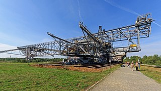
South view of the overburden conveyor bridge F60 (2015)

The visitor mine from the air.
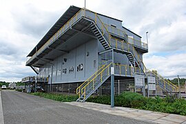
Visitor center of the visitor mine overburden conveyor bridge F60.

Max Raabe concert at the F 60 (2008)


_01.JPG)
Web links
Notes and individual references
- ↑ Community and district directory. In: geobasis-bb.de. Land surveying and geographic base information Brandenburg, accessed on August 21, 2017 .
- ↑ a b Reinhard E. Fischer : The place names of the states of Brandenburg and Berlin . be.bra Wissenschaft, Berlin 2005, ISBN 978-3-937233-30-7 , p. 92 .
- ^ A b c d e Author collective of the MUG Brandenburg eV: Heimatbuch Landkreis Elbe-Elster . Herzberg 1996, p. 90 .
- ↑ August Schumann : Complete State, Post and Newspaper Lexicon of Saxony . tape 14 . Zwickau 1827.
- ↑ a b c d Association of friends for the promotion of the local writing "Finsterwalder Heimatkalender" (Ed.): The pitch huts in the region around Finsterwalde . 2008, p. 18 (special issue on the Finsterwalder home calendar).
- ↑ a b c d e f Manfred Woitzik: “First come - first served”, a cultural history of the mills in the Elbe-Elster district . Ed .: Cultural Office of the Elbe-Elster District. Herzberg 2000, p. 167-168 .
- ↑ a b Matthias Baxmann: "Overburden conveyor bridge F 60" visitor mine - bridge from the past to the future . In: Kulturamt des Landkreis Elbe-Elster (Hrsg.): Coal, wind and water. An energy historical foray through the Elbe-Elsterland . Herzberg / Elster 2001, ISBN 3-00-008956-X , p. 72-88 .
- ↑ a b c Author collective: Mining history in the Lauchhammer district . Ed .: Traditionsverein Braunkohle Lauchhammer eV Lauchhammer 2003, p. 102-104 .
- ↑ a b The Klettwitz opencast mine in the online project www.ostkohle.de , accessed on August 19, 2017
- ↑ Project 2: Visitor mine F60 “Lying Eiffel Tower in Lusatia” , at www.iba-see2010.de, accessed on August 20, 2017
- ↑ Flooding level Brandenburg Lusatia - LMBV. lmbv.de, accessed on August 20, 2017 .
- ^ Amt Kleine Elster (Niederlausitz)> Municipalities - Lichterfeld-Schacksdorf on the website of the Amt Kleine Elster
- ↑ Worldwide projects> Lusatian lighthouses - Lusatia as a garden on the website of the German Pavilion for Expo 2000
- ^ Historical municipality register 2005 for Brandenburg statistik.brandenburg.de (PDF)
- ^ A b Service portal of the state administration - community of Lichterfeld-Schacksdorf
- ↑ As of August 20, 2017
- ↑ The mayor in the Kleine Elster office on the Kleine Elster office homepage, accessed on August 20, 2017
- ↑ Merger of the communities of Lichterfeld and Schacksdorf (Kleine Elster (Niederlausitz)) to form a new community of Lichterfeld-Schacksdorf. Announcement of the Ministry of the Interior of December 18, 1997. Official Gazette for Brandenburg Common Ministerial Gazette for the State of Brandenburg, Volume 9, Number 2, January 22, 1998, p. 24.
- ↑ Historical municipality register of the state of Brandenburg 1875 to 2005. Elbe-Elster district . P. 35
- ↑ a b Database of the Brandenburg State Office for the Preservation of Monuments and the State Archaeological Museum ( Memento of the original from December 9, 2017 in the Internet Archive ) Info: The archive link has been inserted automatically and has not yet been checked. Please check the original and archive link according to the instructions and then remove this notice. , accessed on August 13, 2017.
- ↑ Events> Shows / Concerts on the website of the visitor mine F60, accessed on August 19, 2017