
District of Prignitz
| coat of arms | Germany map |
|---|---|

|

Coordinates: 53 ° 7 ' N , 11 ° 58' E |
| Basic data | |
| State : | Brandenburg |
| Administrative headquarters : | Pearl Mountain |
| Area : | 2,138.61 km 2 |
| Residents: | 76,158 (Dec. 31, 2019) |
| Population density : | 36 inhabitants per km 2 |
| License plate : | PR |
| Circle key : | 12 0 70 |
| NUTS : | DE417 |
| Circle structure: | 26 municipalities |
| Address of the district administration: |
Berliner Strasse 49 19348 Perleberg |
| Website : | |
| District Administrator : | Torsten Uhe (independent) |
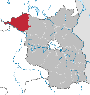
| Location of the Prignitz district in Brandenburg | |
  |
|
The district of Prignitz is a district in the extreme northwest of the state of Brandenburg. It is named after the historic Prignitz landscape .
geography
Due to its isolated location within Brandenburg , the Prignitz district is unique in several ways. Over half of its district border is also the outer border of the state of Brandenburg. It borders on just one other Brandenburg district, but on three other states: Mecklenburg-Western Pomerania, Lower Saxony and Saxony-Anhalt.
Neighboring districts are the Mecklenburg-Western Pomerania district of Ludwigslust-Parchim in the north, the Brandenburg district of Ostprignitz-Ruppin in the east, the Saxony-Anhalt district of Stendal in the south and the Lower Saxony district of Lüchow-Dannenberg in the west .
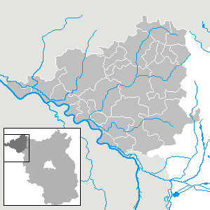
Communities
After the municipal reform has been completed, the district will comprise 26 municipalities, including seven cities. Population as of December 31, 2019.
Unofficial cities
- Perleberg (12,065)
- Pritzwalk (11,879)
- Wittenberg (16,925)
Other municipalities not subject to official duties
- Gross Pankow (Prignitz) (3789)
- Gumtow (3327)
- Karstädt (5967)
- Plattenburg (3274)
Offices and associated communities

(Seat of the official administration *)
Bad Wilsnack / Weisen (6061)
- Bad Wilsnack , City * (2533)
- Breese (1504)
- Legde / Quitzöbel (601)
- Rühstädt (456)
- Sages (967)
Lenzen-Elbtalaue (3970)
- Cumlose (727)
- Lanz (717)
- Lenzen (Elbe) , city * (2071)
- Lenten wipes (455)
Meyenburg (4106)
- Gerdshagen (502)
- Halenbeck-Rohlsdorf (486)
- Kümmernitztal (356)
- Marienfließ (697)
- Meyenburg , City * (2065)
Putlitz Mountains (4795)
- Mountains (754)
- Gülitz-Reetz (456)
- Pirov (424)
- Putlitz , town * (2664)
- Triglitz (497)
history
The district of Prignitz was formed in the course of the Brandenburg district reform on December 6, 1993 by the merger of the former districts of Pritzwalk (with the exception of the former communities of Blumenthal , Grabow and Rosenwinkel , which were incorporated into the district of Ostprignitz-Ruppin) and Perleberg (including the communities of today's Office Lenzen-Elbtalaue , which until July 31, 1992 belonged to the Ludwigslust district in Mecklenburg-Western Pomerania, with the exception of the Cumlosen community, which previously belonged to the Perleberg district) and the communities of Barenthin , Dannenwalde , Demerthin , Döllen , Granzow , Gumtow , Kolrep , Kunow , Schrepkow , Vehlin , Vehlow and Wutike of the Gumtow office of the former Kyritz district. The name and seat of the district was determined by the Prignitz Act of April 22, 1993.
From 1818 to 1952, today's district was part of the Ostprignitz district and the Westprignitz district with its headquarters in the district towns of Kyritz and Perleberg .
Population development
With 36 inhabitants per km² (2015), the district of Prignitz has the lowest population density of all districts in the Federal Republic of Germany. The following overview shows the population development in the Prignitz district from 1993.

|
|
|
Territory and number of inhabitants on December 31 of the respective year, from 2011 based on the 2011 census
politics
District council
Since the election on May 26, 2019, the 46 seats in the district council have been distributed among parties and groups of voters as follows:
| Party / group | Voices 2014 | Voices 2019 | Seats 2014 | Seats 2019 | |
|---|---|---|---|---|---|
| SPD | 23.8% | 19.1% | 11 | 9 | |
| CDU | 25.2% | 19.0% | 12 | 9 | |
| AfD | 1.0% | 13.3% | 1 | 6th | |
| The left | 18.1% | 12.5% | 8th | 6th | |
| farmers | 13.8% | 11.2% | 6th | 5 | |
| BVB / Free Voters | 6.2% | 10.5% | 3 | 5 | |
| B90 / greens | 4.9% | 7.4% | 2 | 3 | |
| FDP | 6.9% | 6.6% | 3 | 3 |
District Administrator
- 1993–2014: Hans Lange (CDU)
- since 2014: Torsten Uhe (independent)
The first direct election of a district administrator in the Prignitz district took place on May 11, 2014. Torsten Uhe, who was set up by the SPD and supported by Die Linke, prevailed against his competitors in the first ballot with 64.1% of the valid votes - a novelty in the state of Brandenburg until then. He was elected for a term of eight years in accordance with § 126 of the municipal constitution of the state of Brandenburg.
coat of arms
The coat of arms was approved on March 14, 1994.
Blazon : “Divided in red over silver by a wave cut; above a gold-armored, ready-to-fly silver goose accompanied by eight silver pearls forming an open semicircle, below a red-tongued, striding black wolf. "
Meaning : “The shield division red over silver shows the colors of the state of Brandenburg. The wave cut points to the location on the Elbe . The goose, ready to fly, is reminiscent of the family of the Goose Noble Lords of Putlitz , who, together with the Bishop of Havelberg in the Prignitz, introduced Christianity and German culture and carried out rural colonization in the 12th century . Its symbol appears again in the coat of arms of the city of Putlitz and used to stand for Wittenberge . The pearl wreath stands for the district town of Perleberg , the wolf for the previous district town of Pritzwalk . "
The coats of arms of the offices, cities and municipalities of the district can be found in the list of coats of arms in the district of Prignitz .
flag
The flag is striped black and white (1: 1) and has the circular coat of arms in the center.
Economy and Infrastructure
economy
In the Future Atlas 2016 , the Prignitz district was ranked 399 out of 402 districts, municipal associations and independent cities in Germany, making it one of the regions with “very high future risks”. The district was one of the structurally weakest areas in the country.
The economic character of the region is shaped by agricultural production and processing, small and medium-sized industry, handicrafts and trades in a wide variety of areas as well as a broad service sector.
The regional growth core Perleberg-Wittenberge-Karstädt and the region around Pritzwalk / Falkenhagen are to be considered as regional focal points of economic development .
A total of eleven fully developed industrial areas for the commercial sector are identified in the Prignitz district.
traffic
The district of Prignitz has a connection to the federal highways A 24 and A 14 as well as the federal highways B 189 and B 5 , which intersect in Perleberg , the federal highways B 103 and B 107 , which intersect in Pritzwalk , as well as the B 195 and the B 321 .
The bus traffic in the entire district is carried out by ARGE Prignitzbus . The bus network is structured hierarchically, many villages in the district are served by call buses several times a day . The main bus axes are used in regular intervals. The rail traffic is provided by the Deutsche Bahn AG , the East German Railway and the Hanseatic Railway , the node for all lines is the Wittenberge station . A uniform tariff applies to buses and trains ( Verkehrsverbund Berlin-Brandenburg ).
Until around 1970, the two predecessor districts were opened up by an extensive network of normal and narrow-gauge lines of the small railways in the Ost- and Westprignitz districts .
Protected areas
There are 35 designated nature reserves in the district (as of February 2017).
License Plate
On January 1, 1994, the district was assigned the distinctive sign PR and has been issued ever since.
Until about the year 2000 vehicles from the old districts received special identification numbers:
| area | Letters | numbers |
|---|---|---|
| Perleberg old district | A to S | 1 to 999 |
| AA to SZ | ||
| Old district Pritzwalk | T to Z | |
| TA to ZZ |
Incorporation and amalgamation of municipalities
The table shows the incorporations and mergers of municipalities since the district was formed on December 5, 1993.
Others
In the district area, East Low German Platt is occasionally spoken.
The old Polish name Przegnica , or its original form Pregynica , which could be translated as “impassable forest area” or “difficult to pass area”, comes from the Slavic Lutizen , Drevanen and Hevellern and dates back to before 1100.
literature
- Alfred Götze : The prehistoric and early historical monuments of the Ostprignitz district . In: The Art Monuments of the Prov. Brandenburg . The prehistoric and early historical monuments. Berlin 1907, 68 pp., 2 plates, 37 illustrations in the text
- Alfred Götze: The prehistoric and early historical monuments of the Westprignitz district . In: The art monuments of the province of Brandenburg . Berlin 1912, 68 pages, 2 plates, 79 illustrations in the text
- A. Rinck, H. Engel, R. Gädcke: Pictures from the history of Prignitz, [Older Stone Age, castle walls, Germanization, foundation, the cities, Christianization, the nobility, etc. a., each with ill. ]. Wittenberge (District Potsdam) 1925
- Walther Matthes : Prehistory of the Ostprignitz district . (published by the district committee of the Ostprignitz district). Curt Kabitzsch, Leipzig 1929
- Walther Matthes: The Teutons in the Prignitz at the time of the Migration Period - In the mirror of the urn fields of Dahlhausen, Kuhbier and Kyritz. Curt Kabitzsch, Leipzig 1931
- Hans Joachim Bodenbach: Publications by Prof. Dr. sc. phil. Horst Keiling, Schwerin (bibliography). In: Werner Budesheim (Ed.): Searching, collecting, sifting - for research on prehistory and early history in Northern Germany . Festschrift for Horst Keiling (Articles for Science and Culture, Volume 11). Free Lauenburg Academy for Science and Culture, Wentorf near Hamburg 2014, pp. 162–197 [also with numerous sites on the Prignitz]
Web links
- Official website of the Prignitz district
Individual evidence
- ↑ Population in the State of Brandenburg according to municipalities, offices and municipalities not subject to official registration on December 31, 2019 (XLSX file; 223 KB) (updated official population figures) ( help on this ).
- ↑ Population in the State of Brandenburg according to municipalities, offices and municipalities not subject to official registration on December 31, 2019 (XLSX file; 223 KB) (updated official population figures) ( help on this ).
- ↑ Law to determine the administrative seat and name of the Prignitz district (Prignitz Law - PrG) of April 22, 1993. Law and Ordinance Gazette for the State of Brandenburg, Part 1, No. 8 of April 28, 1993. P. 142.
- ↑ Historical municipality register of the state of Brandenburg 1875 to 2005. Prignitz district . Pp. 8-9
- ↑ Population in the state of Brandenburg from 1991 to 2015 according to independent cities, districts and municipalities , Table 7
- ^ Office for Statistics Berlin-Brandenburg (Ed.): Statistical report AI 1, A II 4. Population development and population status in the state of Brandenburg. (respective editions of the 4th quarter)
- ↑ Local elections in the state of Brandenburg on May 26, 2019 , p. 22
- ↑ District Administrator of Prignitz gives up his office. Hans Lange wants to take early retirement. In: maz-online.de. December 5, 2013, accessed June 15, 2014 .
- ^ Result of the district election on May 11, 2014 ( Memento from July 4, 2016 in the Internet Archive )
- ↑ Torsten Uhe is the new district administrator in Prignitz. Clear victory for non-party SPD candidates. In: maz-online.de. May 11, 2014, accessed June 15, 2014 .
- ↑ Coat of arms information on the service portal of the state administration of Brandenburg
- ↑ Coat of arms of the Prignitz district, Prignitz district
- ↑ Main statutes of the Prignitz district . (PDF; 98 kB) As of December 10, 2015, accessed on September 9, 2017.
- ↑ Future Atlas 2016. (No longer available online.) Archived from the original on October 2, 2017 ; accessed on March 23, 2018 .
- ↑ Timetables for bus traffic in the Prignitz district
- ^ Historical municipality register of the state of Brandenburg 1875 to 2005. Prignitz district , pp. 34–37.

Counties: Barnim | Dahme-Spreewald | Elbe Elster | Havelland | Märkisch-Oderland | Oberhavel | Oberspreewald-Lausitz | Oder-Spree | Ostprignitz-Ruppin | Potsdam-Mittelmark | Prignitz | Spree-Neisse | Teltow-Fläming | Uckermark
Independent cities: Brandenburg an der Havel | Cottbus | Frankfurt (Oder) | Potsdam