
Lanz (Prignitz)
| coat of arms | Germany map | |
|---|---|---|

|
Coordinates: 53 ° 5 ' N , 11 ° 36' E |
|
| Basic data | ||
| State : | Brandenburg | |
| County : | Prignitz | |
| Office : | Lenzen-Elbtalaue | |
| Height : | 22 m above sea level NHN | |
| Area : | 60.36 km 2 | |
| Residents: | 717 (Dec. 31, 2019) | |
| Population density : | 12 inhabitants per km 2 | |
| Postal code : | 19309 | |
| Area code : | 038780 | |
| License plate : | PR | |
| Community key : | 12 0 70 236 | |
| Community structure: | 7 parts of the community | |
| Address of the municipal administration: |
19309 Lanz | |
| Mayor : | Hans Borchert ( CDU ) | |
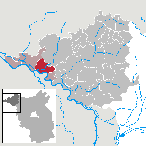
| Location of the municipality of Lanz in the Prignitz district | ||
  |
||

Lanz is a municipality in the Prignitz district in Brandenburg .
geography
Lanz is a Brandenburg municipality in the southwest of the Prignitz . The community belongs to the Lenzen-Elbtalaue office. The administrative seat of the office is the city of Lenzen . Closest cities are Lenzen in the west and Wittenberge in the southeast. Together with its parts of the community, the local area extends from Lanz in the south to the Elbe and is traversed by the Löcknitz .
Community structure
Babekuhl , Bernheide , Ferbitz , Gadow , Jagel , Lütkenwisch and Wustrow are listed as inhabited parts of the community . The Bärwinkel and Mittelhorst residential areas also belong to Lanz.
history
From many archaeological finds it can be concluded that there was a settlement in the Stone Age . Lanz, a typical round village in its local area, was first mentioned in 1325 as Lantzig.
The municipality of Wustrow is first mentioned in 1399 as Wusterowe, Ferbitz, also a round village, in 1423 as Verbettze, Jagel in 1423 as Jauel and Bernheide in 1521 as Berneheide. The Gadow part of the municipality was probably desolate in the Middle Ages and is later handed down exclusively as a manor . There is evidence of a medieval settlement for the Lütkenwisch part of the municipality, which is located directly on the Elbe dike.
In May 1945 the Red Army reached the Elbe from the east. The villages were then on the demarcation line to the British occupation zone , after the establishment of the GDR in the border and restricted area to the FRG. To intimidate the predominantly rural population, forced evacuations took place (1952 " Aktion Ungeziefer ", 1961 " Aktion Kornblume "). The GDR had families that were considered politically unreliable forcibly resettled from the inner-German border to the interior of the country. The assessment of “political unreliability” was arbitrary, so that above all people were recorded who had made any negative comments about the state. Primarily farming families were evacuated and their businesses expropriated with the aim of promoting the development of the socialist agricultural production cooperatives.
The town of Lütkenwisch, located in the 500-meter protective strip, lost 85% of its population as a result of reprisals from the GDR border regime by the fall of 1989, and more than 40 buildings were demolished. For 1992 it was planned to grind the place to the ground.
Lanz belonged to the Westprignitz district in the province of Brandenburg since 1817 and to the Ludwigslust district in the GDR district of Schwerin from 1952 . Lanz has been in the Brandenburg district of Prignitz since 1993.
Population development
|
|
|
|
|
Territory of the respective year, number of inhabitants: as of December 31 (from 1991), from 2011 based on the 2011 census
politics
Community representation
The community council of Lanz consists of 10 community representatives and the honorary mayor. The local election on May 26, 2019 resulted in the following distribution of seats:
| Party / group of voters | Seats |
|---|---|
| CDU | 4th |
| We from here | 4th |
| Single applicant Mirko Fechter | 1 |
| FDP | 1 |
mayor
- since 1998: Hans Borchert (CDU)
Borchert was elected in the mayoral election on June 16, 2019 with 53.4% of the valid votes for a further term of five years.
Sights and culture

In the list of architectural monuments in Lanz (Prignitz) are the monuments entered in the list of monuments of the state of Brandenburg.
Buildings
- Field stone church Lanz with a boarded tower
- Birthplace of Friedrich Ludwig Jahn
- Gadow Castle
- Ice cellar Gadow
Museums
- Friedrich Ludwig Jahn memorial
Parks
The Schlosspark Gadow with its dendrologically valuable population is worth seeing . In addition to other natural monuments there is the oldest oak in the Prignitz district.
Regular events
- Rhododendron Festival Gadow
Economy and Infrastructure
traffic
Lanz is located on the federal highway 195 between Lenzen and Wittenberge . From Lütkenwisch on the national road L 121 there is a ferry connection over the Elbe to Schnackenburg .
The section between Wittenberge and Dömitz of the Wittenberge – Buchholz railway line , on which the Lanz train station was located, was dismantled in 1947 as a reparation payment to the Soviet Union .
education
There is a day-care center and the Friedrich-Ludwig-Jahn primary school in Lanz.
Personalities

- Friedrich Ludwig Jahn (1778–1852), gymnastics father , born in Lanz
- Horst Behrendt (1910–1975), lieutenant colonel and party secretary in the Ministry for State Security
literature
- Historical Gazetteer Brandenburg - Part 1 - Prignitz - A-M . Modifications made by Lieselott Enders . In: Klaus Neitmann (Ed.): Publications of the Brandenburgisches Landeshauptarchiv (State Archive Potsdam) - Volume 3 . Founded by Friedrich Beck . Publishing house Klaus-D. Becker, Potsdam 2012, ISBN 978-3-88372-032-6 , pp. 483 ff .
Web links
- Office Lenzen-Elbtalaue
- Wustrow in the RBB program Landschleicher on October 2, 2005
Individual evidence
- ↑ Population in the State of Brandenburg according to municipalities, offices and municipalities not subject to official registration on December 31, 2019 (XLSX file; 223 KB) (updated official population figures) ( help on this ).
- ↑ Lanz community. Ministry of the Interior of Brandenburg, accessed on February 8, 2016 .
- ↑ www.bldam.brandenburg.de
- ↑ Historical municipality register of the state of Brandenburg 1875 to 2005. Prignitz district . Pp. 22-25
- ↑ Population in the state of Brandenburg from 1991 to 2017 according to independent cities, districts and municipalities , Table 7
- ^ Office for Statistics Berlin-Brandenburg (Ed.): Statistical report AI 7, A II 3, A III 3. Population development and population status in the state of Brandenburg (respective editions of the month of December)
- ^ Result of the local election on May 26, 2019
- ↑ Results of the local elections in 1998 (mayoral elections) for the Prignitz district ( Memento from April 14, 2018 in the Internet Archive )
- ↑ Brandenburg Local Election Act, Section 73 (1)
- ^ Result of the mayoral election on June 16, 2019
- ↑ Ordinance of the Prignitz district on natural monuments in the Lenzen-Elbtalaue district (PDF; 18 kB) , landkreis-prignitz.de, September 21, 2010, accessed on March 11, 2013, p. 3
- ↑ School portraits - Friedrich-Ludwig-Jahn-Grundschule Lanz. In: Bildungsserver Berlin-Brandenburg. State Institute for School and Media Berlin-Brandenburg (LISUM), accessed on January 3, 2016 .
Bad Wilsnack | Mountains | Breese | Cumlosen | Gerdshagen | Groß Pankow (Prignitz) | Gülitz-Reetz | Gumtow | Halenbeck-Rohlsdorf | Karstädt | Kümmernitztal | Lanz | Legde / Quitzöbel | Lenzen (Elbe) | Lenten wipes | Marienfließ | Meyenburg | Perleberg | Pirov | Plattenburg | Pritzwalk | Putlitz | Rühstädt | Triglitz | Wise men | Wittenberg