Boberow (Karstädt)
|
Boberow
Karstädt municipality
Coordinates: 53 ° 8 ′ 40 ″ N , 11 ° 36 ′ 57 ″ E
|
|
|---|---|
| Height : | 37 m above sea level NHN |
| Incorporation : | October 26, 2003 |
| Postal code : | 19357 |
| Area code : | 038781 |
|
Eastern entrance to the village
|
|
Boberow is a district of the municipality of Karstädt in the Prignitz district in Brandenburg .
geography
The place is nine kilometers west of Karstädt and ten kilometers northeast of Lenzen (Elbe) . The neighboring towns are Seetz and Gosedahl in the northeast, Mankmuß and Birkholz in the southeast, Ferbitz and Nausdorf in the southwest and Rambow and Mellen in the northwest.
The Rambower See is located in the Boberow district , part of the Rambower Moor flow-through moor .
history
The first written mention of Boberow comes from the year 1309. Therein the place was recorded under "uterque Boberowe".
According to an entry in Volume 2, Column 215 ff. Of the "Historical Description of Chur and Mark Brandenburg" by Beckmann from 1753, a "Wendish churchyard" was mentioned near Boberow in the 18th century. Before 1816 the place belonged to the district of Lenzen in the province of Prignitz ; part of the Kurmark of the Mark Brandenburg and then came to the Westprignitz district . On the original table sheet "1388 Rambow" from 1843 Boberow is recorded as a street village with a church. In 1860 the parish had a total size of 4632 acres. Of these, 60 acres each were homesteads and garden land, 119 acres of pasture, 218 acres of meadows, 1,838 acres of forest and, with the largest proportion, 2,337 acres of arable land. In 1900 the municipality consisted of the village with a mill and had a district size of 1274 hectares. The district became the municipality of Boberow in 1931 and covered an area of 1354 hectares. In 1939 the previously independent community of Gosedahl was incorporated into Boberow.
From 1952 Boberow belonged to the Perleberg district in the Schwerin district . In 1964 the neighboring Gosedahl was registered as a district. In 1992 the municipality of Boberow joined the newly formed Karstädt Office and in 1993 became part of what is now the Prignitz district. In 1995 Gosedahl was still listed as a district of the municipality.
The previously independent municipality of Boberow was incorporated into Karstädt on October 26, 2003.
- Population development
| year | 1734 | 1772 | 1791 | 1801 | 1817 | 1837 | 1858 | 1871 | 1895 | 1925 | 1939 | 1946 | 1964 | 1971 | 1981 | 1991 |
|---|---|---|---|---|---|---|---|---|---|---|---|---|---|---|---|---|
| population | 179 | 211 | 276 | 283 | 253 | 346 | 484 | 500 | 435 | 391 | 365 | 615 | 401 | 376 | 298 | 298 |
| source |
Attractions
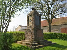
The list of architectural monuments in Karstädt contains a total of three entries about the place: the village church, the war memorial and the Dorfstrasse 33 farm. The three large stone graves near Boberow , which were destroyed between the 17th and 19th centuries, can no longer be found. The list of soil monuments in Karstädt includes a total of 12 soil monuments for the Boberow district.
Born in the place
- Friedrich Gedike (1754–1803), German theologian and educator
literature
- Historical Gazetteer Brandenburg - Part 1 - Prignitz - A-M . Modifications made by Lieselott Enders . In: Klaus Neitmann (Ed.): Publications of the Brandenburgisches Landeshauptarchiv (State Archive Potsdam) - Volume 3 . Founded by Friedrich Beck . Publishing house Klaus-D. Becker, Potsdam 2012, ISBN 978-3-88372-032-6 , pp. 70 ff .
Web links
- Boberow in the historical directory of the association for computer genealogy
- Boberow in the rbb series "Der Landschleicher"
- Boberow on gemeinde-karstaedt.de
Individual evidence
- ↑ Karstädt municipality - districts according to § 45 municipal constitution - inhabited parts of the municipality - living spaces. In: service.brandenburg.de. Ministry of the Interior and Local Affairs of the State of Brandenburg, accessed on July 20, 2018 .
- ↑ a b BrandenburgViewer of the state survey and geographic base information Brandenburg (LGB)
- ↑ a b c Neitmann (Ed.): Historical local dictionary for Brandenburg - Part 1 - Prignitz - A – M. 2012, p. 70.
- ↑ State Office for Data Processing and Statistics State of Brandenburg (Ed.): Contribution to statistics - Historical municipality register of the State of Brandenburg 1875 to 2005 - Prignitz district . tape 19.12 . Potsdam 2006, p. 35 ( statistik-berlin-brandenburg.de [PDF; 397 kB ; accessed on July 20, 2018]).
- ^ Neitmann (ed.): Historical local dictionary for Brandenburg - Part 1 - Prignitz - A – M. 2012, p. 73.


