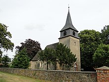
Reckenzin
|
Reckenzin
Karstädt municipality
Coordinates: 53 ° 13 ′ 28 ″ N , 11 ° 41 ′ 44 ″ E
|
|
|---|---|
| Height : | 34 m above sea level NHN |
| Incorporation : | December 31, 2001 |
| Postal code : | 19357 |
| Area code : | 038788 |
Reckenzin is a district of the municipality of Karstädt in the Prignitz district in Brandenburg .
geography
The place is 8 kilometers north-northwest of Karstädt and 19 kilometers northwest of Perleberg . The neighboring towns are Balow and Dambeck in the northeast, Streesow in the east, Dallmin in the southeast, Bootz in the south, brickworks in the southwest, Kolonie in the west and Klein Warnow and Wendisch Warnow in the northwest.
history
The first written mention of Reckenzin comes from the year 1378. Therein the place was recorded under "Rekentzin".
Before 1816 the place belonged to the district of Lenzen in the province of Prignitz ; part of the Kurmark of the Mark Brandenburg and then came to the Westprignitz district . On the original table sheet "1308 Balow" from 1825, Reckenzin can be recognized as a large village on which the church stands. At that time, parts of the desert Lehmkuhl field were probably already included. 1860, the place has a municipal area size of a total of 3188 morning. Of these, 45 acres were gardens, 70 acres of farms, 355 acres of forest, 460 acres of meadow, 706 acres of pasture and 1,552 acres of fields. In 1877 the desert Feldmark Lehmkuhl was divided into plots and divided between the communities of Reckenzin and Sargleben. In 1900 the village was a municipality and covered an area of 834 hectares.
In 1931 Reckenzin was listed as a municipality to which the "New Pinnow extension" residential area belonged and a total of 835 hectares belonged. From 1952 Reckenzin belonged to the Perleberg district in the Schwerin district . In 1957 the residential area "Expansion New Pinnow" was again registered as part of the municipality, but was no longer mentioned in 1964. In 1973 the previously independent municipality of Streesow was incorporated. In 1985 Streesow was run as a district of the community. In 1992 the municipality of Reckenzin joined the newly formed Karstädt Office and in 1993 became part of what is now the Prignitz district. In 1995 Streesow was again listed as a district.
The previously independent municipality of Reckenzin was incorporated into Karstädt on December 31, 2001.
Culture and sights
In addition to the Reckenzin village church, the list of architectural monuments in Karstädt contains two other entries on the site.
The list of soil monuments in Karstädt includes a total of ten soil monuments for the Reckenzin district.
In Reckenzin, Faslam , a rural Low German winter custom, is not practiced around the winter solstice, but at Whitsun as Ausmaien or egg scorching.
traffic
The place can be reached via two state roads of the second order: via the L 133 from Dallmin and Garlin and via the L 134 from Groß Warnow . The closest junction of the new federal motorway 14 is also located at the latter location .
The Berlin – Hamburg railway divides the place and separates the western parts of the settlement from the main town. There is no train station here.
literature
- Historical Gazetteer Brandenburg - Part 1 - Prignitz - N-Z . Modifications made by Lieselott Enders . In: Klaus Neitmann (Ed.): Publications of the Brandenburgisches Landeshauptarchiv (State Archive Potsdam) - Volume 3 . Founded by Friedrich Beck . Publishing house Klaus-D. Becker, Potsdam 2012, ISBN 978-3-88372-033-3 , pp. 725 ff .
Web links
- Reckenzin in the historical directory of the association for computer genealogy
- Reckenzin in the rbb series "Der Landschleicher"
- Reckenzin on gemeinde-karstaedt.de
Individual evidence
- ↑ Karstädt municipality - districts according to § 45 municipal constitution - inhabited parts of the municipality - living spaces. In: service.brandenburg.de. Ministry of the Interior and Local Affairs of the State of Brandenburg, accessed on July 20, 2018 .
- ↑ a b c BrandenburgViewer of the state survey and geographic base information Brandenburg (LGB)
- ↑ a b c Neitmann (ed.): Historical local dictionary for Brandenburg - Part 1 - Prignitz - N – Z. 2012, p. 725.
- ↑ State Office for Data Processing and Statistics State of Brandenburg (Ed.): Contribution to statistics - Historical municipality register of the State of Brandenburg 1875 to 2005 - Prignitz district . tape 19.12 . Potsdam 2006, p. 35 ( statistik-berlin-brandenburg.de [PDF; 397 kB ; accessed on July 20, 2018]).

