
Jüterbog district
| Basic data (as of 1993) | |
|---|---|
| Existing period: | 1952-1993 |
| District : | Potsdam |
| Administrative headquarters : | Jueterbog |
| Area : | 766 km² |
| Residents: | 35,951 (1989) |
| Population density: | 47 inhabitants per km² |
| License plate : | D and P (1953–1990) DF (1974–1990) JB (1991–1993) |
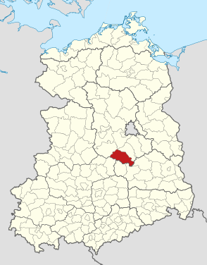
| Location of the district in the GDR | |
  |
|
The Jüterbog district was a district in the Potsdam district of the GDR . From 1990 to 1993 it existed as the Jüterbog district in the state of Brandenburg . His area is now in the districts of Teltow-Fläming and Potsdam-Mittelmark in Brandenburg. The seat of the district administration was in Jüterbog .
geography
Location and greatest places
The Jüterbog district comprised a large part of the Fläming region . The largest towns in the district besides the district town of Jüterbog were the town of Treuenbrietzen and the communities of Altes Lager , Bardenitz , Blönsdorf , Hohenseefeld, Zinna Monastery , Malterhausen , Marzahna , Niedergörsdorf and Oehna .
Neighboring areas
The Jüterbog district bordered clockwise in the northwest, beginning with the Belzig and Luckenwalde districts ( Potsdam district ), Luckau , Herzberg and Jessen ( Cottbus district ) and Wittenberg ( Halle district ).
history
On 25th 1952 there was a comprehensive administrative reform in the GDR , during which, among other things, the states lost their importance and new districts were formed. The new Jüterbog district with its headquarters in Jüterbog was formed from parts of the former districts of Herzberg , Luckenwalde , Wittenberg and Zauch-Belzig . The district was assigned to the new district of Potsdam .
On May 17, 1990 the district was renamed the Jüterbog district. On the occasion of the reunification of the two German states, the Jüterbog district was awarded to the re-established state of Brandenburg .
District municipalities and cities
All places are listed that were independent municipalities on July 25, 1952 when the Jüterbog district was established. Communities that lost their independence by December 5, 1993 and were integrated into larger neighboring communities have moved in.
- Old warehouse
-
Bardenitz
- Bärwalde (was incorporated into Meinsdorf on January 1, 1979)
- Blönsdorf
- Bochow
- Borgisdorf
- Danna
- Dennewitz
-
Feldheim
- Gölsdorf (was incorporated into Niedergörsdorf on January 1, 1957)
- Graefendorf
- Grüna
-
Herbersdorf
- Höfgen (was incorporated into Welsickendorf on January 11, 1962)
- Hohenahlsdorf
- Hohengörsdorf
- Hohenseefeld
- Ihlow
- Illmersdorf
-
Jueterbog
- Kaltenborn (was incorporated into Niedergörsdorf on January 1, 1957)
- Klausdorf (was incorporated into Bardenitz on January 1, 1974)
- Zinna Monastery
-
Langenlipsdorf
- Lichterfelde (was incorporated into Werbig on January 11, 1962)
- Lindow (was incorporated into Malterhausen on January 11, 1962)
-
Lobbies
- Lüdendorf (was incorporated into Treuenbrietzen on January 1, 1974)
- Malterhausen
- Brandendorf
- Marzahna
- Meinsdorf
- Neuheim
- Neuhof
- Niedergörsdorf
- Nun village
- Oehna
- Reinsdorf
- Riesdorf
-
Rietz
- Rinow (was incorporated into Meinsdorf on January 11, 1962)
- Rohrbeck
- Fluff
- Schönefeld
- Seehausen
- Sernow
- Treuenbrietzen
-
Waltersdorf
- Weißen (was incorporated into Meinsdorf on January 11, 1962)
- Welsickendorf
- Advertising
- Werder
- Wergzahna
-
Wiepersdorf
- Wölmsdorf (was incorporated into Niedergörsdorf on January 1, 1957)
-
Zellendorf
- Zeuden (was incorporated on January 1, 1974 after Lobbese)
In the course of the municipal reform in Brandenburg in 1992, the following offices were formed in the district area (partly across districts): Office Dahme / Mark , Office Jüterbog , Office Niederer Fläming , Office Niedergörsdorf and the Office Treuenbrietzen . As part of the district reform in Brandenburg , the district was dissolved on December 6, 1993. The Treuenbrietzen office became part of the new Potsdam-Mittelmark district and the rest of the district became part of the new Teltow-Fläming district .
Population development
| Jüterbog district | ||||||||
|---|---|---|---|---|---|---|---|---|
| year | 1960 | 1971 | 1981 | 1989 | ||||
| Residents | 42,162 | 41,047 | 37,132 | 35,591 | ||||
economy
Significant establishments were among others
- VEB Möbel Jüterbog
- VEB food and enjoyment Jüterbog
- VEB beverage production Jüterbog
- VEB leather clothing Jüterbog
- VEB Messgerätewerk Treuenbrietzen
- VEB vehicle plant Treuenbrietzen
traffic
The national road traffic served the long-distance roads F 2 from Potsdam via Treuenbrietzen to Lutherstadt Wittenberg , the F 101 from Großbeeren via Jüterbog to Elsterwerda , the F 102 from Belzig via Jüterbog to Luckau and the F 115 from Jüterbog to Baruth.
The Jüterbog district was linked to the GDR's railway network by the Berlin – Jüterbog – Halle , Jüterbog – Potsdam , Jüterbog – Riesa and Jüterbog – Zossen routes .
License Plate
After 1952, the vehicles registered in the district were given license plates beginning with the letter D (as in the entire Potsdam district). Motor vehicles (with the exception of motorcycles) and trailers were assigned three-letter distinctive signs starting with the pair of letters DF from around 1974 to the end of 1990 . The last number plate series used for motorcycles was DV 00-01 to DV 20-00 .
At the beginning of 1991 the district received the distinctive sign JB . It was issued until the end of 1993.
Individual evidence
- ↑ a b Federal Statistical Office (ed.): Municipalities 1994 and their changes since 01.01.1948 in the new federal states . Metzler-Poeschel, Stuttgart 1995, ISBN 3-8246-0321-7 .
- ↑ Law on the self-administration of municipalities and districts in the GDR (municipal constitution) of May 17, 1990
- ^ Statistical yearbooks of the German Democratic Republic. In: DigiZeitschriften. Retrieved February 6, 2010 .
- ↑ Andreas Herzfeld: The history of the German license plate . 4th edition. German Flag Society V., Berlin 2010, ISBN 978-3-935131-11-7 , pp. 301 .
- ↑ Andreas Herzfeld: The history of the German license plate . 4th edition. German Flag Society V., Berlin 2010, ISBN 978-3-935131-11-7 , pp. 542 .