
District of Zossen
| Basic data (as of 1993) | |
|---|---|
| Existing period: | 1952-1993 |
| District : | Potsdam |
| Administrative headquarters : | Zossen |
| Area : | 766 km² |
| Residents: | 75,310 (1989) |
| Population density: | 98 inhabitants per km² |
| License plate : | D and P (1953–1990) DY and DZ (1974–1990) ZS (1991–1993) |
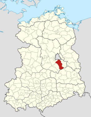
| Location of the district in the GDR | |
  |
|
The Zossen district was a district in the Potsdam district of the GDR . From 1990 to 1993 it existed as the Zossen district in the state of Brandenburg . Today, its area is largely in the Teltow-Fläming district in Brandenburg. The seat of the district administration was in Zossen .
geography
Neighboring areas
The Zossen district bordered the West Berlin districts of Steglitz and Tempelhof in the north, the Königs Wusterhausen district in the east, the Luckau district in the south and the Luckenwalde and Potsdam-Land districts in the west .
history
On July 25, 1952, there was a comprehensive administrative reform in the GDR , in which, among other things, the states lost their importance and new districts were formed. The new Zossen district with its headquarters in Zossen was formed from parts of the Luckenwalde and Teltow districts at that time . The district was assigned to the new district of Potsdam .
The headquarters of the high command of the group of Soviet armed forces in Germany was located in Wünsdorf .
On May 17, 1990, the district was renamed Landkreis. On the occasion of the reunification of the two German states, the district of Zossen was awarded to the re-established state of Brandenburg in 1990. During the district reform in Brandenburg , which came into force on December 6, 1993, it was almost completely absorbed in the new Teltow-Fläming district . Only the municipality of Telz came to the Dahme-Spreewald district .
Population development
| District of Zossen | ||||||||
|---|---|---|---|---|---|---|---|---|
| year | 1960 | 1971 | 1981 | 1989 | ||||
| Residents | 73,778 | 74,431 | 74,915 | 75,310 | ||||
economy
Significant companies were among others:
- VEB IFA automobile plant Ludwigsfelde
- VEB Funkwerk Dabendorf
- VEB Baruther Glashütte
- VEB brickworks Klausdorf
- VEB Brewery Zossen
traffic
The Zossen district was integrated into the GDR's motorway network through the Berliner Ring . The F 96 from Mahlow via Zossen to Finsterwalde , the F 101 from Großbeeren via Ludwigsfelde to Jüterbog , the F 246 from Eisenhüttenstadt via Zossen to Magdeburg and the F 115 from Baruth to Jüterbog also served national road traffic .
The Zossen district was linked to the GDR railway network via the Berlin outer ring and the Mahlow – Zossen – Dresden , Teltow – Ludwigsfelde – Halle and Zossen – Jüterbog routes .
Towns and municipalities belonging to the district
All places are listed that were independent municipalities on July 25, 1952 when the district of Zossen was established. Communities have moved in that have lost their independence by December 5, 1993 and have been incorporated into larger neighboring communities or have merged with neighboring communities (or have left the district).
The following places belonged to the district of Zossen (1952):
-
Ahrensdorf
- Alexanderdorf (1974 merger with Kummersdorf to form the municipality of Kummersdorf-Alexanderdorf)
- City of Baruth (since 1974 with the Klein Ziescht district )
- Birkholz (incorporated into Osdorf in 1973)
- Blankenfelde
-
Christinendorf
- Dabendorf (incorporated into Zossen in 1974)
- Dahlewitz
- Diedersdorf
-
Dornswalde
- Fernneuendorf (incorporated into Sperenberg in 1974)
- Gadsdorf
- Genshagen
- Glienick with Wohnplatz Advertise
- Gröben (1974 Jütchendorf, Mietgendorf and Schiaß were incorporated)
- Großbeeren with the districts of Kleinbeeren (since 1950) and Neubeeren (since 1928)
- Großbeuthen with the Kleinbeuthen district (since 1950)
- Great Kienitz
- Groß Machnow with residential areas Pramsdorf and Theresenhof
- Groß Schulzendorf
- Groß Ziescht ( incorporated into Kemlitz in 1959 )
- Horstfelde
- Horstwalde
-
Jühnsdorf
- Jütchendorf (incorporated into Gröben in 1974)
-
Kallinchen
- Kemlitz ( incorporated into Groß Ziescht in 1957 )
- Candle village
- Klasdorf with the Glashütte district (since 1950)
-
Klausdorf
- Klein Ziescht (incorporated into Baruth / Mark in 1974 )
- Klein Kienitz (incorporated into Rangsdorf in 1974)
-
Kummersdorf estate
- Kummersdorf (1974 merger with Kummersdorf to form the municipality of Kummersdorf-Alexanderdorf)
- Kummersdorf-Alexanderdorf (created in 1974 through the merger of Kummersdorf and Alexanderdorf)
- Lindenbrück with the Funkenmühle district (since 1874) (Zesch am See was incorporated in 1974)
- Löwenbruch
- City of Ludwigsfelde with the district of Struveshof
- Märkisch Wilmersdorf
- Mahlow with the Glasow district (since 1950)
-
Mellensee
- Mietgendorf (incorporated in Gröben in 1974)
- Mückendorf
-
Next Neuendorf with the districts Karolinenhof and Marienau
- Neuhof (incorporated into Wünsdorf in 1974)
- Nunsdorf
- Osdorf with the districts of Birkenhain, Birkholz (since 1928), Heinersdorf (since 1928) and Friederikenhof (since 1880)
- Paplitz
- Radeland with the district of Waldsiedlung
- Rangsdorf
-
Rehab
- Ruhlsdorf (from 1957 Potsdam-Land district )
-
Saalow
- Schiaß (incorporated into Gröben in 1974)
- Schöbendorf
- Schöneiche with the Schöneicher Plan district
- Schünow
- Siethen
- Sperenberg with the Fernneuendorf district (since 1974)
- Telz
- Thyrow
- Wietstock
-
Wünsdorf with the Neuhof district (since 1974)
- Zesch am See (incorporated into Lindenbrück in 1974)
The largest towns in the district besides the district town of Zossen were the towns of Baruth and Ludwigsfelde and the communities of Blankenfelde, Dahlewitz, Großbeeren, Klausdorf, Mahlow, Mellensee, Rangsdorf, Saalow, Sperenberg and Wünsdorf. In 1992, as part of the administrative reform in the state of Brandenburg, the following offices were created in the Zossen district (partly also across the district): Am Mellensee , Baruth / Mark , Blankenfelde-Mahlow , Ludwigsfelde-Land , Rangsdorf , Trebbin and Zossen .
Community associations
With the law on the local people's representatives and their organs in the GDR of July 12, 1973, the possibility was created for cities and municipalities to form associations of municipalities within a district. Seven community associations were established within the Zossen district:
- (Community association) Baruth (since February 22, 1973) with the city of Baruth / Mark, Dornswalde, Groß Ziescht, Horstwalde, Klasdorf, Mückendorf, Paplitz, Radeland, Schöbendorf, Glashütte, Klein Ziescht and Kemlitz
- (Association of local authorities) Großbeeren (since January 1, 1976) with Großbeeren, Genshagen, Osdorf, Diedersdorf, Jühnsdorf
- (Association of municipalities) Blankenfelde (since July 2, 1976) with Blankenfelde, Mahlow, Dahlewitz, Rangsdorf, Groß Machnow, Groß Kienitz
- (Association of municipalities) Glienick (since July 1, 1979) with Glienick, Next Neuendorf, Schünow, Horstfelde, Nunsdorf, Groß Schulzendorf, Wietstock, Märkisch Wilmersdorf, Löwenbruch
- (Association of municipalities) Sperenberg (since September 15, 1979) with Sperenberg, Rehagen, Kummersdorf-Gut, Kummersdorf-Alexanderdorf
- Community association Zossen (since November 1, 1979) with the city of Zossen, Wünsdorf, Klausdorf, Mellensee, Saalow, Kallinchen, Schöneiche and Telz
- (Association of municipalities) Siethen (since November 1st) with Siethen, Ahrensdorf, Gröben, Groß Beuthen, Kerzendorf and Thyrow
Only the city of Ludwigsfelde and the communities Christinendorf, Lindenbrück and Zesch am See did not belong to any community association.
License Plate
Motor vehicles (with the exception of motorcycles) and trailers were assigned three-letter distinctive signs starting with the letter pairs DY and DZ from around 1974 to the end of 1990 . The last number plate series used for motorcycles was DY 60-01 to DY 80-00 .
At the beginning of 1991 the district received the distinguishing mark ZS . It was issued until the end of 1993.
supporting documents
literature
- Siegfried Wietstruck: Community associations in our district. Local calendar for the Zossen district, 1982: 46–50, Zossen 1981
Individual evidence
- ↑ a b Federal Statistical Office (ed.): Municipalities 1994 and their changes since 01.01.1948 in the new federal states . Metzler-Poeschel, Stuttgart 1995, ISBN 3-8246-0321-7 .
- ↑ Law on the self-administration of municipalities and districts in the GDR (municipal constitution) of May 17, 1990
- ^ Statistical yearbooks of the German Democratic Republic. In: DigiZeitschriften. Retrieved February 6, 2010 .
- ↑ Law on the local people's representations and their organs in the GDR of July 12, 1973. Law Gazette, I, No. 32, p. 313
- ↑ Andreas Herzfeld: The history of the German license plate . 4th edition. German Flag Society V., Berlin 2010, ISBN 978-3-935131-11-7 , pp. 301 .
- ↑ Andreas Herzfeld: The history of the German license plate . 4th edition. German Flag Society V., Berlin 2010, ISBN 978-3-935131-11-7 , pp. 542 .