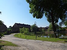
Kemlitz (Baruth / Mark)
|
Kemlitz
City of Baruth / Mark
Coordinates: 52 ° 0 ′ 38 ″ N , 13 ° 28 ′ 11 ″ E
|
||
|---|---|---|
| Height : | approx. 115 m above sea level NN | |
| Residents : | 70 (Apr 24, 2014) | |
| Incorporation : | January 1, 1957 | |
| Incorporated into: | Big Ziescht | |
| Postal code : | 15837 | |
| Area code : | 033704 | |
|
Location of Kemlitz in Brandenburg |
||
Kemlitz [ ˈkeˑmˌlɪt͡s ] is a part of the municipality of Groß Ziescht (part of the city of Baruth / Mark ) in the district of Teltow-Fläming in Brandenburg (Germany).
geography
The small village of Kemlitz is located around 50 kilometers from the southern border of the city of Berlin and around four kilometers southwest of Baruth in a gently sloping gorge of the Niedere Fläming . Neighboring villages of Kemlitz and districts of Baruth are (clockwise, starting from the northeast) Klasdorf , Groß Ziescht, Merzdorf , Schöbendorf and Paplitz . Kemlitz is located on the L712 state road between Paplitz and Görsdorf (part of the municipality of Dahmetal ), which runs in a north-south direction .
history
Kemlitz was first mentioned in 1363 as Kemenicz . The name should be of Wendish origin and mean as much as the stony place . Kemlitz belonged to the Baruther rule before 1444 , to the Kingdom of Saxony until 1815 and then to Prussia .
On January 1, 1957, Kemlitz was incorporated into Groß Ziescht. On December 31, 1997, Groß Ziescht was again incorporated into the city of Baruth together with Horstwalde, Mückendorf and Radeland .
Buildings
The Kemlitz village church is a stone church from around 1300. Inside there is a simple interior, including a horseshoe gallery from the 17th century and an altar and pulpit from the 18th century.
Web links
- An impression of Kemlitz on the website of the city of Baruth / Mark
- Kemlitz as part of the municipality of Groß Ziescht on the website of the city of Baruth / Mark
- Groß Ziescht website


