
Elmstein
| coat of arms | Germany map | |
|---|---|---|

|
Coordinates: 49 ° 21 ' N , 7 ° 56' E |
|
| Basic data | ||
| State : | Rhineland-Palatinate | |
| County : | Bad Dürkheim | |
| Association municipality : | Lambrecht (Palatinate) | |
| Height : | 225 m above sea level NHN | |
| Area : | 75.68 km 2 | |
| Residents: | 2400 (Dec. 31, 2019) | |
| Population density : | 32 inhabitants per km 2 | |
| Postal code : | 67471 | |
| Primaries : | 06328, 06306 | |
| License plate : | DÜW | |
| Community key : | 07 3 32 014 | |
| LOCODE : | DE EM3 | |
| Community structure: | 10 districts | |
| Association administration address: | Sommerbergstrasse 3 67466 Lambrecht (Palatinate) |
|
| Website : | ||
| Local Mayor : | Rene Verdaasdonk ( SPD ) | |
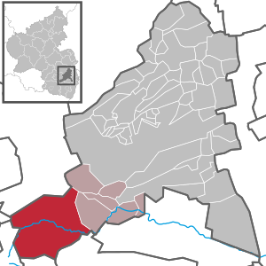
| Location of the local community Elmstein in the Bad Dürkheim district | ||
  |
||

Elmstein is the most westerly local community in the Palatinate district of Bad Dürkheim and in the Rhine-Neckar metropolitan region . It belongs to the Verbandsgemeinde Lambrecht (Palatinate) , within which it is the largest in terms of area and the second largest in terms of population. In terms of area, it is the second largest local community in the district after Bad Dürkheim .
geography
location
The local community is centrally located within the central Palatinate Forest ; the west of the district belongs to its sub-area Frankenweide , in the east lies the Elmsteiner Tal, named after the community . At 95.2%, their forest share is greater than in any other municipality in Rhineland-Palatinate .
Community structure
The municipality consists of the eponymous place Elmstein and the districts Appenthal , Erlenbach , Harzofen , Helmbach including the Oppauer settlement , Iggelbach , Mückenwiese , Röderthal , Schafhof , Schwabenbach , Schwarzbach , Stilles Tal , Speyerbrunn and Wolfsgrube .
Neighboring communities
Adjacent communities - including italics set Exklaven - are clockwise Waldleiningen , Weidenthal , Esthal , Kirrweiler (Pfalz) , Venningen , Rhodt under Rietburgbahn , Edesheim , Landau , Wilgartswiesen , Tripp city and Kaiserslautern .
The distance to the middle center Neustadt an der Weinstrasse is 25 km, to the west it is 32 km to the upper center Kaiserslautern.
Surveys
Numerous mountains of the Palatinate Forest rise up in the area around Elmstein. The 458 m high Schloßberg is located directly on the northwest slope of the core town . The Ehscheid extends northeast of Appenthal and the Grünberg to the southeast . Farther southwest away from the settlement area lies the 570 m high Bloskülb and south of it the Brogberg ( 567 m ). The 474 m high Bierenberg extends southeast of Iggelbach and further east the Große Schweinsberg ( 405.7 m ); between the core town of Elmstein and Iggelbach are the Möllberg ( 461.8 m ), the Kurz Eck and the Mönchberg .

The 571 m high Schindhübel , which also forms the highest point in the municipality, rises to the south-west of the district, and to the south-east of it is its foothill, the Blattberg ( 551 m ). The Hofberg ( 371.2 m ) stretches in the very south of the district and the Geißkopf ( 467.3 m ) and the Miedersberg ( 479.5 m ) directly on the boundary with the Landau city forest .
The Grundwieser Eck ( 407.7 m ), the Legelberg , the Scheidtaler Eck , the Legeleck , the Krottenbuckel ( 463.8 m ), the Steigberg ( 415.9 m ), the Hohe Oselkopf ( 497 , 7 m ), the Niedere Oselkopf ( 428 m ), the 516 m high Mückenberg , the 486.2 m high Weltersberg , the Hofberg ( 397.6 m ) as well as the 514 m high Riesenberg directly on the border with Waldleiningen . The Bremeneck and Erdbeerenkopf extend to the north-east .
Waters

The central flowing water is the Speyerbach , which flows through the core community and several districts such as Speyerbrunn, Mückenwiese and Appenthal. Its hydrological source river Erlenbach rises on the exclave Hofstätten belonging to Wilgartswiesen , then passes the hamlet named after him and then takes on the Schwarzbach from the left at Speyerbrunn , where the Speyerbach nominally rises in a spring pond. In the further course, the Speyerbach takes on the Enkenbach , Weltersbach , Oselbach and Legelbach from the left. At the north-western edge of the core town the Möllbach flows from the right and the Haselbach flows into the Speyerbach at its southern edge .
Further to the east, it takes its strongest inflow from the right with the Helmbach , which largely also forms the southeastern boundary of Elmstein. After its source river Teufelsbach has flowed through a forest enclave belonging to Landau, the Blattbach flows from the left , which had previously absorbed the Miedersbach from the right . Then the Grobsbach flows from the right , which forms the border to a forest enclave of Edesheim for the last 2 km of its course. 2.5 km to the east, the Helmbach takes on the Iggelbach from the left , which flows through the village of the same name. Only a short distance before its confluence with the Helmbach is the Kohlbach in the Elmstein district. The latter also includes the west bank of the Helmbachweiher, through which the Kohlbach shortly before flowed . In the east, the Breitenbach largely forms the border with Esthal; its confluence with the Speyerbach is already beyond the Elmsteiner district. Before that, it takes on the Finster-Breitenbach and the Großer Schwabenbach from the right .
geology
The so-called Elmstein Fault is geologically significant for the central Palatinate Forest .
history
A hatchet from the Neolithic Age , the so-called “Neolithic”, the flint blade of which was found in 1969 during road construction work in the Blattbachtal near Iggelbach, indicates that people lived and worked wood in the area of the local community 5000 years ago.
The main town goes back to the medieval Elmstein Castle , which was built above on the southwest slope of the Schloßberg in the 12th and 13th centuries by the Count Palatine near the Rhine and has only survived as a ruin. The districts emerged later mostly as development settlements for forest workers, as the site of a sawmill or, like Röderthal, as a mining settlement.

Until the end of the 18th century, the community, to which the neighboring Iggelbach already belonged, was part of the Electoral Palatinate . From 1798 to 1814, when the Palatinate was part of the French Republic (until 1804) and then the Napoleonic Empire , Elmstein and Iggelbach were incorporated into the canton Neustadt (Donnersberg) and at the same time the seat of a Mairie . In 1815 the place Austria was added. Just one year later, the place, like the entire Palatinate, changed to the Kingdom of Bavaria . From 1818 to 1862 the community belonged to the Landkommissariat Neustadt ; from this the district office of Neustadt emerged.
From 1939 Elmstein was part of the district of Neustadt an der Weinstrasse . After the Second World War , the municipality within the French occupation zone became part of the then newly formed state of Rhineland-Palatinate. In the course of the first administrative reform in Rhineland-Palatinate , Elmstein moved to the newly created Bad Dürkheim district in 1969 . Three years later, the community became part of the also newly created Verbandsgemeinde Lambrecht (Palatinate) . On January 1, 1976, the places Erlenbach, Schwarzbach and Speyerbrunn, which had previously belonged to Wilgartswiesen, were reassigned to Elmstein.
In 2011 Elmstein was accepted into the village renewal program as one of 20 municipalities in Rhineland-Palatinate .
population
Population development
In 1815 the community had a total of 1040 inhabitants. In the following century and a half, the number of inhabitants doubled, among other things due to the increase in the area in the west of the district, it increased again by a total of 207 inhabitants from the places Erlenbach, Schwarzbach and Speyerbrunn. Due to the peripheral location, a decline has been observed since then, around 2010 the population fell to below 2500.
religion

In 2019, 43% of the population were Protestant and 26% Catholic . The Catholics belong to the Deanery Bad Dürkheim of the Diocese of Speyer . Until the end of 2015, there was a separate parish in the core town and in Speyerbrunn, which belonged to the Neustadt parish community. Since 2016 Elmstein has been part of the Lambrecht-based parish of St. John XXIII. which includes the Verbandsgemeinde Lambrecht; the local Catholic churches have since formed their branches. With the pilgrimage church to the Mother of God in the Appenthal district, there was once a place of pilgrimage in the municipality. The Evangelicals are part of the Protestant Church of the Palatinate . The Free Religious Congregation , which was founded in 1921, was a specialty . In some cases, with around 5% of the local population, it was the second largest free religious community in the Palatinate, but had only 26 members in 2019, which corresponds to 1.1% of the population. The remaining inhabitants belonged to other religions or were non-denominational.
politics
Municipal council

The local council in Elmstein consists of 16 council members, who were elected in the local elections on May 26, 2019 in a personalized proportional representation, and the honorary local mayor as chairman.
The distribution of seats in the municipal council:
| choice | SPD | CDU | AU | SWG | total |
|---|---|---|---|---|---|
| 2019 | 6th | 4th | - | 6th | 16 seats |
| 2014 | 5 | 5 | 1 | 5 | 16 seats |
| 2009 | 5 | 8th | 1 | 6th | 20 seats |
| 2004 | 9 | 9 | 2 | - | 20 seats |
- AU = action group “the independents” e. V.
- SWG = Social Voting Association e. V.
mayor
The local mayor is the native Dutchman Rene Verdaasdonk (SPD). In a runoff election on June 16, 2019, he prevailed against the previous incumbent Stefan Herter (SWG) with a share of 55.72 percent of the vote. This election became necessary after none of the original three candidates had achieved a sufficient majority in the direct election on May 26, 2019. Thomas L. Kratz from the CDU held this office until 2014
coat of arms
 |
Blazon : "Two crossed red double hooks in silver, angled by four six-pointed golden stars." |
| Justification of the coat of arms: The coat of arms was approved by the Reich Governor in Bavaria in 1937 and goes back to a seal from 1772. The forest hooks refer to the location of Elmstein in the middle of the forest and to forestry. The local history researcher Wolfgang Ross from Mannheim has now discovered a seal from 1742 in the Speyer State Archives, on which the coat of arms can also be seen. |
Culture and sights
Buildings
- Cultural monuments

The ruins of Elmstein Castle and the center of Iggelbach are designated as monument zones.
Individual monuments include the Elmstein Wappenschmiede , a former water-powered sawmill in the Elmsteiner Valley, the Kurpfälzische Jagdhaus - also the oldest house in the village - with the privately owned oldest cellar building of the community from 1754, which was built by the Catholic architect Albert Boßlet from 1950 to 1952 Church of the Heart of Mary in Elmstein, the Catholic Church of the Visitation of the Virgin Mary built in 1765, including the historic Schlimbach organ installed in 1887, the Protestant Church in Elmstein, the steeple of the former pilgrimage church of the Mother of God in Appenthal, built in 1488 , and the Catholic Church of St. Wendelinus and St. Hubertus in the Speyerbrunn district, several historical wooden drifts in the Legelbachtal between Mückenwiese and Elmstein, the bell tower in Iggelbach built in 1889 and the bell tower in Appenthal with historic bells.
- Other structures
The old seed cycle is a museum for forest and forest history. The Geisskopf farm ruin is located at the Geisswiese near Helmbach. In the area of Erlenbach there are also previously used wood drift systems. The Schindhübelturm is also located in the southwest of the district .
nature

There are a total of 22 natural monuments in the Elmstein district , including the Stähler fountain and the Kurfürstenstuhl rock . The Enkenbachtal in the northwest of the district forms one of a total of 16 core zones of the Palatinate Forest Nature Park . There are also two natural forest reserves on site : in the northwest there is one called Blechkiefer , which was designated in 1972 and covers 27 hectares; in the southeast it has been the Grünberg with 64 hectares since 2001 .
art
Since 1973 there has been an artist colony in the Appenthal district similar to that in Worpswede and Darmstadt . Three out of 13 houses are privately owned by artists specializing in marquetry , painting and pottery .
Events
In 2011, culture days were launched under the name “Total Culture in the Elmstein Valley”. In February 2004, the annual meeting of the Federation of German-speaking Anarchists also took place on site .
Economy and Infrastructure
economy

Elmstein was always shaped by forestry; correspondingly dominated professions like that of the Harzer . In addition to two forest offices, which have since been abandoned, there is the forester's house in Helmbach in the south-east of the district, the forester's house in Wolfsgrube in the north and those in Iggelbach and Speyerbrunn. The Speyerbach was used for rafting until the end of the 19th century ; the wood transported in this way reached the Rhine plain. In general, there is a decline in local infrastructure. For example, there were sawmills in Helmbach and Mückenwiese, but they had to close in 2007 and 2011, respectively. Elmstein is also the seat of the Schwarze Kunst publishing house .
traffic
- train
In 1909, the community was connected to the railway network when the Kuckucksbähnel , which started in Lambrecht and also connects the hamlet of Helmbach, was opened. The Elmstein station received a wooden station building; the operating site in Helmbach, initially officially the Helmbacher sawmill , had to do without one. Passenger traffic ceased in 1960, freight traffic a decade and a half later. The line has been operated as a museum railway since 1984 and runs on certain dates; In some cases, the trains are tied through to Neustadt .
- Street

The community can be reached by car via state road 499 from Johanniskreuz or Frankeneck . The L 504 connects Elmstein with Waldleiningen and Kaiserslautern. The K 38 leads via the forester's house Schwarzsohl to Weidenthal.
Due to many motorcycle accidents in the past, the road leading through the Elmsteiner Tal, which leads from Johanniskreuz via Elmstein to Lambrecht, is closed to motorcycling on weekends and public holidays in the summer half-year - April up to and including October; only residents - not residents - are allowed to drive the route with the motorcycle during the closing time.
Numerous district roads connect the annexes: the K 17 and the K 19 Iggelbach, the K 18 the Hornesselswiese, which in places crosses a forest enclave belonging to Kirrweiler in the district of Südliche Weinstraße and operates there as Kreisstraße 51 , the K 20 Röderthal, the K 21 Schafhof, the K 22 Harzofen, the K 40 Erlenbach and the K 41 Schwarzbach.
There is also an hourly bus connection through bus line 517 of the Rhein-Neckar transport association operated by Busverkehr Imfeld , which runs from Neustadt an der Weinstrasse via Helmbach, Appenthal and Elmstein to Iggelbach. The travel time by bus is about an hour. During the summer season it also travels via Johanniskreuz, Speyerbrunn and Mückenwiese. There are also school buses on the Elmstein – Mückenwiese – Speyerbrunn – Schwarzbach route.
tourism
- Hiking trails

With the railway connection opened in 1909, the place developed into a destination for tourists, mainly from the Rhine plain. The long-distance hiking trail Saar-Rhein-Main , marked with a yellow cross, runs through Elmstein along the Speyerbach , which leads from Homburg to Wörth am Main and in a north-south direction, and the long-distance hiking trail Staudernheim-Soultz-sous-Forêts marked with a blue bar . In addition, the community is on the north route of the Palatinate Way of St. James . There is also a hiking trail that is marked with a blue-red bar and leads from Kirchheimbolanden to Pirmasens , as well as a path marked with a yellow-red bar from Lichtenberg Castle to Wachenheim .
The district of Iggelbach is on the route of a hiking trail that is marked with a green and yellow cross and that leads from Bexbach to Ludwigshafen am Rhein . Helmbach is on the route of two hiking trails, one of which is marked with a white and blue bar and one with a yellow dot . By Mückenwiese and Speyerbrunn such a lead with a blue-yellow bar is highlighted and the blue marked forestry historical trail 3 tracing the Forstamtes locust cross. The Trift hiking trail is also located along the Speyerbach .
The Nahegau-Wasgau-Vogesen long-distance hiking trail marked with a white cross and a hiking trail that is marked with a green cross and that leads from Freinsheim to the Erlenkopf and in the far east the one with a green-blue cross run through the far west of the district Bar marked and runs from Göllheim to Eppenbrunn and one with the sign "white-blue bar" .
- Other facilities
Tour 5 of the Pfälzerwald mountain bike park leads through the Elmstein district. The marathon circuit is over 72 km long, has an altitude difference of over 1800 meters and includes steep ascents and rough downhill sections.
Another facility is the first Zipline Park in the Palatinate above Iggelbach. There it is possible to float on 18 steel cables with a pulley from tree platform to tree platform. Between the zip lines there are jumps on abseiling devices from a height of around ten to 20 m.

Next to the train station there is a small park with a Kneipp pool, a boules alley and a mini golf course with a pit-pat facility. The tourist information is located in the former station building. A visitor information center on the subject of drift and rafting will also be set up there.
There are parking spaces with electricity connections for mobile homes near the train station. One of the hosts is the Naturfreunde- Ortsgruppe Ludwigshafen, which operates a Naturfreundehaus in the Harzofen district, which is open every day and offers overnight accommodation. In addition, there are several forest restaurants and holiday apartments within the municipality. The Geiswiese biosphere adventure camp south of Iggelbach is a natural group campsite .
Personalities
Sons and daughters of the church
- Heinrich Seibert (1910–1951), historian, SS-Hauptsturmführer
- Werner S. Nicklis (1920–2002), educator
- Rudolf Kühner (* 1952), lawyer, 2005–2012 district president of the Karlsruhe district
- Peter Marx (* 1956), politician (NPD)
People who worked on site
- Philip the Sincere or Noble (1448–1508) had a large pilgrimage chapel built in 1488 as Elector Palatinate in the Appenthal district in honor of the Virgin Mary, the tower of which has been preserved as a ruin.
- Karl Theodor von der Pfalz (1724–1799), the penultimate Palatinate-Bavarian elector, had an inn and a stately hunting lodge built in Elmstein and a small hunting lodge in the forest in the middle of the 18th century.
- Lorenz Wappes (1860–1952), forest scientist and Bavarian-Palatinate civil servant, was a forestry assistant at the Elmstein-Nord forestry office until 1889.
- Albert Boßlet (1880–1957), architect, built the former pilgrimage church Herz Mariä.
- Heinrich Hawick (1906–1945) from Hagen / Westphalia, created the now listed relief of the Nibelungenfelsen above the Legelbach northwest of the Elmsteiner development as a sculptor in 1928.
- Walter Cappel (1918-2004), geographer and psychologist, head of the University of Education in Kaiserslautern, successfully campaigned for the establishment of the cross-denominational primary and secondary school in Elmstein.
- Guido Müller was co-initiator of Radio Weinstraße in 1983/84 .
literature
- History of Lambrecht and the surrounding area. Comprehensive Lambrecht, the Nonnental, Lindenberg, Neidenfels, Lichtenstein, Frankeneck, Erfenstein, Spangenberg, Breitenstein, Appenthal, Elmstein (around 1900).
- Elmsteiner Heimatschrift since February 2000. Subject index at www.elmsteiner-heimatschrift.de
- Literature about Elmstein in the Rhineland-Palatinate State Bibliography
Web links
- Wappenschmiede Elmstein , historical iron hammer
- Old Seed Cycles , Museum of Forest and Forest History
- Museum train
Individual evidence
- ↑ State Statistical Office of Rhineland-Palatinate - population status 2019, districts, communities, association communities ( help on this ).
- ↑ Official municipality directory 2006 ( Memento from December 22, 2017 in the Internet Archive ) (= State Statistical Office Rhineland-Palatinate [Hrsg.]: Statistical volumes . Volume 393 ). Bad Ems March 2006, p. 175 (PDF; 2.6 MB). Info: An up-to-date directory ( 2016 ) is available, but in the section "Territorial changes - Territorial administrative reform" it does not give any population figures.
- ↑ KommWis
- ^ The Regional Returning Officer Rhineland-Palatinate: Local elections 2019, city and municipal council elections.
- ^ The Regional Returning Officer RLP: direct elections 2019. see Lambrecht (Pfalz), Verbandsgemeinde, first line of results. Retrieved October 17, 2019 .
- ^ Karl Heinz Debus: The great book of arms of the Palatinate. Neustadt an der Weinstrasse 1988, ISBN 3-9801574-2-3 .
- ↑ Start - Elmsteiner Heimatschrift. Retrieved February 8, 2020 .

Altleiningen | Bad Dürkheim | Battenberg (Palatinate) | Bissersheim | Bobenheim am Berg | Bockenheim an der Weinstrasse | Carlsberg | Dackenheim | Deidesheim | Dirmstein | Ebertsheim | Ellerstadt | Elmstein | Erpolzheim | Esthal | Forest on the Wine Route | Frankeneck | Freinsheim | Friedelsheim | Gerolsheim | Gönnheim | Grosskarlbach | Grünstadt | Hassloch | Herxheim am Berg | Hettenleidelheim | Kallstadt | Children's home | Kirchheim an der Weinstrasse | Kleinkarlbach | Lambrecht (Palatinate) | Laumersheim | Lindenberg | Meckenheim | Mertesheim | Neidenfels | Neuleiningen | Niederkirchen near Deidesheim | Obersülzen | Obrigheim (Palatinate) | Quirnheim | Ruppertsberg | Tiefenthal | Wachenheim an der Weinstrasse | Wattenheim | Weidenthal | Weisenheim am Berg | Weisenheim am Sand
Core location | Appenthal | Erlenbach | Resin furnace | Helmbach | Hornesselwiese | Iggelbach | Mosquito meadow | Röderthal | Sheep farm | Schwabenbach | Schwarzbach | Speyerbrunn | Silent Valley | Wolf pit