Erlenbach (Elmstein)
|
Erlenbach
Elmstein municipality
Coordinates: 49 ° 20 ′ 6 ″ N , 7 ° 51 ′ 20 ″ E
|
||
|---|---|---|
| Height : | 350 m above sea level NHN | |
| Incorporation : | January 1, 1976 | |
| Postal code : | 67471 | |
| Area code : | 06328 | |
|
Location of Erlenbach in Rhineland-Palatinate |
||
|
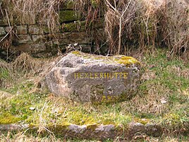
Ritterstein 93 Hexlerhütte in Erlenbach
|
||
Erlenbach is a district of the Elmstein community in the Rhineland-Palatinate district of Bad Dürkheim . Before that, he was part of the Wilgartswiesen community until the end of 1975 .
location
The relatively small place is 350 meters above sea level. It is located about six kilometers southwest of the core community in the middle of the Frankenweide , as the middle part of the Palatinate Forest is called, directly on the boundary with Wilgartswiesen . It lies on the eponymous Erlenbach , the main source stream of the Speyerbach . The place is surrounded by forest areas. One kilometer to the northeast, the brook flows from the Vorderen Loch into the Erlenbach from the right . The 498 meter high Speyerbrunner Eck extends north-west . The closest localities are the annexes Speyerbrunn and Schwarzbach , which also belong to Elmstein, as well as the hamlet Johanniskreuz, which belongs to Trippstadt, and the Wilgartswieser district Hofstätten .
history
The so-called Hexlerhütte was once located on the site of the village ; it was a homestead that was probably inhabited by a Jakob Hexemer . The present-day town of Erlenbach developed from this; Initially it functioned as a forest workers' settlement and was first mentioned in 1788.
According to an official list of localities for the Free State of Bavaria from 1928 , a total of 48 residents lived in eight residential buildings in the hamlet of Erlenbach, which at the time belonged to the rural community of Wilgartswiesen-Hofstätten in the Bavarian administrative district of Palatinate and to the Bergzabern district office . Both the Catholics and the Protestants belonged to Elmstein, the next school was in Speyerbrunn.
After the Second World War , Erlenbach became part of the then newly formed state of Rhineland-Palatinate. Under the first Rhineland-Palatinate administrative reform in 1969, he became part of the now Wilgartswiesen hot congregation of the dissolved district Bergzabern in the district Pirmasens . In the course of land consolidation on January 1, 1976, Erlenbach was slammed together with the neighboring towns of Schwarzbach and Speyerbrunn Elmstein. This was accompanied by another change of circle; since then the place has been in the Bad Dürkheim district .
Culture
On site is the Ritterstein 93 , which indicates the former existence of the Hexlerhütte. It is embedded in a wall that is on the driveway.
Infrastructure
Erlenbach consists exclusively of a few houses. District road 40 , which connects the town with Speyerbrunn , as well as Tour 5 of the mountain bike park Palatinate Forest and the north route of the Palatinate Way of St. James lead through the village . Federal highway 48 runs two kilometers to the west in a north-south direction . There is also a pumping station and a holiday home on site. The closest bus stop is in Speyerbrunn and is called Speyerbrunn, Abzw. Erlenbach . It is only served by school buses on the Schwarzbach – Elmstein route and by buses during the summer season.
Individual evidence
- ↑ michael-joost.de: Mountain bike tour Pfalz: Lambrecht to Elmstein, Erlenbach . Retrieved March 12, 2018 .
- ↑ elmstein.de: Elmsteiner Ortsteile ( Memento from December 2, 2008 in the Internet Archive )
- ^ Localities directory for the Free State of Bavaria , based on the census of June 16, 1926 and the territorial status of January 1, 1928, column 725 ( Digitale-sammlungen.de )
- ↑ Official municipality directory 2006 ( Memento from December 22, 2017 in the Internet Archive ) (= State Statistical Office Rhineland-Palatinate [Hrsg.]: Statistical volumes . Volume 393 ). Bad Ems March 2006, p. 175 (PDF; 2.6 MB). Info: An up-to-date directory ( 2016 ) is available, but in the section "Territorial changes - Territorial administrative reform" it does not give any population figures.
- ↑ ferienhausroute5.de: Activities and surroundings . Retrieved March 7, 2018 .
- ↑ elmstein.de: Apartments . Retrieved March 7, 2018 .
- ↑ rlp-buergerservice.de: 517 (Johanniskreuz -) Iggelbach - Elmstein - / Esthal - Lambrecht - Neustadt . (No longer available online.) Formerly in the original ; accessed on March 12, 2018 . ( Page no longer available , search in web archives ) Info: The link was automatically marked as defective. Please check the link according to the instructions and then remove this notice.

