Appenthal
|
Appenthal
Elmstein municipality
Coordinates: 49 ° 20 ′ 55 ″ N , 7 ° 57 ′ 1 ″ E
|
||
|---|---|---|
| Height : | 222 m above sea level NHN | |
| Residents : | 508 (Dec. 31, 2009) | |
| Postal code : | 67471 | |
| Area code : | 06328 | |
|
Location of Appenthal in Rhineland-Palatinate |
||
|
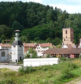
Appenthal townscape
|
||
Appenthal is part of the local community Elmstein in the Rhineland-Palatinate district of Bad Dürkheim , within which it forms the second largest annex after Iggelbach with around 500 inhabitants.
Geographical location
Appenthal is located in the middle of the Palatinate Forest in the Elmsteiner Tal immediately east of the core town at 222 m above sea level. NHN in the valley of the Speyerbach , which flows through the village. Appenthal includes Mühlstrasse and Talstrasse , among others . To the north of the village is the Harzofen annex . The 412 meter high Ehscheid extends to the east and the Weihersberg to the northwest .
history
The place name is derived from an old Palatine name for the field elm , which was called Effer , Affer or Apper depending on the area . This suggests that elms were quite common in the Speyerbach valley, at least during the naming phase.
In 1488 the local pilgrimage church St. Maria was built, the tower of which survived as a ruin. It belonged to the parish of Elmstein. Elector Philip the Sincere endowed two priests here for permanent pastoral care. According to an undated document, around 1510 his son, Elector Ludwig V , founded a weekly vigil with soul mass “for the pious visitors and benefactors” of the pilgrimage church. In 1928 Appenthal had 314 inhabitants who lived in 47 residential buildings. Both the Catholics and the Protestants belonged to the parish of Elmstein at the time.
Infrastructure
The remains of the Marienkirche, called the old tower , shape the townscape. With the support group Kirchenruine Appenthal e. V. there is an association on site that is committed to preserving this building. There is also an old bell tower in Appenthal . With the old tower , the bell tower and a half-timbered house, which is located in Talstrasse, there are a total of three objects on site that are classified as cultural monuments . There is also a cemetery on site and the VfL Elmstein sports field on the south-eastern outskirts .
At the beginning of the 1970s, an artist colony similar to that in Worpswede or Darmstadt emerged on the southern edge of the settlement . A total of three houses remain from this colony, in which a painter , a potter and an inlay artist work.
To the southeast of the settlement area in the immediate vicinity of the railway line and the Speyerbach is the Ritterstein 251 , which bears the inscription Hecker Bridge . The background was the construction of a bridge over the Speyerbach. For this there was a demonstration led by a valley dweller who was called "Hecker"; He received this designation based on the 48 revolutionary Friedrich Hecker .
traffic
The Kuckucksbähnel , which opened in Elmstein in 1909 , also improved traffic conditions for Appenthal; meanwhile it is used exclusively for museum traffic. Although the railway line passes the place, it never had a train stop due to the small spatial distance to Elmstein station. The state road 499, which connects Elmstein to the east with the federal highway 39 and to the west with the federal highway 48 , also runs through Appenthal. District road 22 branches off from here and leads to Harzofen. There is a bus stop for the 517 bus on Landesstraße, which connects Neustadt an der Weinstraße and Iggelbach . During the summer season it also connects Johanniskreuz and Speyerbrunn . Appenthal is also on the Saar-Rhein-Main long-distance hiking trail , which is marked with a yellow cross .
Web links
Individual evidence
- ^ Johann Christoph Adelung : The elm . In: Grammatical-critical dictionary of the high German dialect . 1st edition. Leipzig, S. 791 f . ( lexika.digitale-sammlungen.de - from 1774).
- ↑ elmstein.de: Elmsteiner districts . Retrieved April 7, 2018 .
- ^ Franz Xaver Glasschröder : Documents on the Palatinate Church History in the Middle Ages . Munich 1903, p. 151 f . (Deeds No. 362).
- ↑ List of localities for the Free State of Bavaria. In: daten.digitale-sammlungen.de. Retrieved April 7, 2018 .
- ↑ elmstein.de: Elmsteiner clubs and associations . Retrieved April 7, 2018 .
- ^ General Directorate for Cultural Heritage Rhineland-Palatinate (ed.): Informational directory of cultural monuments - Bad Dürkheim district. Mainz 2020, p. 33 f. (PDF; 5.1 MB).
- ↑ rheinpfalz.de: VfL Elmstein celebrates its new grass pitch on Saturday . Retrieved April 7, 2018 .
- ↑ Inlaid design Bettina Seckler. Retrieved April 7, 2018 .
- ↑ rlp-buergerservice.de: 517 (Johanniskreuz -) Iggelbach - Elmstein - / Esthal - Lambrecht - Neustadt . Retrieved March 12, 2018 .

