Long-distance hiking trail Saar-Rhein-Main
| Long-distance hiking trail Saar-Rhein-Main | |
|---|---|
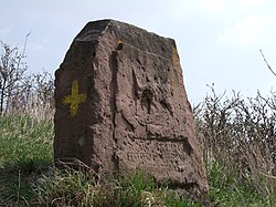
 Stone cross with the yellow cross on the side |
|
| Data | |
| length | ≈ 200 km to 286.5 km |
| location | Palatinate Forest , Rheinhessen , Lower Franconia |
| Markers |
|
| Starting point |
Homburg 49 ° 19 ′ 14.7 " N , 7 ° 20 ′ 35.1" E |
| Target point |
Woerth am Main 49 ° 46 ′ 46.8 ″ N , 9 ° 11 ′ 3.5 ″ E |
| Type | Long-distance hiking trail |
| Height difference | 417 m |
| The highest point | 502 |
| Lowest point | 85 |
| season | all year round |
| Viewpoints | Petersberg |
| particularities | West and East route |
The Saar-Rhein-Main long-distance hiking trail runs with the Yellow Cross sign from the Saar over the Rhine to the Main .
society
The hiking trail between Homburg and Alsheim (train station), 190 km away, is looked after by the Palatinate Forest Association and from there to the destination in Klingenberg, 91 km away, by the Odenwald Club .
Markers
A yellow cross with cross arms of equal length serves as a marker for the Saar-Rhein-Main long-distance hiking trail. Since there is no further indication of the next point of the route or directional information besides the marker, it is advisable to have a suitable hiking map or navigation device with appropriate route guidance with you.
Route
The long-distance hiking trail begins in Homburg, Saarland, at the Schlossberg caves on the Schlossberg. Behind Kirrberg it crosses the border to the federal state of Rhineland-Palatinate and initially runs through the hill country of the Westrich plateau ; Winterbach and Höheinöd , among others, are affected. At Waldfischbach it reaches the Palatinate Forest , where it is led over the Hundsweihersägemühle and through the Schwarzbachtal to Johanniskreuz . From there it goes along the Speyerbach via Elmstein and Erfenstein to Lambrecht and finally up to the Pfälzerwald club hut Lambertskreuz . The last section of the route within the Palatinate Forest leads over the Hardenburg , Altleiningen and Eisenberg into the North Palatinate Bergland . Here the hiking trail touches the communities of Weitersweiler , Marnheim , Kirchheimbolanden , Bischheim and Ilbesheim . It then reaches Rheinhessen and here first of all Freimersheim and Alzey . From there it goes along the Selz to Framersheim and Gau-Odernheim on the Petersberg ; After crossing it, the route runs through the local community of Bechtolsheim back to Selz, which you follow to Friesenheim . From Friesenheim, the long-distance hiking trail to Oppenheim am Rhein uses the Valtinche cycle path . From Oppenheim it leads up the Rhine on the Rheinterrassenweg via Ludwigshöhe , Guntersblum and Alsheim . At the Alsheim train station, the Odenwaldklub takes over responsibility from the Palatinate Forest Association. From Alsheim the path leads through the sand and past the Old Rhine Adventure Path to Eich and then to the Rhine .
He crosses this at Gernsheim , for which a ferry is used. You have now reached the state of Hesse . As 'main hiking trail 14' it first runs through the Rhine valley to Bickenbach and crosses the northern Odenwald from the Seeheim district . Among other things, Neutsch , Lichtenberg , Brensbach , Grumbach and Höchst in the Odenwald are touched until the Main and thus the destination of the long-distance hiking trail in Wörth or Klingenberg is reached.
The 286.48 km long hiking trail has a height difference of 417 meters, the lowest point is at the Rhine crossing at 85 meters above sea level, the highest point is at 502 meters at the Hinteren Stoppelkopf in the Palatinate Forest. Since it mainly goes through two low mountain ranges (Palatinate Forest, Odenwald) and numerous hilly landscapes, the total ascent is 6,135 meters and the total descent is 6,282 meters.
See also
Web links
- (Homburg) Alsheim - Lichtenberg - Klingenberg (Main) (private)
- Homburg - Wörth am Main (286.5 km) on berge-gipfel.de
- Alsheim, Lichtenberg, Klingenberg am Main (91 km)
- Main hiking trails of the Odenwald Club HW14: Alsheim – Klingenberg am Main
- Verbandsgemeinde Göllheim
Individual evidence
- ↑ Directory of the hiking trails of the Odenwaldklubs eV - On safe paths - Hiking trails of the Odenwaldklubs eV p. 14; as a PDF file 317 kB
- ↑ gpsies.com
