High stubble head
| High stubble head
(Rear stubble head, stubble head)
|
||
|---|---|---|
|
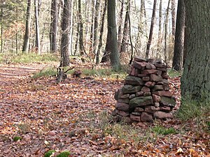
"Steinmann" as a signpost near the Hohe Stoppelkopf |
||
| height | 566.2 m above sea level NHN | |
| location | near Deidesheim ; Bad Dürkheim district , Rhineland-Palatinate ( Germany ) | |
| Mountains | Palatinate Forest | |
| Coordinates | 49 ° 23 '50 " N , 8 ° 4' 25" E | |
|
|
||
| rock | Red sandstone | |
| particularities | Hermannshütte | |
The high stubble head , also called the rear stubble head , regionally mostly just called stubble head , is 566.2 m above sea level. NHN high mountain in the Palatinate Forest ( Rhineland-Palatinate ).
geography
location
The Hohe Stoppelkopf rises in the Palatinate Forest part of the Middle Palatinate Forest as well as in the Palatinate Forest Nature Park and in the Palatinate Forest-Vosges du Nord Biosphere Reserve . Its summit is 3 km north of Lambrecht and 2.3 km east-northeast of Neidenfels on the forest delimitation of the city of Deidesheim , whose residential development is 8.3 km east-northeast of the summit. The border to the forest area of Wachenheim an der Weinstrasse runs over the high elevations of the northern flank of the mountain .
Natural allocation
The Hohe Stoppelkopf belongs to the Palatinate Forest natural area, which is classified as a third-order Greater Region in the systematics of the handbook on the natural structure of Germany published by Emil Meynen and Josef Schmithüsen and its subsequent publications . If you look at the internal structure of the natural area , it belongs in particular to the Middle Palatinate Forest.
In summary, the natural spatial allocation of the Hohe Stoppelkopf follows the following system:
- Greater region 1st order: Layer level land on both sides of the Upper Rhine Rift
- Greater region 2nd order: Palatinate-Saarland layer level land
- Greater region 3rd order: Palatinate Forest
- 4th order region (main unit): Middle Palatinate Forest
Waters
Together with Engelskopf ( 441 m ) and Drachenfels ( 571 m ) in the north-west and Steinkopf ( 528 m ), Eckkopf ( 516 m ) and Stabenberg ( 496 m ) to the east, the Hohe Stoppelkopf in the Palatinate Forest forms the watershed between the catchment areas of two left tributaries of the Rhine , namely the Speyerbach (south) and the Isenach (north). The two source brooks of the Mußbach , which later flows into the left branch of the Speyerbach, the Rehbach , arise on the north-eastern slope of the mountain, in the Wachenheim district .
Facilities and tourism
The Hermannshütte (also Emil-Leidner-Hütte ) hunting lodge was built in 1900 about 110 m north-northeast of the summit of the wooded Hohen Stoppelkopf ; it is not cultivated. The Palatinate Forest Association , local group Deidesheim, erected a summit cross on the summit in 2003 . 2 km northeast of it is a big game protection park, the Kurpfalz-Park , the Wachenheim out on the county road (km 8) 16 is achievable.
Individual evidence
- ↑ a b Map service of the landscape information system of the Rhineland-Palatinate Nature Conservation Administration (LANIS map) ( notes )
- ↑ Adalbert Pemöller: Geographical land survey: The natural spatial units on sheet 160 Landau i. d. Palatinate. Federal Institute for Regional Studies, Bad Godesberg 1969. → Online map (PDF; 4.2 MB).
- ↑ Helmut Beeger u. a .: The landscapes of Rheinhessen-Pfalz - naming and spatial delimitation. In: Reports on German regional studies , Volume 63, Issue 2, Trier 1989, pp. 327–359.
- ↑ a b Night hike by PWV Esthal. Mittelpfalz.de, accessed on September 17, 2014 .
- ^ "Hermanns-Hütte" at the rear Stoppelkopf. tourenwelt.info, accessed on September 17, 2014 .
- ↑ Experience wildlife and nature ( memento from September 16, 2014 in the web archive archive.today ) (Kurpfalz-Park), accessed on September 16, 2014, from kurpfalzpark.de

