
Mußbach (Rehbach)
| Mustbach | ||
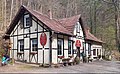
 The Mußbach on the south-eastern outskirts of Gimmeldingen, on the left the north face of the Wiedemann mill |
||
| Data | ||
| Water code | DE : 237982 | |
| location | Germany | |
| River system | Rhine | |
| Drain over | Rehbach → Rhine → North Sea | |
| source | at the high stubble head 49 ° 24 ′ 25 ″ N , 8 ° 4 ′ 33 ″ E |
|
| Source height | 360 m above sea level NHN | |
| muzzle | near Neustadt- Mußbach from the left in the Rehbach coordinates: 49 ° 21 '33 " N , 8 ° 10' 58" E 49 ° 21 '33 " N , 8 ° 10' 58" E |
|
| Mouth height | 124 m above sea level NHN | |
| Height difference | 236 m | |
| Bottom slope | 20 ‰ | |
| length | 11.9 km | |
| Catchment area | 15.238 km² | |
| Left tributaries | Bach from the Seekopf, Bach from the ashlar slope source | |
| Right tributaries | Silbertalbach , brook from the Loosenbrunnen | |
| Reservoirs flowed through | several reservoirs in the Kurpfalz-Park , one reservoir in the Gimmeldinger Valley | |
| Medium-sized cities | Neustadt an der Weinstrasse | |
| Small towns | Wachenheim an der Weinstrasse , Deidesheim | |
| Absorption of the water from Siebenröhrenbrunnen , Quaderhangquelle , Loosenbrunnen , Loogquelle and Neumühlquelle | ||
The Mußbach in the east of the Palatinate Forest and in the Vorderpfalz ( Rhineland-Palatinate ) is an almost 12 km long stream and a left tributary of the Rehbach . The wine-growing village Mußbach is named after him, through which it flows and which was incorporated into the town of Neustadt an der Weinstrasse in 1969 as a district .
course
In the low mountain range

Swan pedal boat on one of the reservoirs in the Kurpfalz Park

Forsthaus Benjental

Loosenbrunnen in the Weinbiet
Looganlage inn

Left above the stream: Mußbach waterworks (1899)


Two sources of the Mußbach arise, only 300 m apart, on the northern slope of the Hohen Stoppelkopf ( 566 m above sea level ) on the forest area of Wachenheim an der Weinstrasse , the main source on the right at 360 m , the left at 350 m . After about 500 m the processes flow together. As soon as the initially rapidly flowing Mußbach has absorbed the water from the Siebenröhrenbrunnen at an altitude of 320 m , it enters the Kurpfalz-Park , a 70 hectare leisure and wildlife park. There the stream flows a good 1 km to the east, feeding several small reservoirs on which the park operator offers various watercraft. At the confluence of an approximately 800 m long brook that comes from the left, from the 532 m high Seekopf and first fills the largest reservoir in the park, the Mußbach turns right and leaves the park 500 m further south. In the Silbertal , where the 1.4 km long Silbertalbach flows towards it from the right , the Mußbach crosses the border to the Deidesheim forest area and turns to the southeast. About 2 km further on, a 700 m long brook flows from the left, which comes from the ashlar slope spring .
In the Benjental , the Mußbach reaches the forest area of the Neustadt district of Gimmeldingen after a total of 6 km . At the Looganlage , a tributary flows from the right at a height of about 220 m , which is only 1 km long, but richer in water. It rises, contained in the Loosenbrunnen , at a height of 460 m on the northern flank of the Weinbiet , whose 554 m high summit with two striking towers characterizes the eastern edge of the Middle Palatinate Forest . From 1952 to 1988, spring water was pumped up from the well as drinking water to the Weinbiethaus excursion restaurant . On the bottom of the Gimmeldinger valley , the combined stream flows more slowly. It absorbs the water from the Loog and Neumühl springs and then feeds a small reservoir that is used for tourism .
In the plane
With the breakthrough through the Haardt , the eastern edge of the Palatinate Forest, the Mußbach leaves the low mountain range and reaches the Vorderpfalz . There it flows through the hilly vineyards on both sides of the German Wine Route through the residential areas of Gimmeldingen and Mußbach. On the field markings it flows 2 km southeast of the residential development, now in the Rhine plain , at 124 m height from the left into the Rehbach, the northern branch of the Speyerbach .
In the east and south-east of the residential area of Mußbach there are two weirs at which, in the past, part of the stream water was inadmissibly diverted to the left into the so-called Langgraben in order to irrigate allotment gardens . That is why the city of Neustadt had a metal plate attached to the northern weir in March 2015 to prevent water from draining off. However, since strangers removed the plate several times over the next two months, the connecting pipe was dug up with an excavator and the supply line was filled in.
The right branch of the mouth of the Langgraben reaches the former streambed of the Rehbach 500 m below the mouth of the Mußbach; This was because in the 1980s when the local section of federal highway 38 was expanded, it was moved from its north to the south side. After about 100 m the old Rehbach is led under the main road to the new creek bed. The left branch of the Langgraben flows into the Rehbach about 1.5 km below the mouth of the Mußbach.
250 m north-east of the Mußbach estuary, a 100 m long and 30 to 60 m wide reservoir extends on the Stenten weir west of state road 532 . The wetland has no connection to the Mußbach or other flowing waters and is only fed by groundwater .
history
Surname
Already in Middle High German the watercourse and after it the place through which it flows on the lower course was called “Muosbach”, which means something like “mossy brook” in the sense of “ swampy ”; because watercourses that were left in their natural state meandered at the time and caused a high water table in the area.
Mills
In the Middle Ages , the water of the brook was used to operate twelve water mills and jet engines, the locations of which are connected by a mill trail . These include, listed from the Mußbach spring to the mouth:

- Due to the location, the top mill on the Mußbach was called Obere Mühle .
- Today's forester's house, Benjental, used to be a coat of arms forge that used Mußbach water to power the iron hammer . Up to this point, all mills and engines were within the Deidesheim district.
- The lower mill in the far north-west of Gimmeldingen was built in 1718 and has been in ruins since a major fire in 1886.
- The Platsche Mühle was built in 1821 and closed in 1900. A millstone has been preserved.
- The best preserved building is the valley mill , which has been converted into a restaurant.
- Already in Franconian times there was a mill south of the Nikolauskirche on the boundary of the former village of Lobloch , which historians believe to be the nucleus of the village, which opened up in 1751 in the neighboring village of Gimmeldingen.
- The Wiedemannsche Mühle in the extreme southeast of Gimmeldingen on the border with Mußbach was in operation until the beginning of the 20th century and was then converted into a wine-growing business . The former mill wheel could still be viewed in the 1960s.
ecology
In the 19th and into the second half of the 20th century, the stream in Gimmeldingen and in the lower eastern half of Mußbach was used as a sewer . On the section in between, the stream water was clarified in concrete basins on the southwest edge of Mußbach until the 1960s , in order to be used to operate the Mußbach swimming pool.
In the meantime, the stream has been partially renatured , but also partially piped.
literature
- Erich Metz, Alfred Sitzmann: The former grinding mills on the Mußbach . In: Reinhard Kermann, Alfred Sitzmann (Hrsg.): Gimmeldingen - life in the wine village . Neustadt an der Weinstrasse 2008.
Individual evidence
- ↑ a b Map service of the landscape information system of the Rhineland-Palatinate Nature Conservation Administration (LANIS map) ( notes )
- ↑ a b GeoExplorer of the Rhineland-Palatinate Water Management Authority ( information )
- ↑ Wolfgang Kreilinger (wkr): Mußbach: With the excavator against water thieves . In: Die Rheinpfalz , local edition Mittelhaardter Rundschau . No. 106 . Ludwigshafen May 8, 2015, p. 13 .
- ↑ Findings on site by user Grünspecht2014 in 2014.
- ↑ Mühlenwanderweg. (No longer available online.) Stadt Neustadt / Weinstrasse, archived from the original on March 30, 2012 ; Retrieved February 15, 2011 . Info: The archive link was inserted automatically and has not yet been checked. Please check the original and archive link according to the instructions and then remove this notice.
- ↑ Eselsweg, Stabenberg and Almond Blossom. Hiking in the Palatinate, accessed on February 15, 2011 .
- ↑ Erich Metz, Alfred Sitzmann: The former grinding mills on the Mußbach . 2008, p. 44-51 .