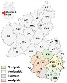
Front Palatinate
The Vorderpfalz together with the Southern Palatinate of Palatine share in the Upper Rhine Valley . In addition, the Palatinate Forest , the North Palatinate Bergland and the West Palatinate are the large sub-landscapes of the Palatinate.
In linguistic usage there is the "Vorderpfalz" as an equivalent to "Westpfalz". "Ostpfalz" was never used. When the Palatinate came under Bavarian rule in 1816 , the new administration coined the term “Hinterpfalz” for the western Palatinate; but this term is only rarely used today - especially in the Vorderpfalz.
geography
Limits and altitude
Natural borders of the Vorderpfalz are the Haardt in the west as the eastern edge of the Palatinate Forest and in the east the Rhine . In the north the Vorderpfalz borders on Rheinhessen , in the south on the Südpfalz . The altitude ranges from about 150 m above sea level. NHN on the German Wine Route in the west and 90 m on the Rhine in the east.
Winzinger Wassergescheid on the northeastern edge of Neustadt
Blue Adriatic recreation area near Ludwigshafen am Rhein
structure
The Vorderpfalz is divided into the hill country on the German Wine Route, the actual Rhine plain and the Rhine lowlands.
The vineyards of the northern half of the Palatinate wine-growing region extend on both sides of the German Wine Route . This was formerly in Central and sub Haardt divided before the area in the early 1970s Mittelhaardt-German Wine Route was summarized.
The actual plain is characterized by orchards, fruit and vegetable cultivation and also by small wooded areas such as - east of Neustadt an der Weinstrasse - the Ordenswald . To the north of the Neustadt – Speyer connection , between the Weinstrasse and the Ludwigshafen area, there is an almost flat area in which fruit and vegetable cultivation dominates. North of the Bad Dürkheim –Ludwigshafen line, the landscape gradually merges into the Rheinhessen hill country .
The Rhine lowland is the area in which the Rhine had its changing course in earlier times before it was regulated in the 19th century . The transition can sometimes be seen clearly as a high bank about 7 m high. The backwaters of the Rhine flow in the Rhine lowlands . There was and is often by gravel or sand dredged, making numerous lakes are created or old waters were extended. Parts of the floodplain are under nature protection . The arms of the old Rhine with their distinct bends form islands, for example the island of Flotzgrün near Römerberg , which is surrounded by the Berghäuser Altrhein, north of Speyer the fishing forest within the Angelhofer Altrhein and the Kollerinsel , surrounded by the Otterstädter Altrhein. After the Old Rhine was interrupted by a road embankment, the latter is actually a peninsula; Although it has been on the left bank of the Rhine since the Rhine was straightened , it belongs to the municipality of Brühl and thus to Baden-Württemberg , as it did before .
Watercourses
Streams flow through the Vorderpfalz from west to east, all of which are left tributaries of the Rhine. Down the Rhine (from south to north) it is:
-
Speyerbach : Neustadt – Speyer
- from Winzinger Wassergescheid to the confluence of the left side arm Rehbach : Neustadt - Schifferstadt - Ludwigshafen
- from Hanhofer Wassergescheid until shortly before left the mouth of tributary Woogbach which at Speyer also Nonnenbach called
- through Speyer Gießhübelbach , which flows into the Nonnenbach in the old town of Speyer
- Isenach : Bad Dürkheim - Frankenthal - Bobenheim-Roxheim / Worms
- Eckbach : Kleinkarlbach - Dirmstein - Worms
- Eisbach : Grünstadt - Obrigheim - Worms
Political structure
Districts and independent cities of the Vorderpfalz are:
- Bad Dürkheim district
- City of Frankenthal (Palatinate)
- Rhein-Pfalz-Kreis (formerly: Ludwigshafen district)
- City of Ludwigshafen am Rhein
- City of Neustadt an der Weinstrasse
- City of Speyer
The areas of the Bad Dürkheim district and the cities of Landau and Neustadt extend in the west beyond the geographical boundaries of the Vorderpfalz and far into the Palatinate Forest.
The Vorderpfalz in this political sense is, together with other districts and cities from Rheinhessen , Hessen and Baden-Württemberg , also part of the Rhine-Neckar metropolitan region ( portal ).
literature
- Georg Heeger: The Germanic settlement of the Vorderpfalz on the hand of the place names . Landau 1900, urn : nbn: de: 0128-1-17589 .


