
Eckbach (Rhine)
|
Eckbach (also the Eck , on the Unterlauf Neugraben and Leininger Graben ) |
||
 River course of the Eckbach (below) |
||
| Data | ||
| Water code | DE : 23916 | |
| location |
Haardt Mountains
|
|
| River system | Rhine | |
| Drain over | Rhine → North Sea | |
| source | in Carlsberg - Hertlingshausen 49 ° 29 ′ 47 ″ N , 8 ° 0 ′ 52 ″ E |
|
| Source height | 311 m above sea level NHN | |
| muzzle | in Worms from the left into the Rhine Coordinates: 49 ° 36 '30 " N , 8 ° 24' 7" E 49 ° 36 '30 " N , 8 ° 24' 7" E |
|
| Mouth height | approx. 86 m above sea level NHN | |
| Height difference | approx. 225 m | |
| Bottom slope | approx. 5.7 ‰ | |
| length | 39.3 km | |
| Catchment area | 217.847 km² | |
| Discharge at the Großkarlbach A Eo gauge : 63.2 km². Location: 19.2 km above the mouth |
NNQ (05/07/1964) MNQ 1958/2009 MQ 1958/2009 Mq 1958/2009 MHQ 1958/2009 HHQ (05/18/1982) |
9 l / s 52 l / s 148 l / s 2.3 l / (s km²) 1.56 m³ / s 7.64 m³ / s |
| Left tributaries | s. Section tributaries | |
| Right tributaries | s. Section tributaries | |
| Reservoirs flowed through | Eckbachweiher | |
| Medium-sized cities | Worms | |
| Communities | s. History section | |
| Residents in the catchment area | 120,000 | |
| The main supplier of Eckbach water today is the 20-tube fountain in Altleiningen . | ||
The Eckbach , in the Middle Ages Leinbach , also known as the Eck in the region , on the Unterlauf Neugraben and Leininger Graben , is a 39 km long stream and a left or western tributary of the Rhine in Rhineland-Palatinate . There it flows mainly in the northeastern Palatinate , only the last 2 km of the brook and its mouth are in the extreme southeast of Rheinhessen . The Eckbach-Mühlenwanderweg accompanies him on the first 23 km of his run .
Name and etymology
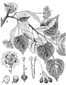
Summer linden:
undivided leaf blade, five-pointed flower
Leininger family coat of arms: stylized tree with linden leaves


Linguistic research traces the old name die Eck back to the river or brook name Ache , which is still common today in southern Germany and is used as a feminine term , and which has been passed down from Old High German as aha .
In the Middle Ages, the Eckbach was called Leinbach , which refers to the "Leinbaum". At that time, both the Norway maple and the summer linden were called in the area , two tree species that were common on the banks of the Eckbach. However, the main difference between the two is the shape of the leaves: maple leaves are five-lobed, linden leaves are undivided.
The coat of arms of the Leininger family shows a stylized tree, whose leaves - like the five-pointed flowers - clearly indicate a linden tree.
The noble family of the Leininger , who come from the area at the upper Eckbach, may have named their ancestral castle after the old Bach name, from which the later name of the family was derived.
That the original Eck now called Corner brook carries, going to the Kingdom of Bavaria back to the left bank of the Palatinate from 1816 belonged. When the Bavarian officials mapped the Palatinate at that time , they wanted to make it clear - not knowing how the name came about - that the corner was a brook. As a result, today's "Eckbach" means something like "Bachbach" in linguistic terms.
geography
course

The Eckbach rises in Carlsberg in the northern Palatinate Forest . Seine in sandstone aggregate source is located southeast of the Highway 6 ( Saarbrücken - Mannheim ) in the district part Kleinfrankreich of Carlsberg hamlet Hertlingshausen to 311 m above sea level. NHN . The source of the stream is marked by a so-called knight's stone (No. 286). The upper Eckbach represents the central flowing water for the surrounding south-western Leiningerland . On the municipal side, the Isenach-Eckbach Water Association is responsible for the care of the river , which is subordinate to the Bad Dürkheim district .
Initially, the brook flows east through Hertlingshausen, then north-east through Altleiningen , where it draws most of its water from the 20-tube fountain . At the north-eastern exit of Altleiningen, the Rothbach (9.85 km long) first flows from the left and then the Höninger Bach (5.85 km) from the right .
After flowing through the Eckbachweiher near Neuleiningen-Tal , which was created in the Middle Ages as a water reservoir for two mills , the Eckbach breaks through the Leininger Spur , the northeastern edge of the Palatinate Forest, between the villages of Neuleiningen in the north and Battenberg in the south , located up near their castles of the same name , and turns for 6 km in an easterly direction. In doing so, he reaches the hill country with vines on both sides of the German Wine Route near Kleinkarlbach , where the 6.8 km long Krumbach flows into it .
In Kirchheim the Eckbach crosses under the federal road 271 running in north-south direction and takes the 780 m long Seebergraben from the left ; then it flows through Bissersheim . From here it passes Großkarlbach . There it is covered for a stretch in Kändelgasse with a five to six meter wide sandstone vault that serves as a sidewalk and leads over the property entrances. Because "cracks, damaged abutments, deformations and leached joints" impair safety and there is therefore a "risk of collapse", the vault is to be renovated in 2015 and 2016. Below Großkarlbach, the Eckbach crosses, now again in a north-easterly direction, the Autobahn 6 and then flows on through Laumersheim .

In Dirmstein , where the direction of flow changes again to east, the 8 km long Floßbach flows from the left on the eastern edge of the residential development , which is also called Landgraben on the upper reaches and is the backwaters of the Eckbach with the most water. To the left or north of the stream, the structure of the hill country is clearly pronounced. There, an elongated, low ridge, marked by three hilltops, forms the watershed towards the Eisbach : the Wörschberg ( 163 m ) north of the connecting road Obersülzen -Dirmstein, the Schneckenberg ( 143 m ) between Dirmstein and Offstein and the Stahlberg ( 134 m ) between Dirmstein and the Heppenheim district of Worms .
The area to the right or south of the Eckbach is flatter and in the Großkarlbach – Laumersheim – Dirmstein – Gerolsheim area was previously a swampy lowland that was used as pastureland. To the south of this lies the watershed to the Fuchsbach, which flows parallel to the south . Until the end of the 18th century, this flowed directly into the Rhine from the left. Then it became a left tributary of the Isenach , which was then diverted to the north , until in the second half of the 20th century most of the water from the Fuchsbach was diverted to the Schrakelbach and thus to the Eckbach. The area between Laumersheim, Dirmstein, Gerolsheim and Heuchelheim , through which the Autobahn 6 also runs, is still criss-crossed by irrigation ditches that are derived to the right from the Eckbach. After 6 to 8 km they flow back into it, sometimes directly, sometimes only after they have previously united or gathered in the Schrakelbach: Weihergraben , Altbach , Kühweidegraben , Oberer Altgraben , Bittinggraben and Lerchengraben .
In Dirmstein the Eckbach enters the western part of the Upper Rhine Plain . It is bridged by Autobahn 61 to the east of Heuchelheim and north of the Frankenthal motorway junction . North of Beindersheim, the Eckbach bends significantly to the north-northeast; there the 6.9 km long Schrakelbach flows from the right. In the further course of the Eckbach passes the villages of Großniedesheim and Kleinniedesheim on the east side, where the 2.4 km long Hollergraben flows from the right . The Eckbach Bobenheim, the northern part of the municipality of Bobenheim-Roxheim , crosses predominantly northeastward . Then it steers, diverted and canalized for about 1 km, as a new dig to the north and turns southeast of the Worms airfield to the east.
Ultimately, the Eckbach reaches the district of the Rhine-Hessian city of Worms within the Wormser Ried nature reserve , where it is called Leininger Graben from the city limits and is bridged by federal highway 9 . There he takes up the 3.5 km long Karl-Marx-Graben from the left. After the Eckbach has passed the Bürgerweide Worms to the south, it flows into the Upper Rhine from the left at a height of about 86 m .
The difference in altitude of 225 m between the source and the mouth, based on the length of the water body of 39.3 km, results in a mean bed gradient of 5.7 ‰.
Tributaries
The following list contains all tributaries of the Eckbach, which are recorded with the river code number:
| Surname |
page |
Length [km] |
EZG [km²] |
Mouth on km |
Mouth |
GKZ |
|---|---|---|---|---|---|---|
| Bach from the Frauental | right | 1.53 | 2.56 | 1.69 | Hertlingshausen | 23916-12 |
| Bach from the Kirchheim valley | right | 2.12 | 2.08 | 2.87 | below Hertlingshausen | 23916-14 |
| Bach from the Keystone | right | 0.94 | 1.37 | 3.26 | below Hertlingshausen | 23916-16 |
| Rothbach | Left | 9.85 | 19.30 | 6.78 | Altleiningen | 23916-2 |
| Höninger Bach | right | 5.85 | 12.83 | 7.54 | below Altleiningen | 23916-4 |
| Bach in the Spechttal | right | 0.38 | 0.55 | 8.11 | below Altleiningen | 23916-5112 |
| Krumbach | right | 6.84 | 7.06 | 14.19 | Kleinkarlbach | 23916-52 |
| Seebergraben (Schlossbach) | Left | 0.78 | 2.33 | 15.91 | Kirchheim | 23916-5912 |
| Floßbach | Left | 8.10 | 18.76 | 23.52 | on the eastern edge of Dirmstein | 23916-6 |
| Schrakelbach | right | 6.93 | 70.94 | 28.02 | north of Beindersheim | 23916-8 |
| Hollergraben (Hollersgraben) | right | 2.37 | 1.88 | 30.69 | southeast of Kleinniedesheim | 23916-9112 |
| Karl-Marx-Graben | Left | 3.52 | 15.35 | 38.73 | between Bobenheim and Worms | 23916-96 |
nature


In 2004 and 2007, the Alte Sandkaut Dirmstein environmental association alerted the authorities responsible for water protection because environmentally hazardous substances had been introduced into the Eckbach above Dirmstein - in 2007 combined with an intense blue coloration of the water - which temporarily destroyed almost all life in the stream had. In both cases, dead fish floated en masse in the water. It was never possible to clarify who had carried out the two-time discharge of pollutants.
Increasing abandonment of the Eckbach area and renaturation measures enabled the return or the new occurrence of rare plant and animal species. In the early winter of 2012, great egrets , which are actually native to Europe further south and east, were observed for the first time at the Eckbach near Dirmstein.
Nutrias (Myocastor coypus) have been living on the section of the stream between Laumersheim and Dirmstein since 2014 . The European inventory of these from South America coming rodents can be attributed to individuals who have escaped from fur farms prior periods or were deliberately reintroduced. Nutrias are the second largest rodents found in Europe after the beaver and can weigh up to 10 kg. In contrast to the beaver, they do not build dams , but prefer to dig their structures in the banks of watercourses. In 2015, the Alte Sandkaut environmental association registered a male and a mother with six cubs; some of the animals were photographed. The two buildings were above the residential development of Dirmstein, that of the male a little more upstream to Laumersheim.
In 2015, in the same Eckbach area, various dragonfly species , stone flies , quiver flies and mayflies , strudelworms , mud tube worms , various species of leeches, as well as mud snails and even the river mussel , which were considered extinct here, were found.
Attractions
- At the upper Eckbach

Altleiningen Castle with swimming pool in the moat ...

... and youth hostel
20 tube fountain

Felsenmühle, Neuleiningen Valley

Neuleiningen Castle, ruins of the palace and keep ...

... and the castle chapel as a parish church


Castles
The castles Altleiningen , Neuleiningen and Battenberg are located above the Eckbachtal on the heights of the Palatinate Forest and its foothills . Altleiningen Castle has been hosting theater performances by the Altleiningen Castle Games during the summer months since 1980 .
20 tube fountain
The 20-tube well in Altleiningen is fed from a tunnel that was driven deep into the rock around 1600 to supply the castle above. The Eckbach gets most of its water supply from this well. Its actual source 5 km upstream no longer pours water all year round due to the lowering of the groundwater level .
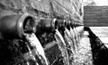
"Flash tubes"
The on the access road to Battenberg located flash tubes are a natural monument. They owe their name to a scientific error.
Leininger valley railway
Between Kleinkarlbach and Altleiningen there used to be a 6 km long section of the Leininger Talbahn , which carried people and goods, parallel to the Eckbach .
Historical washing area
On the hillside south of the Eckbach, west of the Neuleiningen valley, is the historic Neuleiningen washing area from the 19th century, one of the few remaining facilities of this type. It is spanned by a steel bridge of the Leininger valley railway that still exists.
Eckbach mill hiking trail
The Eckbach -Mühlenwanderweg has been running along the Eckbach since 1997 . It initially only ran through seven villages that belonged to the then Grünstadt-Land association . Later it was extended to a total of 23 km to the Eckbachquelle near Hertlingshausen (at that time the Hettenleidelheim Association ). All neighboring communities on the Mühlenwanderweg have been part of the Leiningerland community since 2018 .
- Down the Eckbach
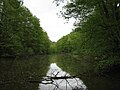
Eckbachweiher

Battenberg Castle, tower
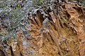
Flash tubes near Battenberg

Village mill with mill museum

Marking of the mill trail

Marking of the Salier cycle path


Eckbachweiher
The Eckbach is dammed in the area from Neuleiningen valley to Eckbachweiher . In the past 35 water mills were operated all the way down to Dirmstein, 23 of which are still more or less preserved and partially restored.
Mills
In 2007 , the Leiningerland Mill Museum was opened in the restored Großkarlbacher Dorfmühle , which dates back to the Middle Ages . Other mills worth seeing are u. a. the Felsenmühle operated as a hotel-restaurant in Neuleiningen-Tal and the Spormühle in Dirmstein , today a sponsoring and event agency. The former Niedermühle in Dirmstein was converted into a farm in the 19th century .
Laurentiuskirche Dirmstein
The Laurentius Church in Dirmstein is a special gem of Baroque architecture, which was built from 1742 to 1746 according to plans by the church builder Balthasar Neumann and the local building contractor Franz Rothermel . The Eckbach, which used to flow through the village only 50 m south of the church, was relocated to the southern edge of the village in the 1920s.
Salier cycle path
Since 2007, the Salier cycle path , which connects a number of monuments from the time of the Salian ruling dynasty , has crossed the Eckbach mill hiking trail in Dirmstein.
Castle-like mansions
Several castle-like mansions have been partially or fully preserved in Dirmstein, including the Sturmfedersche , Koeth-Wanscheidsche and Quadtsche Castle .
Refurbished town centers
The overall impression of most of the neighboring communities, especially in Neuleiningen , Großkarlbach and Dirmstein , is determined by the redeveloped town centers, some of which date from the Middle Ages, but mostly from the Baroque period. At the beginning of the 18th century, the fire damage caused by the French soldiers in the Palatinate War of Succession (1688–1697) was repaired in many places .
- Dirmstein

Spur mill

former Niedermühle

Laurentiuskirche

Storm spring lock

Koeth-Wanscheidsche Castle

Quadtsches Castle


Web links
- SGD Süd : Overall water management concept for the catchment area of Isenach and Eckbach (PDF file; 2.81 MB)
Individual evidence
- ↑ a b Map service of the landscape information system of the Rhineland-Palatinate Nature Conservation Administration (LANIS map) ( notes )
- ↑ a b c d GeoExplorer of the Rhineland-Palatinate Water Management Authority ( information )
- ^ German Hydrological Yearbook Rhine Region, Part I 2009 State Institute for Environment, Measurements and Nature Conservation Baden-Württemberg, p. 133, accessed on January 22, 2016 (PDF, German, 1.85 MB).
- ↑ Albert H. Keil: Bavarian "Language Heritage". PfalzMundArt publishing house, accessed on October 16, 2012 .
- ↑ Natalie Sudermann (nasu): 2015 no Kändelgassenfest . In: Die Rheinpfalz , local edition Frankenthaler Zeitung . Ludwigshafen February 3, 2015.
- ↑ With km the Eckbach-kilometers downstream from the source meant.
- ↑ a b c d Kirsten Hönicke: Eckbach has recovered well . In: Die Rheinpfalz , local edition Frankenthaler Zeitung . Ludwigshafen August 13, 2015.
- ^ Klaus Petermann: Rare guests . In: Umweltverein Alte Sandkaut Dirmstein e. V. (Ed.): Rundmail . Dirmstein December 5, 2012 (observation by Otto Frey).
- ↑ Eva Briechle: A dream come true in the old walls. In: The Rhine Palatinate . April 9, 2019, accessed November 29, 2019 .