
Bundesstrasse 271


The federal road 271 (abbreviation: B 271 ) runs as a federal road in Rhineland-Palatinate from Neustadt an der Weinstrasse in the south in a north to north-westerly direction to Alzey in the north. It is 52 km long.
course


The B 271 begins in the Palatinate on the district of Neustadt an der Weinstraße at junction 11 Deidesheim of the A 65 ( Ludwigshafen - Karlsruhe ). A few kilometers away in Neustadt- Diedesfeld is the geographic center of the German Wine Route , with the northern section of which the B 271 between Neustadt and Bockenheim used to be generally identical. Since the creation of bypasses , which usually run east parallel to the German Wine Route, this is only the case where such bypasses are still missing.
Initially as a motor road and, so to speak, as a series of bypasses, the B 271 leads past the small towns of Deidesheim and Wachenheim as well as the core town of Bad Dürkheim at approximately the same distance from the break edge of the Upper Rhine Graben to the west . To the northeast of this, in the district of Ungstein , it again reaches the route of the German Wine Route, on which it currently runs right through the villages with the exception of the Kirchheim western bypass and the Grünstadt eastern bypass.
Not only does the German Wine Route end in Bockenheim, north of the municipality the B 271 also changes after 33 km from the Palatinate to Rheinhessen , where it continues to follow the western edge of the Upper Rhine Rift into the Alzeyer Hügelland . It first passes Monsheim and finally reaches Alzey .
Until the end of 2014, the B 271, apart from minor route changes, formed part of the historic Kaiserstraße from Alzey to Wörrstadt, which had been part of the B 40 before the 63 motorway was built. The original B 271 ran through Alzey, past Albig and Bermersheim vor der Höhe and through Ensheim , ending on the B 420 shortly before Wörrstadt . The total route was 63 km long.
The section from Alzey to Wörrstadt was downgraded to Landesstraße 401 with effect from January 1, 2015 ; Instead, the B 271 is routed within Alzey on a short section of the previous L 406 to junction 55 Alzey of the Autobahn 61 . It ends after 52 km in a roundabout at the motorway entrance in the direction of the Alzey motorway junction with the long-term destinations Koblenz and Cologne . The other destinations from the roundabout are Deutsche Alleenstrasse (section 7) in the direction of Schafhausen (Landesstrasse 406) and the Alzeyer industrial area.
Networking
Road traffic
The most important parallel route of the B 271 is the A 61 ( Speyer - Koblenz ), which runs 10 to 15 km east in the southern part of the Palatinate, comes closer and closer to the B 271 in Rheinhessen and finally reaches it at Alzey .
The following streets also cross - listed from south to north - at approximately right angles:
- A 65 ( Ludwigshafen am Rhein - Karlsruhe ) at junction 11 Deidesheim
- B 37 (Kaiserslautern – Ludwigshafen) in Bad Dürkheim
- A 6 (Kaiserslautern– Mannheim ) at junction 19 Grünstadt
- B 47 ( Kirchheimbolanden - Worms ) in Monsheim
Rail transport
From Neustadt to Monsheim, the Palatinate Northern Railway runs parallel to the B 271 , a single-track Deutsche Bahn line that operates in the Rhineland-Palatinate cycle . On weekends and on public holidays, the Alsace Express also runs from Mainz to Wissembourg in France .
tourism
Viticulture


The entire length of the B 271 runs through scenic hill country, which is mainly used for viticulture due to the mild climate .
The hilly stretch of land on both sides of the German Wine Route in the area of the Grabenbruch between the Upper Rhine Plain in the east and the Haardt or the North Palatinate Bergland in the west forms the largest part of the Palatinate wine-growing region .
In the north joins the southern part of the Rheinhessen hill country , behind which there are no higher mountains to the west and which is part of the Rheinhessen wine-growing region .
The climate also allows limited hardy plants to be planted outdoors . Some places in the area of the B 271 spread a Mediterranean flair with almond trees , figs , cypresses , palm trees , some types of cactus and certain types of bananas .
Festivals and attractions
In the second half of the 20th century, the area opened up more and more to tourism . During the warm months, next to the route of the B 271, a festival takes place almost every weekend - be it a fair , kerwe or wine festival . Among the most important are the Wurstmarkt , the German Grape Harvest Festival in Neustadt, the Almond Blossom Festival in Gimmeldingen that Eselshaut hard in Mußbach , the billy goat auction and wine Kerwe in Deidesheim and the five-day wine festival in Alzey, held since 1,933th

Deidesheim: Weinkerwe with "Kerweredd"

Deidesheim: Historic town hall
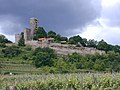
Wachenheim: Wachtenburg

Bad Dürkheim: sausage market

Bad Dürkheim: Limburg Monastery
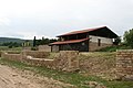
Ungstein: Villa rustica

Herxheim am Berg: Pfaffenhof
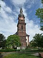
Grünstadt: Martinskirche
Bockenheim: Emichsburg

Monsheim: Castle

Dalsheim: Fleckenmauer

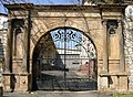
Alzey: Castle


In addition to the old wine-growing towns on or next to the B 271, there are also sights from Roman times , e.g. B. Remains of old country houses ( Villa rustica Weilberg ) or the Kriemhildenstuhl quarry . Above all on the heights of the Haardt, which rise west of the B 271, there are numerous historical buildings - castles , palaces and monasteries . In the Alzeyer hill country, such buildings are more likely to be in the town centers. From south to north, some of the most impressive are:
- Winzingen Castle with Haardter Castle near Neustadt an der Weinstrasse
- Wachtenburg near Wachenheim on the Wine Route
- Hardenburg and Limburg Abbey near Bad Dürkheim
- Castles Altleiningen , Neuleiningen and Battenberg in the Leiningerland
- Alzeyer Castle in the middle of the old town
South of Grünstadt, the B 271 is crossed by the Eckbach-Mühlenwanderweg , on which 23 historic and partially restored mills are located. At its eastern end point, about 6 km from the B 271, is the baroque two-church St. Laurentius in Dirmstein , which was built according to plans by the church builder Balthasar Neumann modified on site . The valleys and floodplains of watercourses such as Isenach , Eckbach , Eisbach , Pfrimm or Selz to the west of the B 271 still offer a lot of intact nature as well as small reservoirs such as the Isenachweiher , the Eckbachweiher , the Eiswoog and the Alzeyer reservoirs .
A visit to the Pechsteinkopf is worthwhile for those interested in geology . The 355 m high mountain west of Forst has an approximately 30 million year old igneous basalt deposit , which was mined until the 20th century and brought to the valley by cable car . In the Forster Pechstein vineyard on the mountain slope, thanks to the basalt soil, wines thrive that are among the top plants in Germany and often receive the Great Location quality level .
Individual evidence
- ↑ a b c d Map service of the landscape information system of the Rhineland-Palatinate nature conservation administration (LANIS map) ( notes )
- ↑ Anja Benndorf: West bypass Kirchheim: traffic rolls half a year earlier. In: The Rhine Palatinate . November 2, 2018, accessed December 10, 2018 .
- ↑ Announcement by the Rhineland-Palatinate State Mobility Agency in October 2014 ( memento from January 29, 2015 in the Internet Archive ).
- ↑ Calendar of events. German Wine Route, accessed January 1, 2019 .
- ^ Winzerfest Alzey , accessed on February 12, 2016.
- ↑ Celebrate festivals in Rheinhessen. Rheinhessen, archived from the original on September 3, 2011 ; Retrieved December 14, 2011 .