Ebersroda
|
Ebersroda
Gleina municipality
Coordinates: 51 ° 15 ′ 0 ″ N , 11 ° 46 ′ 0 ″ E
|
|
|---|---|
| Height : | 210 m above sea level NN |
| Area : | 4.27 km² |
| Residents : | 180 (Dec 31, 2007) |
| Population density : | 42 inhabitants / km² |
| Incorporation : | July 1, 2009 |
| Postal code : | 06632 |
| Area code : | 034632 |
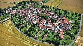
Ebersroda is a district of the municipality of Gleina in the Burgenland district in Saxony-Anhalt . The village belongs to the type of round square villages and has remained unchanged in this structure for centuries.
geography
The village is located between Müelte in the Geiseltal and Freyburg (Unstrut) on the Unstrut on the Querfurter Platte, about 220 m above sea level.
history
The places Ebersroda, Schnellroda , Albersroda , Baumersroda , Branderoda , Schleberoda , Petersroda (desert), Burghardsroda (desert) and Harterode (desert) are clearing villages of the Bamberg diocese .
As a horseshoe-shaped facility, Ebersroda has only one entrance or exit. It is one of the few Roundabout villages with preserved for centuries in its original form structure - for Anger include village pond, two wells houses, a brewery and a bakery. The grounds around the Anger are still closed today. The farmsteads with gates or portals were always renewed taking into account the high medieval floor plans. The back barn belt is completely preserved. The original village boundary is the path around the barns and the adjacent gardens and meadows.
The place was first mentioned in 1144 as Eberhaczrode . Owners were among others the v. Neustadt, v. Breitenbuch , v. Pigeon home .
Until 1815 the place belonged to the Wettin , later Electoral Saxon office of Freyburg . The decisions of the Congress of Vienna he came to Prussia and in 1816 the county Querfurt in the administrative district of Merseburg of the Province of Saxony assigned to which he belonged until 1944th
Until 1990, Ebersroda, like the other communities in this region, was dominated by agriculture. The last honorary mayor, Hans-Heinrich Opolka, was first elected on June 12, 1994. On July 1, 2009 Ebersroda was incorporated into Gleina.
church
The village church on the northeastern edge of the village is a hall church with a west tower. The square tower with coupled round-arched sound openings is originally a choir tower of a Romanesque building. Originally it belonged to the original parish of Müchi, later as a branch of Baumersroda to the Ephorie Freyburg.
Economy and Infrastructure
traffic
Ebersroda connects a local road with the neighboring town Baumersroda and a local road with the state road 163. Via the L 163 you get to the B 176, which runs south of the municipality and leads to Weißenfels and Sömmerda . Ebersroda is connected to Bundesstrasse 180 via Kreisstrasse 2642.
Individual evidence
- ^ Information board in Ebersroda, recorded on October 1, 2017
- ^ Karlheinz Blaschke , Uwe Ulrich Jäschke : Kursächsischer Ämteratlas. Leipzig 2009, ISBN 978-3-937386-14-0 ; P. 34 f.
- ↑ The district of Querfurt in the municipal directory 1900
- ↑ StBA: Area changes from January 2nd to December 31st, 2009


