Bundesstrasse 250
Bundesstraße 250 (abbreviation: B 250 ) is the name of two federal highways in Germany .
The fact that there are two Bundesstrasse 250 is a political curiosity that arose from the German-German division. It is one of the few German federal highways whose number is assigned several times (at the same time). When the Reichsstraßen were divided up in 1932, the road from Wanfried to Creuzburg was given the number 250. However, since it was only 17 kilometers long and in 1945 it was also cut by the inner-German border , the GDR administration decided in 1952 to use the long-distance road (GDR counterpart to the West German federal highway), which was completely in the border area and therefore not without it Permit could be used to dissolve. In the same year Nebra became a district town in what is now Saxony-Anhalt (then Halle district ). In the GDR it was desired that every district town should be accessible via at least one trunk road. Since Nebra did not yet have one, it was decided to raise the road from Querfurt in the north to Eckartsberga in the south to a trunk road and expand it. This is how the only F 250 in the GDR was created. After reunification in 1990, as part of infrastructure improvement measures in the former border area, the old road number 250 was revived as the B 250 by Treffurt. On the other hand, the road from Querfurt to Eckartsberga also remained with the designation B 250, and so there are two federal roads with the number 250 in Germany today.
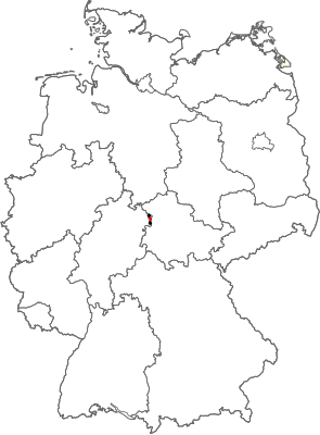
B 250 (Wanfried - Treffurt - Creuzburg)
| Bundesstrasse 250 in Germany | ||||||||||||||||

|
||||||||||||||||
| map | ||||||||||||||||
| Basic data | ||||||||||||||||
| Operator: |
|
|||||||||||||||
| Overall length: | 17 km | |||||||||||||||
|
State : |
||||||||||||||||
|
Course of the road
|
||||||||||||||||
The federal highway 250 is a 17 kilometer long federal highway in East Hesse and West Thuringia.
It begins on the B 249 ( Eschwege - Mühlhausen ) in Wanfried ( Werra-Meißner district , Hesse ). It leaves the city in a southerly direction and runs through the Werra valley to Treffurt, seven kilometers away ( Wartburg district , Thuringia ). Between 1952 and 1990 the federal highway on the German-German border was interrupted; there was no border crossing here either . South of the old town of Treffurt, the B 250 leads over a Werra bridge, which was completed in 1998, and again to the south via the Schnellmannshausen and Volteroda districts. It then ends at the former Roter Kopf rest house and joins the B 7 ( Eisenach - Kassel ) between Creuzburg and Ifta . However, the importance of this short federal road for traffic is rather low.
B 250 (Querfurt - Nebra - Bad Bibra - Eckartsberga)
| Bundesstrasse 250 in Germany | |||||||||||||||||||||||||||||||||||||||||||

|
|||||||||||||||||||||||||||||||||||||||||||
| map | |||||||||||||||||||||||||||||||||||||||||||
| Basic data | |||||||||||||||||||||||||||||||||||||||||||
| Operator: |
|
||||||||||||||||||||||||||||||||||||||||||
| Overall length: | 38 km | ||||||||||||||||||||||||||||||||||||||||||
|
State : |
|||||||||||||||||||||||||||||||||||||||||||
|
Course of the road
|
|||||||||||||||||||||||||||||||||||||||||||
The federal highway 250 is a 38-kilometer national highway in southwest Saxony-Anhalt .
It begins on the B 180 ( Eisleben - Naumburg (Saale) ) south of Querfurt . A bypass has been completed here since 2006. The B 250 leaves the city in a southerly direction. After about ten kilometers it reaches the valley of the Unstrut , in which it runs a further three kilometers upstream. There it leads across a bridge to Nebra , a small town, the 1952-1994 county seat was and by the materials found there Nebra sky disk was known. It leaves the city in a southerly direction and rises from the valley of the Unstrut to the Saale-Unstrut-Triasland (a geological hill formation). There it meets the B 176 ( Sömmerda - Weißenfels ) after 13 kilometers in Bad Bibra . After leaving the city, it leads another twelve kilometers over the Saale-Unstrut-Triasland with its vineyards , before it ends in Eckartsberga on the B 87 ( Apolda - Naumburg (Saale)).

