Bundesstrasse 274
| Bundesstrasse 274 in Germany | ||||||||||||||||||||||||||||||||||||||||||||||||||||||||||||||||

|
||||||||||||||||||||||||||||||||||||||||||||||||||||||||||||||||
| map | ||||||||||||||||||||||||||||||||||||||||||||||||||||||||||||||||
| Basic data | ||||||||||||||||||||||||||||||||||||||||||||||||||||||||||||||||
| Operator: |
|
|||||||||||||||||||||||||||||||||||||||||||||||||||||||||||||||
| Start of the street: |
Sankt Goarshausen ( 50 ° 10 ′ N , 7 ° 43 ′ E ) |
|||||||||||||||||||||||||||||||||||||||||||||||||||||||||||||||
| End of street: |
Customs house ( 50 ° 17 ′ N , 8 ° 4 ′ E ) |
|||||||||||||||||||||||||||||||||||||||||||||||||||||||||||||||
| Overall length: | 34.2 km | |||||||||||||||||||||||||||||||||||||||||||||||||||||||||||||||
|
State : |
||||||||||||||||||||||||||||||||||||||||||||||||||||||||||||||||
|
Course of the road
|
||||||||||||||||||||||||||||||||||||||||||||||||||||||||||||||||
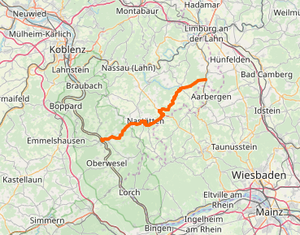
The federal road 274 (abbreviation: B 274 ) leads from the Middle Rhine Valley over the plateaus of the Hintertaunus into the Aartal , starting at the B 42 in Sankt Goarshausen , with a bypass road past Nastätten , through Holzhausen an der Haide , crossing the Bäderstraße , and on over Katzenelnbogen to the B 54 in Zollhaus ( Verbandsgemeinde Aar-Einrich ).
It runs entirely in Rhineland-Palatinate. Between Naststätten and Holzhausen, the state border with Hesse approaches the road to a few meters.
history
Originally the federal road 274 ran through Nastätten and Buch directly to Holzhausen . Later it was moved to a route that bypasses both places to the south, which joins the B 260 at a roundabout , which the B 274 now follows for a short distance to Holzhausen, where it branches off again and continues on its way to Katzenelnbogen.
The old route over book became a county road graded 107th In the town of Buch it still bears the street name Bundesstraße .
Overview
- Length: 34.2 km
- Starting point: Sankt Goarshausen
- End point: customs house
course
-
Sankt Goarshausen

- Bogel
- Nasta
-
Holzhausen an der Haide

- Saves
- Oberfischbach
- Mittelfischbach
- Katzenelnbogen
-
Customs House

Web links
- Federal Highway Research Institute: Federal road directory with long-distance and local destinations. (PDF, 2.68 MB) Federal Ministry of Transport, Building and Urban Development, August 1, 2009, p. 288 , accessed on July 21, 2017 .
