
Katzenelnbogen
| coat of arms | Germany map | |
|---|---|---|

|
Coordinates: 50 ° 16 ' N , 7 ° 59' E |
|
| Basic data | ||
| State : | Rhineland-Palatinate | |
| County : | Rhein-Lahn district | |
| Association municipality : | Aar facility | |
| Height : | 280 m above sea level NHN | |
| Area : | 9.2 km 2 | |
| Residents: | 2144 (Dec. 31, 2019) | |
| Population density : | 233 inhabitants per km 2 | |
| Postal code : | 56368 | |
| Area code : | 06486 | |
| License plate : | EMS, DIZ, GOH | |
| Community key : | 07 1 41 068 | |
| LOCODE : | DE 83K | |
| Association administration address: | Burgstrasse 1 56368 Katzenelnbogen |
|
| Website : | ||
| City Mayor: | Petra Popp (FWG) | |
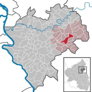
| Location of the city Katzenelnbogen in the Rhein-Lahn-Kreis | ||
  |
||

Katzenelnbogen is a town in the Rhein-Lahn district in Rhineland-Palatinate . It is the administrative seat of the municipality of Aar-Einrich , to which it also belongs. Katzenelnbogen is designated as a basic center in accordance with state planning .
Location and geography
The town of Katzenelnbogen is located in the northeast of Rhineland-Palatinate in Einrich , a 250 to 450 meter high northwestern part of the Taunus . The southeastern border of the Nassau Nature Park runs through Katzenelnbogen .
Katzenelnbogen also includes the residential areas Gut Margaretenhof, the Hibernia trade union, Höfe am Michert, Itzhäusermühle, Moorenmühle and Talhof.
The old town lies in the valley of the Dörsbach at 280 m above sea level. NHN and extends up to 300 m above sea level. NHN up the Katzenelnbogen castle hill. More recent development from the second half of the 20th century extends to the immediately surrounding heights, followed by agricultural areas and forests. The closer environment rises in the south up to 400 m above sea level. NHN , while the landscape in the north is 300 to 350 m above sea level. NHN forms a plateau with valleys.
climate
The annual precipitation is 697 mm. The precipitation is in the middle third of the values recorded in Germany. Lower values are registered at 39% of the measuring stations of the German Weather Service . The driest month is February, with the most rainfall in June. In June there is 1.6 times more rainfall than in February. Precipitation varies only minimally and is extremely evenly distributed over the year. Lower seasonal fluctuations are recorded at only 3% of the measuring stations .
Neighboring communities
In the north, the city borders directly on the town of Klingelbach . Another neighboring municipality is Allendorf , which is about a kilometer away in the east. The nearest medium-sized center is the northeastern city of Diez .
history

The Burg Katzenelnbogen was around 1095 on Bleidenstädter built Vogteigut. The first documentary mention of the place dates back to the same year. A dynasty of counts who were related to the Hohenstaufen dynasty at the time named themselves after the castle . It acquired significant land during the interregnum . Around the year 1260, the brothers Diether and Eberhard divided the county between them, which only reunited around 1402 and then ruled an area from the Odenwald to the lower Lahn, albeit in two parts, the so-called Niedergrafschaft around Katzenelnbogen and St. Goar and the so-called Upper County in the Rhine-Main triangle around Darmstadt. The former included places like Braubach and St. Goar , the latter Rüsselsheim , Groß-Gerau , Darmstadt and Zwingenberg .
The house obtained an important source of income through customs duties on ships that sailed the Rhine, as well as in Darmstadt an der Bergstrasse , which he founded , a trade route that led from Heidelberg to Frankfurt am Main . This made them one of the richest counties in the Holy Roman Empire of the German Nation .
The Counts of Katzenelnbogen played an important role and are said to have had one of the largest silver hoards in Germany, which they used politically to grant loans to other genders and thus secure their influence. The house provided u. a. Bishops in Münster and Osnabrück , with Diether von Katzenelnbogen towards the end of the 12th century a chancellor of the empire and a king mother of Adolf von Nassau . Diether VI. of Katzenelnbogen received for his services on 19 July 1312 by Emperor Henry VII. , the town charter for Katzenelnbogen awarded. After Darmstadt was made a city in 1330, the Counts of Katzenelnbogen moved their permanent seat there. The further development of the city of Katzenelnbogen then stagnated.
In 1479 the counts died out in the male line. After major inheritance disputes with Nassau , his property finally fell to the Landgraviate of Hesse in 1557 . Here, in turn, the southern parts later fell to the Landgraviate of Hessen-Darmstadt , the northern parts to Hessen-Kassel . From 1798 to 1814 the parts of the County of Katzenelnbogen (Rheinfels, St. Goar and Pfalzfeld) lying west of the Rhine belonged to the First French Republic . The part of the Electorate of Hesse fell to the Duchy of Nassau in 1815 . After the German War , Katzenelnbogen came to the Prussian province of Hessen-Nassau in 1866 . As part of the Prussian community reform, Katzenelnbogen lost its town charter.
The onset of industrialization in Germany after 1850 brought a gradual improvement in the living situation for the residents of Katzenelnbogen, in particular due to the strengthened mining of iron ore, see Zollhaus mine . Until the Second World War , however, the place was dominated by agriculture. This only changed in the 1950s with the creation of new jobs, especially in the neighboring metropolitan centers as part of the economic miracle .
In 1946 the state of Rhineland-Palatinate was formed. For the 650th anniversary of the city charter in 1962, Katzenelnbogen was again granted city charter. In 1972, in the course of the Rhineland-Palatinate "functional and territorial reform", the community of Katzenelnbogen was formed , the administrative seat of which was the city of Katzenelnbogen and which then became part of the community of Aar-Einrich.
etymology

The origin of the name "Katzenelnbogen" has not been finally clarified. It could go back to the Latin name cattimelibocus . Catti or Chatti goes to the Germanic people of the chat back while Melibocus hill or mountain means. In the immediate vicinity of Katzenelnbogen there are several burial mounds that testify to an early settlement. In 1783, however, the historian Helfrich Bernhard Wenck classified this interpretation as untenable. In 1952 Karl E. Demandt underpinned the interpretation of Adolf Bach (1927) and Wilhelm Kapsers (1937) that the name should be translated as "small / angled (brook) curvature". The term "Katzenelnbogen" only appears under the counts.
Population development
The development of the population of Katzenelnbogen, the values from 1871 to 1987 are based on censuses:
|
|
politics
City council
The city council in Katzenelnbogen consists of 16 council members, who were elected in a personalized proportional representation in the local elections on May 26, 2019 , and the honorary city mayor as chairman.
The distribution of seats in the city council:
| choice | SPD | CDU | FWG | total |
|---|---|---|---|---|
| 2019 | 5 | 5 | 6th | 16 seats |
| 2014 | 5 | 7th | 4th | 16 seats |
| 2009 | 6th | 6th | 4th | 16 seats |
| 2004 | 6th | 7th | 3 | 16 seats |
- Free voter group "Einrich" e. V.
mayor
Mayor of Katzenelnbogen is Petra Popp (FWG). In the direct election on May 26, 2019, she was elected with 84.20% of the vote and is the successor to Horst Klöppel (CDU), who did not run again.
Town twinning
Katzenelnbogen has been twinning with the French city of Serres (Hautes-Alpes) since 1990 .
Culture and sights
Buildings
The Burg Katzenelnbogen dates from the 11th century. The wall, a gate tower and the main house built in the 16th century have been preserved.
The Catholic Church of St. Peter was built in the neo-Gothic style in 1874/75 . The high altar made in 1906 is striking.
See also:
Regular events
On the penultimate weekend in August, the Bartholomäusmarkt organized by the Einrich Heimatverein takes place. It goes back to a market introduced after the city was founded in 1312, which over time changed from a weekly market to a fair.
The Katzenelnbogen Ritterspiele have been taking place on the first weekend in June since 2007 , inspired by the historical ring prick that can be seen on an old view of Katzenelnbogen.
Economy and Infrastructure
As a market town, the town of Katzenelnbogen is the central shopping option for the surrounding towns in the Einrich . Other sources of income for the city are tourism, two retirement homes and a specialist clinic for psychiatry and psychotherapy led by Wolfgang Eirund, among others. With its supraregional catchment area and its approx. 3,000 patients (approx. 750 inpatients and 2,300 outpatients), this specialist clinic is the city's largest employer each year.
traffic
Katzenelnbogen is away from major traffic routes. The place is connected via the B 274 to St. Goarshausen and to the B 54 at Zollhaus im Aartal . The state road 318 leads via Diez to the B 54 to Limburg . Bus lines of the Rheingau-Taunus-Verkehrsgesellschaft or the Nassauische Verkehrs-GmbH connect Katzenelnbogen several times a day with Wiesbaden , St. Goarshausen and Limburg. Until the 1950s, Katzenelnbogen was connected to the rail network via the Nassauische Kleinbahn .
sons and daughters of the town
- Meir Katzenellenbogen (1482–1565), Talmudic scholar, Rabbi of Padua and Venice
- Stefan Römer (* 1960), German artist, art historian and professor
- Armin Scholl (* 1966), economist, professor for business decision analysis
See also
literature
- Literature about Katzenelnbogen in the Hessian Bibliography
- Hans Jeske: The name Katzenelnbogen . In: Contributions to Name Research Ser. NS. tape 24 , 1989, pp. 332–347 ( excerpt from Google Books).
Web links
- Illustration by Daniel Meisner from 1624: Catzenelnbogen; Dux Macedûm Corpore Parvus Erat ( digitized version )
- City of Katzenelnbogen on the website of the municipality of Aar-Einrich
Individual evidence
- ↑ a b State Statistical Office of Rhineland-Palatinate - population status 2019, districts, municipalities, association communities ( help on this ).
- ↑ a b State Statistical Office Rhineland-Palatinate - regional data
- ↑ State Statistical Office Rhineland-Palatinate (ed.): Official directory of the municipalities and parts of the municipality. Status: January 2018 [ Version 2020 is available. ] . S. 42 f . (PDF; 2.2 MB).
- ↑ State Surveying Office Rhineland-Palatinate: Topographic map 1: 25,000 Nassau Nature Park. Sheet 5 (east). Verbandsgemeinden Diez and Katzenelnbogen. Koblenz 1993. ed.
- ^ Meyers Konversationslexikon 1888, Vol. 9, page 623
- ^ Meyers Konversationslexikon 1888, Vol. 11, page 449.
- ^ Helfrich Bernhard Wenck: Hessian national history. With a document book and geographical charts. tape 1 . Darmstadt and Giessen 1783.
- ↑ Karl E. Demandt: Regesten der Graf von Katzenelnbogen . tape 1 . Wiesbaden 1953, p. 799 .
- ^ The Regional Returning Officer Rhineland-Palatinate: Local elections 2019, city and municipal council elections
- ^ The Regional Returning Officer Rhineland-Palatinate: direct elections 2019. see Aar-Einrich, Verbandsgemeinde, 17th line of results. Retrieved November 21, 2019 .

Allendorf | Altendiez | Arzbach | Attenhausen | Auel | Aull | Bad Ems | Balduinstein | Becheln | Mountain | Berghausen | Berndroth | Bettendorf | Biebrich | Birlenbach | Bogel | Bornich | Braubach | Bremberg | Book | Burgschwalbach | Charlottenberg | Cramberg | Dachsenhausen | Dahlheim | Dausenau | Dessighofen | Dienethal | Diethardt | Diez | Dörnberg | Dornholzhausen | Dörscheid | Dörsdorf | Ebertshausen | Honor | Eisighofen | Endlichhofen | Eppenrod | Ergeshausen | Eschbach | Fachbach | Filsen | Flat | Fruit | Geilnau | Geisig | Gemmerich | Gückingen | Gutenacker | Hahnstätten | Hainau | Hambach | Heistenbach | Herald | Himmighofen | Hirschberg | Holzappel | Holzhausen an der Haide | Holzheim | Hömberg | Horhausen | Hunzel | Isselbach | Kaltenholzhausen | Kamp-Bornhofen | Kasdorf | Katzenelnbogen | Kaub | Kehlbach | Kemmenau | Kestert | Klingelbach | Kördorf | Lahnstein | Langenscheid | Laurenburg | Lautert | Liiffer | Lipporn | Lohrheim | Lollschied | Lykershausen | Marienfels | Miehlen | Mielle | Misselberg | Mittelfischbach | Mudershausen | Nassau | Nasta | Netzbach | Niederbachheim | Niederneisen | Niedertiefenbach | Niederwallmenach | Never | Nochern | Oberbachheim | Oberfischbach | Oberneisen | Obernhof | Obertiefenbach | Oberwallmenach | Oberwies | Oelsberg | Osterspai | Patersberg | Pohl | Prath | Reckenroth | Reichenberg | Reitzenhain | Rescue Grove | Rescues | Roth | Ruppertshofen | Sankt Goarshausen | Sauerthal | Scheidt | Schiesheim | Schönborn | Schweighausen | Seelbach | Singhofen | Steinsberg | Strüth | Sulzbach | Wasenbach | Weidenbach | Weinähr | Weisel | World destruction | Weyer | Winches | Winter advertising | Room difference